Skip to search
Skip to main content
Skip to first result
Search
You Searched For
Extent of Digitization
Completely digitized
Genre
Atlases
Genre
Engravings
New Search
Search Results
Creator:
Published / Created:
a. 1760
Call Number:
1973 Folio 30
Collection Title:
[Atlas factice of 32 maps and 1 distance table, produced by the Homann Erben firm]
Image Count:
2
Alternative Title:
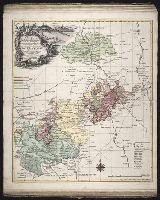
Comitatus Schoenburgensis
Publisher:
Edentibus Homannianis Heredibus
Subject (Geographic):
Zwickau (Germany : Landkreis) --Maps --Early works to 1800
Subject (Topic):
Atlases, German --Early works to 1800
Collection Created:
[Nuremberg : s.n.,
Found in:
Beinecke Rare Book and Manuscript Library > Comitatvs Schoenburgensis [cartographic material] : in quo celsissimorum comitum de Schoenburg regiones ad circulum Saxoniae superiorem Imperii Romano-Germanici pertinentes et in Marchionatu Misniae sitae, subfeuda porro Bohemico-Imperialia, nempe Dynasti
Creator:
Published / Created:
1750
Call Number:
1973 Folio 30
Collection Title:
[Atlas factice of 32 maps and 1 distance table, produced by the Homann Erben firm]
Image Count:
2
Publisher:
[Matthaeus Seutter?]
Subject (Geographic):
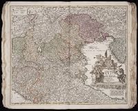
Saxony-Anhalt (Germany) --Maps --Early works to 1800
Subject (Topic):
Atlases, German --Early works to 1800
Collection Created:
[Nuremberg : s.n., 1701-1760]
Found in:
Beinecke Rare Book and Manuscript Library > Delineatio geographica comitatus Mansfeldensis ad jurisdictionem tum Saxonicam tum Brandenburgicam spectans, cum praefectura Sangerhusana, Querfurtensi, Sittenbacensi, Allstaedensi, et loci finitimis / [cartographic material] / cura Matth. Seutteri, Geogr
Creator:
Published / Created:
ca. 1757
Call Number:
1973 Folio 30
Collection Title:
[Atlas factice of 32 maps and 1 distance table, produced by the Homann Erben firm]
Image Count:
2
Publisher:
[Tobias Conrad Lotter?]
Subject (Geographic):
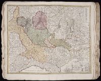
Greiz (Germany : Landkreis) --Maps --Early works to 1800
Subject (Topic):
Atlases, German --Early works to 1800
Collection Created:
[Nuremberg : s.n.,
Found in:
Beinecke Rare Book and Manuscript Library > Delineatio geographica specialis territorii celsissimorum S.R.I. comitum Ruthenorum de Plauia [cartographic material] : utriusque linea senioris et iunioris partem Vogtlandiae / opera et studio Ioh. Gottlieb Schulzii, S.C.M. Ingen. Lieut. ; accurate edita
Creator:
Published / Created:
1720?
Call Number:
1975 Folio 31
Collection Title:
[Atlas factice of 42 maps, produced by the Homann Erben firm]
Image Count:
1
Publisher:
Johann Baptist Homann
Subject (Geographic):
Italy, Northern --Maps --Early works to 1800 and Veneto (Italy) --Maps --Early works to 1800
Subject (Topic):
Atlases, German --Early works to 1800
Collection Created:
[Nuremberg,
Found in:
Beinecke Rare Book and Manuscript Library > Dominii Veneti cum vicinis Parmae, Mutinae, Mantuae, et Mirandolae statibus nova descriptio / [cartographic material] / edita a Ioh. Baptista Homanno, sacrae caes. majestatis geographo
Creator:
Published / Created:
1758
Call Number:
1973 Folio 30
Collection Title:
[Atlas factice of 32 maps and 1 distance table, produced by the Homann Erben firm]
Image Count:
2
Publisher:
[Tobias Conrad Lotter]
Subject (Geographic):
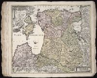
Halle (Germany : Regierungsbezirk) --Maps --Early works to 1800 and Magdeburg (Germany : Regierungsbezirk) --Maps --Early works to 1800
Subject (Topic):
Atlases, German --Early works to 1800
Collection Created:
[Nuremberg : s.n., 1701-1760]
Found in:
Beinecke Rare Book and Manuscript Library > Ducatus Magdeburgensis et Halensis cum finitimis delineation geographica / [cartographic material] / curante Matthaeo Seuttero, Geographo. Caeser
Creator:
Published / Created:
1730?
Call Number:
1975 Folio 31
Collection Title:
[Atlas factice of 42 maps, produced by the Homann Erben firm]
Image Count:
1
Publisher:
Homann
Subject (Geographic):
Milan (Italy : Province) --Maps --Early works to 1800
Subject (Topic):
Atlases, German --Early works to 1800
Collection Created:
[Nuremberg,
Found in:
Beinecke Rare Book and Manuscript Library > Ducatus Mediolani una cum confinyes accurata tabula / [cartographic material] / exhibitus auctus et eme[n]datus per Ioh. Bapt. Homannum
Creator:
Published / Created:
[ca. 1696]
Call Number:
1973 Folio 10
Image Count:
1
Resource Type:
Maps, Atlases & Globes
Description:
Bar scales in Milliaria Germanica Communia and Milliaria Gallica Communia., Ferro meridian., No. 37 of 69 maps bound together in composite atlas., Relief shown pictorially., and Scale [ca. 1:775 000].
Publisher:
[Frederik de Wit]
Subject (Geographic):
Prussia, east (Poland and Russia) --Maps --Early works to 1800
Found in:
Beinecke Rare Book and Manuscript Library > Ducatus Prussiae tam Polono Regiae quam Brandenburgo Ducalis : correcta descriptio et divisio Regiae scilicet in tres Palatinatus, et Ducalis in totidem circulos, cum utrius[que] subdivisione in tractus minores
Creator:
Published / Created:
1730
Call Number:
1975 Folio 31
Collection Title:
[Atlas factice of 42 maps, produced by the Homann Erben firm]
Image Count:
1
Alternative Title:
Ducatuum Livoniae et Curlandiae cum vicinis insulis
Publisher:
Johann Baptist Homann
Subject (Geographic):
Estonia --Maps --Early works to 1800 and Latvia --Maps --Early works to 1800
Subject (Topic):
Atlases, German --Early works to 1800
Collection Created:
[Nuremberg,
Found in:
Beinecke Rare Book and Manuscript Library > Ducatvvm Livoniae et Cvrlandiae cum vicinis insulis [cartographic material] : nova exhibitio geographica / editore Ioh. Baptista Homanno
Creator:
Published / Created:
1746
Call Number:
1975 Folio 31
Collection Title:
[Atlas factice of 42 maps, produced by the Homann Erben firm]
Image Count:
1
Alternative Title:
Ducatus Silesiae tabula altera superiorem Silesiam exhibens and Haute Silesie, qui comprend les Principautes de Neise, de Munsterberg, de Laegerndorf, de Troppau, d’Oppeln, de Ratibor, de Teschen dessinee par les Heritiers de Homann, l’an 1746
Publisher:
Homann Erben
Subject (Geographic):
Silesia, Upper (Poland and Czech Republic) --Maps --Early works to 1800
Subject (Topic):
Atlases, German --Early works to 1800
Collection Created:
[Nuremberg,
Found in:
Beinecke Rare Book and Manuscript Library > Dvcatvs Silesiae tabvla altera svperiorem Silesiam exhibens / [cartographic material] / ex mappa Hasiana majore desumta & excusa per Homan[n]ianos Heredes
Creator:
Published / Created:
1745
Call Number:
1975 Folio 31
Collection Title:
[Atlas factice of 42 maps, produced by the Homann Erben firm]
Image Count:
1
Alternative Title:
Basse Silesie qui comprend les Principautes de Schweidnitz, de Iauer, de Glogau, de Breslau, de Liegnitz, de Brieg, de Wolau, de Oels & de Sagan and Ducatus Silesiae tabula geographica prima inferiorem eius partem
Publisher:
Homann Erben
Subject (Geographic):
Silesia, Lower (Poland and Germany) --Maps --Early works to 1800
Subject (Topic):
Atlases, German --Early works to 1800
Collection Created:
[Nuremberg,
Found in:
Beinecke Rare Book and Manuscript Library > Dvcatvs Silesiae tabvla geographica prima inferiorem eivs partem, seu novem principatvs, quorum insignia hic adjecta sunt, secundum statum recentissimium complectens / [cartographic material] / ad mentem Hasiani avtographi majoris legitime delineata et ed
Branch:v1.61.6 ,Deployed:2024-06-12T09:55:37-04:00