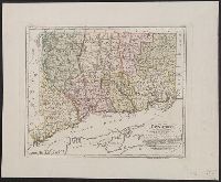
"Zu Ebelings Erdbeschreib, Also shows county boundaries., Bar scales given in "Geographische Meilen 15 auf einen Grad" and "Englische meilen 69 4/25 auf einen Grad.", In upper right margin: No. VI., Place names in German and English., and Relief shown by hachures.
Publisher:
Bey Carl Ernst Bohn,
Subject (Geographic):
Connecticut--Administrative and political divisions--Maps--Early works to 1800 and Connecticut--Maps--Early works to 1800
Subject (Name):
Bohn, Carl Ernst, Ebeling, Christophe Daniel, 1741-1817. Erdbeschreibung und Geschichte von Amerika, and Schmidt, Paulus, engraver
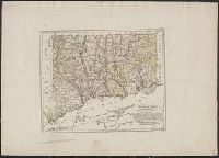
"Zu Ebelings Erdbeschreibung von Amerika.", Also shows county boundaries., Bar scales given in "Geographische Meilen 15 auf einen Grad" and "Englische meilen 69 4/25 auf einen Grad.", In upper right margin: No. VI., Place names in German and English., and Prime me
Publisher:
Bey Carl Ernst Bohn,
Subject (Geographic):
Connecticut--Administrative and political divisions--Maps--Early works to 1800 and Connecticut--Maps--Early works to 1800
Subject (Name):
Bohn, Carl Ernst, Ebeling, Christophe Daniel, 1741-1817. Erdbeschreibung und Geschichte von Amerika, and Schmidt, Paulus, engraver
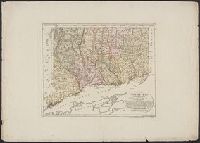
"Zu Ebelings Erdbeschreibung von Amerika.", Also shows county boundaries., Bar scales given in "Geographische Meilen 15 auf einen Grad" and "Englische meilen 69 4/25 auf einen Grad.", In upper right margin: No. VI., Place names in German and English., and Prime me
Publisher:
Bey Carl Ernst Bohn,
Subject (Geographic):
Connecticut--Administrative and political divisions--Maps--Early works to 1800 and Connecticut--Maps--Early works to 1800
Subject (Name):
Bohn, Carl Ernst, Ebeling, Christophe Daniel, 1741-1817. Erdbeschreibung und Geschichte von Amerika, and Schmidt, Paulus, engraver
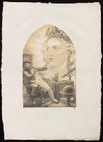
An advertisement, laid in, presenting the first Heft and soliciting subscriptions for future Hefte, gives a date in 1826 as closing time for subscriptions. Goethe mentions having seen the second Heft in a letter from the year 1828., Goethe commented on the first and second Hefte in Kunst und Altertum, v. 6., Illustrations to Faust I only., and Wanting plate I.
Publisher:
Hamburger Steindruck, in Commission bey J.M. Commeter,
Subject (Name):
Goethe, Johann Wolfgang von,--1749-1832.--Faust--Illustrations.
"Folgen die Melodien der Lieder, welche in disem Ballett wurden gesungen": leaves 26-27r., Bookplate of Arthur F. Hill. Binder's stamp: Riviere & Son., Description, including song lyrics and music, of a ballet performed as part of the celebration surrounding the marriage of Christian Louis of Brunswick-Lüneburg with Dorothea of Schleswig-Holstein., Illustrations: 23 etchings by Konrad Buno and August John (the latter's unsigned) comprising 20 dance scenes and 3 stage settings., Published also (with more music) at Lüneburg, presumably in 1653., and Words of the songs by Johann Rist; choreography presumably by Du Haj and Jan den Hoecke who are mentioned as "Dantz-Meister" in the list of dances (leaf 27v); music by unknown composer ascribed in Eitner's Quellen-Lexikon to Stephen Körner.
Publisher:
Gedruckt bey Jacob Rebenlein,
Subject (Name):
Buno, Konrad, d. 1671., Christian Louis,--Duke of Brunswick-Lüneburg,--1625-1665--Marriage., Dorothea,--Duchess of Schleswig-Holstein,--1636-1689--Marriage., Hill, Arthur F.--(Arthur Frederick),--1860-1939--Bookplate., John, August, b. 1602., Rist, Johann, 1607-1667., and Riviere & Son, binder.
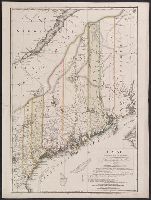
"Zu Ebelings Erdbeschreibung von America.", Also shows county boundaries., Bar scales given in "Geographische Meilen 15 auf einen Grad" and "Englische meilen 69 4/25 auf einen Grad.", Includes index to land grants., Place names in German and Englis, and Watermark.
Publisher:
Bey Carl Ernst Bohn,
Subject (Geographic):
Maine--Administrative and political divisions--Maps--Early works to 1800 and Maine--Maps--Early works to 1800
Subject (Name):
Bohn, Carl Ernst, Ebeling, Christoph Daniel,--1741-1817--Presentation inscription to N. Webster, Ebeling, Christophe Daniel, 1741-1817. Erdbeschreibung und Geschichte von Amerika, and Sander, Wilhelm, 1766-1836, engraver
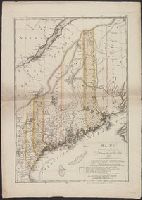
"Zu Ebelings Erdbeschreibung von America.", Also shows county boundaries., In upper right margin: No. IV., Includes index to land grants., Place names in German and English., Prime meridians: Greenwich a, Relief shown by hachures., and Sheet measures 75.5 x 53.8 cm.
Publisher:
Bey Carl Ernst Bohn,
Subject (Geographic):
Maine--Administrative and political divisions--Maps--Early works to 1800 and Maine--Maps--Early works to 1800
Subject (Name):
Bohn, Carl Ernst, Ebeling, Christophe Daniel, 1741-1817. Erdbeschreibung und Geschichte von Amerika, and Sander, Wilhelm, 1766-1836, engraver