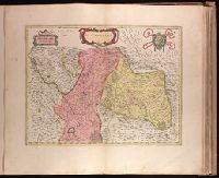
Backed with paper. Ms. no. "73" in upper right corner. Sheet measures 53.6 x 63.0 cm. No. 68 of 87 maps bound together., Bar scale given in "miglia sette d'Italia.", and Relief shown pictorially.
Publisher:
Joan Blaeu,
Subject (Geographic):
Milan (Italy : Province)--Maps--Early works to 1800.
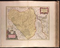
Appeared in Valk and Schenk's Atlantis sylloge compendiosa, ca. 1702., Backed with paper. Ms. no. "29" in upper left-hand corner. Sheet measures 53.5 x 62.5 cm. No. 29 of 87 maps bound together., Includes five bar scales., Prime meridian: Ferro., Relief shown pictorially., and Watermark.
Publisher:
Gerard Valk,
Subject (Geographic):
Switzerland--Maps--Early works to 1800.
Subject (Name):
Schenk, Peter, 1660-1718 or 1719. Atlantis sylloge compendiosa. and Valck, G. (Gerard), 1651 or 1652-1726. Atlantis sylloge compendiosa.
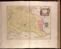
Backed with paper. Ms. no. "70" in upper right corner. Sheet measures 53.6 x 63.3 cm. No. 65 of 87 maps bound together., Bar scale given in "miglia cinque.", and Relief shown pictorially.
Publisher:
Joan Blaeu,
Subject (Geographic):
Belluno (Italy : Province)--Maps--Early works to 1800.
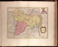
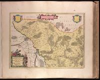
Backed with paper. Ms. no. "69" in upper right corner. Sheet measures 53.5 x 62.5 cm. No. 64 of 87 maps bound together., Bar scale given in "miglia cinque.", and Relief shown pictorially.
Publisher:
Joan Blaeu,
Subject (Geographic):
Italy, Northern--Maps--Early works to 1800. and Veneto (Italy)--Maps--Early works to 1800.
Backed with paper. Ms. no. "27" in upper right-hand corner. Sheet measures 52.7 x 53.7 cm. No. 27 of 87 maps bound together., Bar scales given in "milliaria Germanica" and "mill. Gallica"., Prime meridian: Ferro., and Relief shown pictorially.
Publisher:
Peter Schenk,
Subject (Geographic):
Austria--Maps--Early works to 1800. and Bavaria (Germany)--Maps--Early works to 1800.
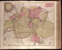
"Cum Privilegio Ordin: General: Belgii Foederati.", Backed with paper. Ms. no. "95" in upper right-hand corner. Sheet measures 53.6 x 62.1 cm. No. 85 of 87 maps bound together., Bar scales given in "sesqui milliare Germanicum" and "milliaria Gallica.", Date given by Koeman, v. 5, p. 201, col. 2., and Relief shown pictorially.
Appears in Justus Danckerts's first two Atlas editions; see Koeman, C. Atlantes Neerlandici, vol. III, Dan 1, Dan 2., Backed with paper. Ms. no. "59" in upper right-hand corner. Sheet measures 53.8 x 62.8 cm. No. 54 of 87 maps bound together., Bar scales given in "milliaria Germanica communia" and "milliaria Gallica communia"., Prime meridian: Ferro., and Relief shown pictorially.
Publisher:
Theodore Danckerts,
Subject (Geographic):
Alsace (France)--Maps--Early works to 1800., Baden-Württemberg (Germany)--Maps--Early works to 1800., Lorraine (France)--Maps--Early works to 1800., and Saarland (Germany)--Maps--Early works to 1800.
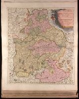
Backed with paper. Ms. no. in upper right corner: 21. Sheet measures 53.7 x 62.5 cm. No. 21 of 87 maps bound together., Bar scale given in "milliaria Germanica"., Dedication cartouche with blank text panel and blank shield., and Prime meridian: Ferro.
Publisher:
Joan Blaeu,
Subject (Geographic):
Saxony-Anhalt (Germany)--Maps--Early works to 1800.
Backed with paper. Ms. no. in upper right corner: 18. Sheet measures 53.6 x 62.9 cm. No. 18 of 87 maps bound together., Bar scale given in "milliaria Germanica"., Prime meridian: Ferro., and With two blank shields.
Publisher:
Joan Blaeu,
Subject (Geographic):
Brandenburg (Germany : Landkreis)--Maps--Early works to 1800.