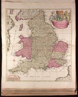
"Cum privilegio.", Appeared in Peter Schenk's Atlas contractus, ca. 1700., Backed with paper. Ms. no. "48" in lower-right corner. Sheet measures 62.8 x 53.7 cm. No. 45 of 87 maps bound together., Bar scales given in "milliaria Anglica," "milliaria Germanica," and "milliaria Gallica"., Prime meridian: Ferro., Relief shown pictorially., and Watermark.
Publisher:
Peter Schenk,
Subject (Geographic):
England--Maps--Early works to 1800.
Subject (Name):
Schenk, Peter, 1660-1718 or 1719. Atlas contractus.
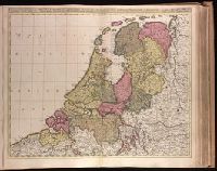
Appears in Valk and Schenk's Atlantis sylloge compendiosa, ca. 1702., Backed with paper. Ms. no. "40" in upper-right corner. Sheet measures 53.6 x 63.0 cm. No. 39 of 87 maps bound together., Bar scales given in "horae itinerissive milliaria Gallica" and "milliaria Germanica"., Prime meridian: Ferro., and Watermark.
Publisher:
Gerard Valk,
Subject (Geographic):
Netherlands--Maps--Early works to 1800.
Subject (Name):
Schenk, Peter, 1660-1718 or 1719. Atlantis sylloge compendiosa., Valck, G. (Gerard), 1651 or 1652-1726. Atlantis sylloge compendiosa., and Valck, Leonard, 1675-1746.
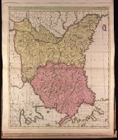
Appeared in Valk and Schenk's Atlantis sylloge compendiosa, ca. 1702., Backed with paper. Ms. no. "82" in upper left corner. Sheet measures 62.5 x 53.7 cm. No. 76 of 87 maps bound together., Bar scales given in "milliaria Hungarica" and "milliaria Germanica.", Prime meridian: Ferro., and Relief shown pictorially.
Publisher:
Gerard Valk,
Subject (Geographic):
Bulgaria--Maps--Early works to 1800., Romania--Maps--Early works to 1800., and Turkey--Maps--Early works to 1800.
Subject (Name):
Schenk, Peter, 1660-1718 or 1719. Atlantis sylloge compendiosa. and Valck, G. (Gerard), 1651 or 1652-1726. Atlantis sylloge compendiosa.
"Avec privil.", Backed with paper. Ms. no. "97" in upper right-hand corner. Sheet measures 53.6 x 63.5 cm. No. 87 of 87 maps bound together., Includes four bar scales., Includes inset: Carte particulière du Détroit de Magellan., Relief shown pictorially., and Untitled inset shows Southern Hemisphere.
Publisher:
Elizabeth Visscher,
Subject (Geographic):
Magellan, Strait of (Chile and Argentina)--Maps--Early works to 1800., South America--Maps--Early works to 1800., and Southern Hemisphere--Maps--Early works to 1800.
Backed with paper. Ms. no. "34" in upper left-hand corner. Sheet measures 53.6 x 62.9 cm. No. 33 of 87 maps bound together., Bar scales given in "milliaria Germanica" and "milliaria Gallica"., and Prime meridian: Ferro.
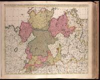
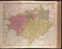
Appears in Valk and Schenk's Atlantis sylloge compendiosa, ca. 1702., Bar scales given in "milliaria Germanica communia" and "milliaria Gallica communia"., BEIN 1973 Folio 18: Imperfect: slight stains on verso and recto, with no loss of text. Backed with paper. Ms. no. in upper right corner: 22. Sheet measures 53.7 x 62.8 cm. No. 22 of 87 maps bound together., Prime meridian: Ferro., Relief shown pictorially., and Watermark.
Publisher:
Gerard Valck,
Subject (Geographic):
Germany, Northern--Maps--Early works to 1800.
Subject (Name):
Schenk, Peter, 1660-1718 or 1719. Atlantis sylloge compendiosa., Valck, G. (Gerard), 1651 or 1652-1726. Atlantis sylloge compendiosa., and Valck, Leonard, 1675-1746.
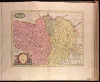
Appears in Valk and Schenk's Atlantis sylloge compendiosa, ca. 1702., Backed with paper. Ms. no. in upper right corner: 24. Sheet measures 53.7 x 62.7 cm. No. 24 of 87 maps bound together., Bar scales given in "milliaria Germanica communia" and "milliaria Gallica communia"., Prime meridian: Ferro., Relief shown pictorially., and Watermark.
Publisher:
Gerard Valck,
Subject (Geographic):
Brandenburg (Germany)--Maps--Early works to 1800., Saxony (Germany)--Maps--Early works to 1800., Saxony-Anhalt (Germany)--Maps--Early works to 1800., and Thuringia (Germany)--Maps--Early works to 1800.
Subject (Name):
Schenk, Peter, 1660-1718 or 1719. Atlantis sylloge compendiosa., Valck, G. (Gerard), 1651 or 1652-1726. Atlantis sylloge compendiosa., and Valck, Leonard, 1675-1746.
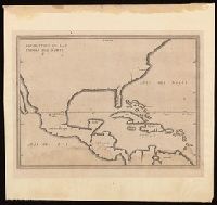
Appears in French eds. of Herrera y Tordesilla's Descripción de las Indias Occidentales published in Amsterdam., Sheet measures 28.7 x 35.2 cm. Cross Collection no. 227., and Shows coasts of the southern part of North America, Central America, northern coast of South America, and West Indies.
Publisher:
Michiel Colijn,
Subject (Geographic):
America--Maps--Early works to 1800., Central America--Maps--Early works to 1800., and West Indies--Maps--Early works to 1800.
Subject (Name):
Colijn, Michiel, publisher. and Herrera y Tordesillas, Antonio de, -1625. Descripción de las Indias Occidentales. French.
Bar scale given in "miglia sette.", Relief shown pictorially., and Sheet printed from cracked plate. Backed with paper. Ms. no. "72" in upper right corner. Sheet measures 53.7 x 62.6 cm. No. 67 of 87 maps bound together.
Publisher:
Joan Blaeu,
Subject (Geographic):
Parma (Italy : Province)--Maps--Early works to 1800. and Piacenza (Italy : Province)--Maps--Early works to 1800.
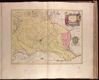
Backed with paper. Ms. no. "73" in upper right corner. Sheet measures 53.6 x 63.0 cm. No. 68 of 87 maps bound together., Bar scale given in "miglia sette d'Italia.", and Relief shown pictorially.
Publisher:
Joan Blaeu,
Subject (Geographic):
Milan (Italy : Province)--Maps--Early works to 1800.