Search
You Searched For
Search Results
- Creator:
- Lewis, Meriwether, 1774-1809
- Published / Created:
- undated
- Call Number:
- WA MSS 303
- Collection Title:
- Lewis and Clark Expedition maps and receipt, ca. 1803-1810
- Container / Volume:
- Box 1 | Folder 3r
- Image Count:
- 1
- Found in:
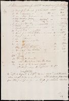
- Beinecke Rare Book and Manuscript Library > "A Memorandum of Articles in readiness for the Voyage," manuscript list
- Creator:
- Lewis, Meriwether, 1774-1809
- Published / Created:
- 1887].
- Call Number:
- 71 1806A
- Container / Volume:
- BRBL_00368
- Image Count:
- 1
- Resource Type:
- Maps, Atlases & Globes
- Found in:
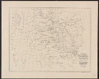
- Beinecke Rare Book and Manuscript Library > A map of part of the continent of North America : between the 35th and 51st degrees of north latitude, and extending from 80 degrees of west longitude to the Pacific Ocean / compiled from the authorities of the best informed travellers by M. Lewis ; copie
- Creator:
- Lewis, Meriwether, 1774-1809
- Call Number:
- WA MSS 303
- Collection Title:
- Lewis and Clark Expedition maps and receipt, ca. 1803-1810
- Container / Volume:
- Box 2 | Folder 46
- Image Count:
- 2
- Found in:
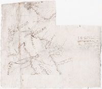
- Beinecke Rare Book and Manuscript Library > Area of the Mouth of the Columbia River, Northern Side
- Creator:
- Clark, William, 1770-1838.
Lewis, Meriwether, 1774-1809
- Published / Created:
- 1805?
- Call Number:
- WA MSS 303
- Collection Title:
- Lewis and Clark Expedition maps and receipt, ca. 1803-1810
- Container / Volume:
- Box 1 | Folder 25v
- Image Count:
- 1
- Found in:
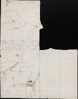
- Beinecke Rare Book and Manuscript Library > Area of the junction of the Medicine (Sun) and Missouri rivers and sketches of the falls of the Missouri, route about June-July 1805
- Creator:
- Clark, William, 1770-1838.
Lewis, Meriwether, 1774-1809
- Published / Created:
- 1805?
- Call Number:
- WA MSS 303
- Collection Title:
- Lewis and Clark Expedition maps and receipt, ca. 1803-1810
- Container / Volume:
- Box 1 | Folder 25r
- Image Count:
- 1
- Found in:
- Beinecke Rare Book and Manuscript Library > Area of the junction of the Musselshell and Missouri rivers, route about May 20, 1805 [and] Sketches of falls of the Missouri, route about June-July 1805
- Creator:
- Clark, William, 1770-1838.
Lewis, Meriwether, 1774-1809
- Published / Created:
- undated
- Call Number:
- WA MSS 303
- Collection Title:
- Lewis and Clark Expedition maps and receipt, ca. 1803-1810
- Container / Volume:
- Box 2 | Folder 46
- Image Count:
- 2
- Found in:
- Beinecke Rare Book and Manuscript Library > Area of the mouth of the Columbia River, northern side
- Creator:
- Clark, William, 1770-1838.
Lewis, Meriwether, 1774-1809
- Published / Created:
- undated
- Call Number:
- WA MSS 303
- Collection Title:
- Lewis and Clark Expedition maps and receipt, ca. 1803-1810
- Container / Volume:
- Box 2 | Folder 48
- Image Count:
- 2
- Found in:
- Beinecke Rare Book and Manuscript Library > Area of the mouth of the Columbia River, southern side
- Creator:
- Lewis, Meriwether, 1774-1809
- Published / Created:
- 1805
- Call Number:
- WA MSS 303
- Collection Title:
- Lewis and Clark Expedition maps and receipt, ca. 1803-1810
- Container / Volume:
- Box 1 | Folder 10v
- Image Count:
- 1
- Found in:
- Beinecke Rare Book and Manuscript Library > Big White's Map of 1805 by Clark
- Creator:
- Clark, William, 1770-1838.
Lewis, Meriwether, 1774-1809
- Published / Created:
- 1803?
- Call Number:
- WA MSS 303
- Collection Title:
- Lewis and Clark Expedition maps and receipt, ca. 1803-1810
- Container / Volume:
- Box 1 | Folder 3v
- Image Count:
- 1
- Found in:
- Beinecke Rare Book and Manuscript Library > Clark's Map of the Grand Tower, route about November 25, 1803
- Creator:
- Clark, William, 1770-1838.
Lewis, Meriwether, 1774-1809
- Published / Created:
- undated
- Call Number:
- WA MSS 303
- Collection Title:
- Lewis and Clark Expedition maps and receipt, ca. 1803-1810
- Container / Volume:
- Box 2 | Folder 47
- Image Count:
- 2
- Found in:
- Beinecke Rare Book and Manuscript Library > Coastline north of the mouth of the Columbia River