Search
You Searched For
Search Results
- Published / Created:
- 1786
- Call Number:
- 326 Ed43 1786
- Container / Volume:
- BRBL_00070
- Image Count:
- 1
- Resource Type:
- Maps, Atlases & Globes
- Found in:
- Beinecke Rare Book and Manuscript Library > A Plan of Edinburgh and the country adjacent ... by John Laurie ...
- Creator:
- Hamilton and Balfour (Edinburgh, Scotland)
Ruddiman, Thomas, 1674-1757
- Published / Created:
- Printed in the year [1758]
- Call Number:
- 2000 629
- Image Count:
- 53
- Found in:
- Beinecke Rare Book and Manuscript Library > A catalogue of a rare and valuable collection of books : being the whole library of the late Mr. Thomas Ruddiman ... to be sold by auction ... on Wednesday 1st February 1758 ...
- Creator:
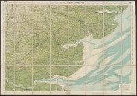
- Great Britain. War Office. General Staff. Topographical Section
- Published / Created:
- [1906?]
- Call Number:
- 6415 1906
- Container / Volume:
- BRBL_00338
- Image Count:
- 1
- Resource Type:
- Maps, Atlases & Globes
- Found in:
- Beinecke Rare Book and Manuscript Library > Africa 1:1 000 000. Nyasaland Protectorate [cartographic material].
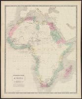
- Creator:
- Johnston, Alexander Keith, 1804-1871
- Published / Created:
- [c1849]
- Call Number:
- 60 1849C
- Container / Volume:
- BRBL_00326
- Image Count:
- 1
- Resource Type:
- Maps, Atlases & Globes
- Found in:
- Beinecke Rare Book and Manuscript Library > Africa [cartographic material] / by A.K. Johnston, F.R.G.S. ; engraved by W. & A.K. Johnston.
- Creator:
- Bartholomew, J. G. (John George), 1860-1920
Edinburgh Geographical Institute
- Published / Created:
- [1900?]
- Call Number:
- 3229 1900
- Container / Volume:
- BRBL_00063
- Image Count:
- 1
- Resource Type:
- Maps, Atlases & Globes
- Found in:
- Beinecke Rare Book and Manuscript Library > Bartholomew's "Half inch to mile" map of England & Wales. Sheet 12, Cheshire.
- Creator:
- Bartholomew, J. G. (John George), 1860-1920
Edinburgh Geographical Institute
- Published / Created:
- [1890?]
- Call Number:
- 3258 1890
- Container / Volume:
- BRBL_00069
- Image Count:
- 2
- Resource Type:
- Maps, Atlases & Globes
- Found in:
- Beinecke Rare Book and Manuscript Library > Bartholomew's "Half inch to mile" map of England & Wales. Sheet 25, Hertfordshire.
- Creator:
- Bartholomew, J. G. (John George), 1860-1920
Edinburgh Geographical Institute
- Published / Created:
- [19--?]
- Call Number:
- 3225 1900
- Container / Volume:
- BRBL_00060
- Image Count:
- 1
- Resource Type:
- Maps, Atlases & Globes
- Found in:
- Beinecke Rare Book and Manuscript Library > Bartholomew's "Half inch to mile" map of England & Wales. Sheet 26, Essex.
- Creator:
- John Bartholomew & Co
- Published / Created:
- [1890?]
- Call Number:
- 3213 1890
- Container / Volume:
- BRBL_00056
- Image Count:
- 2
- Resource Type:
- Maps, Atlases & Globes
- Found in:
- Beinecke Rare Book and Manuscript Library > Bartholomew's "half-inch to mile" map of England and Wales. Kent / the Edinburgh Geographical Institute ; John Bartholomew.
- Creator:
- John Bartholomew & Co
- Published / Created:
- [1890]
- Call Number:
- 3214 1890
- Container / Volume:
- BRBL_00056
- Image Count:
- 2
- Resource Type:
- Maps, Atlases & Globes
- Found in:
- Beinecke Rare Book and Manuscript Library > Bartholomew's "half-inch to mile" map of England and Wales. Sussex / the Edinburgh Geographical Institute ; John Bartholomew.
- Published / Created:
- 1920
- Call Number:
- 30fb 1920
- Container / Volume:
- BRBL_00037B
- Image Count:
- 2
- Resource Type:
- Maps, Atlases & Globes
- Found in:
- Beinecke Rare Book and Manuscript Library > Bartholomew's Political Map of the New Europe 1920 / According to treaties of Paris showing the old states of 1914 and the new of 1920.