Skip to search
Skip to main content
Skip to first result
Search
You Searched For
Publication Place
Edinburgh :
New Search
Search Results
Creator:
Published / Created:
1817
Call Number:
In H338 817
Image Count:
131
Description:
"All the papers, in the two volumes here offered to the public, were written by myself and Mr. Hunt, except a letter communicated by a friend in the seventeenth number." Advertisement, p. vi.
Publisher:
Printed Archibald Constable and co., and Longman, Hurst, Rees, Orme, and Brown, London,
Subject (Name):
Melville, Herman,--1819-1891--Ownership
Found in:
Beinecke Rare Book and Manuscript Library > The Round table: a collection of essays on literature, men, and manners ...
Creator:
Published / Created:
1817
Call Number:
In H338 817
Image Count:
139
Description:
"All the papers, in the two volumes here offered to the public, were written by myself and Mr. Hunt, except a letter communicated by a friend in the seventeenth number." Advertisement, p. vi.
Publisher:
Printed Archibald Constable and co., and Longman, Hurst, Rees, Orme, and Brown, London,
Subject (Name):
Melville, Herman,--1819-1891--Ownership
Found in:
Beinecke Rare Book and Manuscript Library > The Round table: a collection of essays on literature, men, and manners ...
Published / Created:
[1885?]
Call Number:
326 1885
Container / Volume:
BRBL_00070
Image Count:
1
Resource Type:
Maps, Atlases & Globes
Description:
Preliminary record.
Publisher:
A. & C. Black,
Subject (Geographic):
Scotland--Maps
Found in:
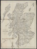
Beinecke Rare Book and Manuscript Library > The Tourist's map of Scotland. Constructed and engraved by J. Bartholomew.
Creator:
Published / Created:
[186-?]
Call Number:
55 1870
Container / Volume:
BRBL_00292
Image Count:
1
Resource Type:
Maps, Atlases & Globes
Description:
Relief indicated by hachures.
Publisher:
Blackie,
Subject (Geographic):
Asia, Central--Maps
Found in:
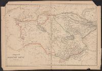
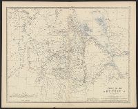
Beinecke Rare Book and Manuscript Library > Turkestan or Independent Tartary [cartographic material].
Creator:
Published / Created:
[1818?]
Call Number:
75 1818A
Container / Volume:
BRBL_00397
Image Count:
1
Resource Type:
Maps, Atlases & Globes
Description:
Col. Sheet measures 40.5 x 52 cm. and Relief shown by hachures.
Publisher:
W. & D. Lizars,
Subject (Geographic):
United States--Maps
Subject (Name):
Lizars, W. H. (William Home), 1788-1859
Found in:
Beinecke Rare Book and Manuscript Library > United States of America : drawn & engraved for Wardens Statistical Account, etc. / by W. & D. Lizars, Edinburgh.
Creator:
Published / Created:
[187-?]
Call Number:
615 187XB
Container / Volume:
BRBL_00332
Image Count:
1
Resource Type:
Maps, Atlases & Globes
Alternative Title:
Map of Upper Nubia and Abyssinia
Description:
Dissected and mounted on cloth, folded in cover 18 x 12., In top margin: Keith Johnston's General atlas. 40., and Relief shown by hachures.
Publisher:
W. Blackwood & Sons,
Subject (Geographic):
Africa, Eastern--Maps
Subject (Name):
Johnston, Alexander Keith, 1804-1871. Royal atlas of modern geography
Found in:
Beinecke Rare Book and Manuscript Library > Upper Nubia and Abyssinia / by Keith Johnston.
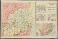
Creator:
Published / Created:
[1899?]
Call Number:
643 1899
Container / Volume:
BRBL_00340
Image Count:
1
Resource Type:
Maps, Atlases & Globes
Alternative Title:
Map to illustrate the Transvaal question, Transvaal question, and W. and A.K. Johnston's map to illustrate the Transvaal question
Description:
Book plate affixed "From the Estate of H.C. von Post. 1913"., Includes ancillary maps of "The world," "Africa," "Cape Town and environs," "Environs of Johannesburg," "Cape Town," and "South Africa.", and Relief shown by shading.
Publisher:
W. & A.K. Johnston,
Subject (Geographic):
Transvaal (South Africa)--Maps
Found in:
Beinecke Rare Book and Manuscript Library > W. & A.K. Johnston's map to illustrate the Transvaal question.
Published / Created:
[1910?]
Call Number:
30 1910
Container / Volume:
BRBL_00032
Image Count:
1
Resource Type:
Maps, Atlases & Globes
Description:
Insets: Berlin--Hamburg--Gibraltar--The Oresund--Petrograd--The Dardanelles-The Bosphorus.
Publisher:
John Bartholomew & Co.,
Subject (Geographic):
Europe--Maps
Found in:
Beinecke Rare Book and Manuscript Library > [Europe].
Branch:v1.61.8 ,Deployed:2024-06-20T11:15:02-04:00