Skip to search
Skip to main content
Skip to first result
Search
You Searched For
Language
English
Language
Latin
Creator
Homann, Johann Baptist, 1663-1724
New Search
Search Results
Creator:
Published / Created:
1715?
Call Number:
1975 Folio 31
Collection Title:
[Atlas factice of 42 maps, produced by the Homann Erben firm]
Image Count:
1
Publisher:
Johann Baptist Homann
Subject (Geographic):
Ireland --Maps --Early works to 1800
Subject (Topic):
Atlases, German --Early works to 1800
Collection Created:
[Nuremberg,
Found in:
Beinecke Rare Book and Manuscript Library > Hiberniae regnum tam in praecipuas Ultoniae, Connaciae, Laceniae et Momoniae [cartographic material] : quam in minores earundem provincias et ditiones divisum ex prototype Guil. Petty-Vischeriano deductu et exhibitum / a Joh. Bapt. Homanno
Creator:
Published / Created:
1729
Call Number:
1975 Folio 31
Collection Title:
[Atlas factice of 42 maps, produced by the Homann Erben firm]
Image Count:
1
Alternative Title:
General map of Great Britain and Ireland with part of Holland, Flanders France &c. agreable to modern history by the heirs of late Mr. Homann at Nuremburg, priviledged by Emperours Majesty
Publisher:
Homann Erben
Subject (Geographic):
Great Britain --Maps --Early works to 1800 and Ireland --Maps --Early works to 1800
Subject (Topic):
Atlases, German --Early works to 1800
Collection Created:
[Nuremberg,
Found in:
Beinecke Rare Book and Manuscript Library > Magna Britannia complectens Angliae, Scotiae, et Hyberniae regn [cartographic material] : in suas prov. et comitat. divisa et ex mappis Londinensibus designata / per Homannum
Creator:
Published / Created:
1715?
Call Number:
1975 Folio 31
Collection Title:
[Atlas factice of 42 maps, produced by the Homann Erben firm]
Image Count:
1
Publisher:
Johann Baptist Homann
Subject (Geographic):
Great Britain --Maps --Early works to 1800
Subject (Topic):
Atlases, German --Early works to 1800
Collection Created:
[Nuremberg,
Found in:
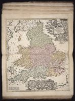
Beinecke Rare Book and Manuscript Library > Magnae Britanniae pars meridionalis in qua regnum Angliae tam in septem antiqua Anglo-Saxonum regna quom in omnes Hodiernas regiones accurate divisum hic ostenditur quam tabula ab archetypo Vischeriano desumptam exhibet / [cartographic material] / Ioh. Ba
Creator:
Published / Created:
[172-?]
Call Number:
1983 Folio 23
Collection Title:
[Atlas factice of 50 maps, primarily by Johann Baptist Homann and/or issued by the Homann Erben
Image Count:
1
Publisher:
[Johann Baptist Homann]
Subject (Geographic):
Great Britain --Maps --Early works to 1800
Collection Created:
[Nuremberg : Homann Erben, 1710-1786]
Found in:
Beinecke Rare Book and Manuscript Library > Magnae Britanniae pars meridionalis in qua regnum Angliae tam in septem antiqua Anglo-Saxonum regna quom in omnes Hodiernas regiones accurate divisum hic ostenditur quam tabula ab archetypo Vischeriano desumptam exhibet [cartographic material] / Ioh. Bapt
Creator:
Published / Created:
1715?
Call Number:
1975 Folio 31
Collection Title:
[Atlas factice of 42 maps, produced by the Homann Erben firm]
Image Count:
1
Publisher:
Johann Baptist Homann
Subject (Geographic):
Scotland --Maps --Early works to 1800
Subject (Topic):
Atlases, German --Early works to 1800
Collection Created:
[Nuremberg,
Found in:
Beinecke Rare Book and Manuscript Library > Magnae Britanniae pars septentrionalis qua regnum Scotiae [cartographic material] : in suas partes et subjacentes insulas divisum : accurata tabula ex archetypo Vischeriano desumta exhibetur imitatore / Johan. Bapt. Homanno
Creator:
Published / Created:
1749
Call Number:
1973 Folio 30
Collection Title:
[Atlas factice of 32 maps and 1 distance table, produced by the Homann Erben firm]
Image Count:
1
Alternative Title:
General map of Great Britain and Ireland with part of Holland Flandres France &c. agreable to modern history by the heirs of late Mr. Homann at Nueremburg 1749, priviledged by Emperours Majesty
Publisher:
Edentibg. Homan[n]ianis heredibus
Subject (Geographic):
Great Britain --Maps --Early works to 1800 and Ireland --Maps --Early works to 1800
Subject (Topic):
Atlases, German --Early works to 1800
Collection Created:
[Nuremberg : s.n., 1701-1760]
Found in:
Beinecke Rare Book and Manuscript Library > Regnorum Magnae Britanniae et Hiberniae mappa geographica : iuxta observationes astronomicas recentiores denuo correcta et ad formam legitimae projectionis reducta a Tobia Majero
Creator:
Published / Created:
ca. 1714]
Call Number:
755 1759
Container / Volume:
BRBL_00728
Image Count:
1
Resource Type:
Maps, Atlases & Globes
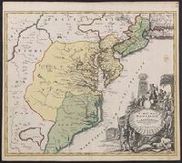
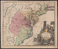
Description:
Also covers Delaware, southern Pennsylvania, New Jersey, western Long Island, southwestern Connecticut, and portions of adjacent areas., Bar scale given in "milliaria Germanica"., First appe, Includes ill., and Relief shown pictorially. Depths shown by soundings.
Publisher:
[Johann Baptist Homann?,
Subject (Geographic):
Atlantic States--Maps--Early works to 1800
Subject (Name):
Homann, Johann Baptist, 1663-1724. Atlas novus
Found in:
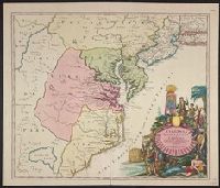
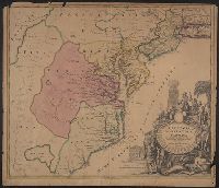
Beinecke Rare Book and Manuscript Library > Virginia, Marylandia et Carolina in America septentrionali Brittannorum industria excultae / repraesentatae à Ioh. Bapt. Homann, S.C.M. Geog.
Creator:
Published / Created:
ca. 1714]
Call Number:
755 1714
Container / Volume:
BRBL_00425
Image Count:
1
Resource Type:
Maps, Atlases & Globes
Description:
Annotated "157" in black ink, in top margin and on verso. Hand col. Sheet m and First appeared in Homann's Atlas novus.
Publisher:
[Johann Baptist Homann?,
Subject (Geographic):
Atlantic States--Maps--Early works to 1800
Subject (Name):
Homann, Johann Baptist, 1663-1724. Atlas novus
Found in:
Beinecke Rare Book and Manuscript Library > Virginia, Marylandia et Carolina in America septentrionali Brittannorum industria excultae / repraesentatae à Ioh. Bapt. Homann, S.C.M. Geog.
Creator:
Published / Created:
ca. 1714]
Call Number:
755 1714B
Container / Volume:
BRBL_00425
Image Count:
1
Resource Type:
Maps, Atlases & Globes
Description:
Also covers Delaware, southern Pennsylvania, New Jersey, western Long Island, southwestern Connecticut, and portions of adjacent areas., Bar scale given in "milliaria Germanica"., Includes ill., Relief shown pictorially. Depths shown by soundings., and Title in L
Publisher:
[Johann Baptist Homann?,
Subject (Geographic):
Atlantic States--Maps--Early works to 1800
Subject (Name):
Homann, Johann Baptist, 1663-1724. Atlas novus
Found in:
Beinecke Rare Book and Manuscript Library > Virginia, Marylandia et Carolina in America septentrionali Brittannorum industria excultae / repraesentatae à Ioh. Bapt. Homann, S.C.M. Geog.
Creator:
Published / Created:
ca. 1730]
Call Number:
783 1759
Container / Volume:
BRBL_00691
Image Count:
1
Resource Type:
Maps, Atlases & Globes
Description:
Also covers Delaware, southern Pennsylvania, New Jersey, western Long Island, southwestern Connecticut, and portions of adjacent areas., Bar scale given in "milliaria Germanica"., Includes ill., Prime meri, and Relief shown pictorially. Depths shown by soundings.
Publisher:
[Johann Baptist Homann,
Subject (Geographic):
Atlantic States--Maps--Early works to 1800
Found in:
Beinecke Rare Book and Manuscript Library > Virginia, Marylandia et Carolina in America septentrionali Brittannorum industria excultæ / repraesentatae à Ioh. Bapt. Homann, S.C.M. Geog.
Branch:v1.61.8 ,Deployed:2024-06-20T11:15:02-04:00