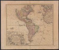
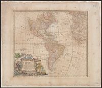
Lists "Falkland" below I. Malouines. In other states of this map, the name "Falkland" no longer appears., Relief shown pictorially., and The Yale map collection also has two other states of this map, one state differs in that it has following after the last line of text (and before the date) in the title cartouche: "Cum Privil S.C.M." . The call number is *70.1746A. The other state differs in that it has listed below the neat line the name of the engraver "Seb. Dorn sc." This call number is *70.1746 copy 1. Cross collection no. 131.
Publisher:
in lucem proferentibus Homannianis Heridibus,
Subject (Geographic):
Western Hemisphere--Maps--Early works to 1800
Subject (Name):
Boehme, August Gottlieb, 1719-1797 and Hase, Johann Matthias, 1684-1742
Imperfect: chewed along edges, with no loss of text. Without privilege statement of engraver statement, but with "Falkland" below I. Malouines (off the southern coast of Argentia). Stamp on verso: Yale University Library, Karpinski-Von Wieser Map Collecti
Publisher:
in lucem proferentibus Homannianis Heridibus,
Subject (Geographic):
America--Maps--Early works to 1800 and Western Hemisphere--Maps--Early works to 1800
Subject (Name):
Boehme, August Gottlieb, 1719-1797 and Hase, Johann Matthias, 1684-1742
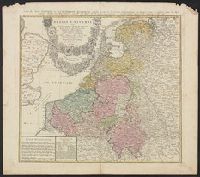
Carte des XVII. provinces ou de l'Allemagne inferievre, dresseé suivant la projection stereographique, et appüyée par les mesures faites de Mess. Cassini, Snellius et Mouschenbrok, par Mr. Tob. Majer de la Societé geographique, et publiée par les Her
Description:
Includes coat-of-arms and 5 bar scales., Relief shown pictorially., Sheet measures 54.6 x 61.5 cm., and Title in Latin and French; legend in Latin.
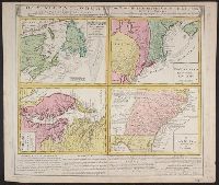
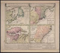
Gros-Britannische Colonie-Lænder in Nord-America, in accuraten Special-Mappen nach den London. Originalien gretreulich mitgetheilt und heraussgegeben von Homaennischen Erben
Description:
A. New Foundland od. Terra Nova, S. Laurentii Bay, die Fisch-Bank, Acadia, nebst einem Theil New Schotland -- B. New Engelland, New York, New Yersey und Pensilvania -- C. Virginia und Maryl, Consists of four maps on one plate., and In Latin, German and English.
Publisher:
Homannianis Hered.,
Subject (Geographic):
Atlantic Coast (Canada)--Maps--Early works to 1800, Atlantic Coast (U.S.)--Maps--Early works to 1800, and Great Britain--Colonies--America--Maps--Early works to 1800
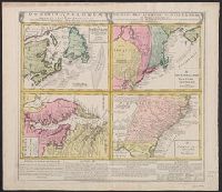
Gros-Britannische Colonie-Lænder in Nord-America, in accuraten Special-Mappen nach den London. Originalien gretreulich mitgetheilt und heraussgegeben von Homaennischen Erben
Description:
"Mit Kayserl. allergn. Privil." and A. New Foundland od. Terra Nova, S. Laurentii Bay, die Fisch-Bank, Acadia, nebst einem Theil New Schotland -- B. New Engelland, New York, New Yersey und Pensilvania -- C. Virginia und Maryland -- D. Carolina nebst einem The
Publisher:
Homannianis Hered.,
Subject (Geographic):
Atlantic Coast (Canada)--Maps--Early works to 1800, Atlantic Coast (U.S.)--Maps--Early works to 1800, and Great Britain--Colonies--America--Maps--Early works to 1800
Gros-Britannische Colonie-Lænder in Nord-America, in accuraten Special-Mappen nach den London. Originalien gretreulich mitgetheilt und heraussgegeben von Homaennischen Erben
Description:
A. New Foundland od. Terra Nova, S. Laurentii Bay, die Fisch-Bank, Acadia, nebst einem Theil New Schotland -- B. New Engelland, New York, New Yersey und Pensilvania -- C. Virgin, In Latin, German and English., and Sheet measures 56 x 64 cm. Franklin Collection.
Publisher:
Homannianis Hered.,
Subject (Geographic):
Atlantic Coast (Canada)--Maps--Early works to 1800, Atlantic Coast (U.S.)--Maps--Early works to 1800, and Great Britain--Colonies--America--Maps--Early works to 1800
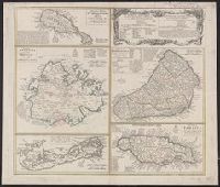
Cross Collection no. 245., Imperfect: map of Jamaica cut-out. Two maps (Antigua and Barbados)., Includes explanatory notes and index., Relief shown pictorially., Scales in millaria Anglica communia and/or millaria Anglica statuta., and Sheet title in Latin and German. Individual map titles and text in German. Maps in English and German.
Publisher:
Homann Erben,
Subject (Geographic):
Antigua--Maps--Early works to 1800, B, Barbados--Maps--Early works to 1800, Jamaica--Maps--Early works to 1800, Saint Kitts and Nevis--Maps--Early works to 1800, and West Indies--Maps--Early works to 1800
Cross Collection no. 253., Includes explanatory notes and index., Ms. notes in upper right corner., Relief shown pictorially., Scales in millaria Anglica communia and/or millaria Anglica statuta., Sheet title in Latin and German. Individual map titles and text in German. Maps in English and German., and Three maps (Antigua, Barbados, Jamaica). Mounted on linen.
Publisher:
Homann Erben,
Subject (Geographic):
Antigua--Maps--Early works to 1800, Barbados--Maps--Early works to 1800, Bermuda Islands--Maps--Early works to 1800, Jamaica--Maps--Early works to 1800, and Saint Kitts and Nevis--Maps--Early works to 1800
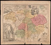
Imperfect: mutilated along fold, with some loss of text; chipped. Manuscript number in upper right corner: 4. From the Karpinski-von Wieser Map Collection., Includes illustration and inset: Appendix monasteriorum Ord. S. Bened. quae extant in Polonia et Lithuania., Relief shown pictorially., and Shows location of Benedictine monasteries in Holy Roman Empire, Poland, and Lithuania.
Publisher:
[Homann Erben]
Subject (Geographic):
Europe, Central and Germany
Subject (Topic):
Benedictine monasteries--Europe, Central--Maps--Early works to 1800, Benedictine monasteries--Germany--Maps--Early works to 1800, Monasteries--Europe, Central--Maps--Early works to 1800, and Monasteries--Germany--Maps--Early w