Skip to search
Skip to main content
Skip to first result
Search
You Searched For
Resource Type
Maps, Atlases & Globes
Language
Latin
New Search
Search Results
Creator:
Published / Created:
[163-?]
Call Number:
1973 Folio 18
Image Count:
1
Resource Type:
Maps, Atlases & Globes
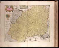
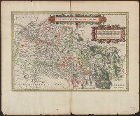
Alternative Title:
Langvedoc
Description:
Backed with paper. Ms. no. "53" in upper-right corner. Sheet measures 53.7 x 62.8 cm. No. 48 of 87 maps bound together., Bar scale given in "milliaria Gallica"., Prime meridian: Ferro., Relief shown pictorially., and Watermark.
Publisher:
Guiljemus Blaeuw excudit,
Subject (Geographic):
Languedoc (France)--Maps--Early works to 1800.
Found in:
Beinecke Rare Book and Manuscript Library > Languedoc [cartographic material].
Creator:
Published / Created:
[1635]
Call Number:
388 1635
Container / Volume:
BRBL_00182
Image Count:
2
Resource Type:
Maps, Atlases & Globes
Alternative Title:
Langvedoc
Description:
Bar scale given in "milliaria Gallica"., Imperfect: sheet torn on left side, with no loss of text. Sheet measures 50.5 x, In Latin on verso, with caption title "Languedocia, vulgo Languedoc" and signature H., Prime meridian: Ferro., and Relief shown pictorially.
Publisher:
Guiljemus Blaeuw excudit,
Subject (Geographic):
Languedoc (France)--Maps--Early works to 1800
Found in:
Beinecke Rare Book and Manuscript Library > Languedoc [cartographic material].
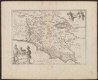
Creator:
Published / Created:
1652?]
Call Number:
400 L39 1652
Container / Volume:
BRBL_00233
Image Count:
1
Resource Type:
Maps, Atlases & Globes
Description:
Annotated in black ink in upper left margin: Tab. 32., Appears in the author's Accuratissima orbis antiqui delineatio., and Relief shown pictorially.
Publisher:
J. Jansson,
Subject (Geographic):
Lazio (Italy)--Historical Geography--Maps--Early works to 1800 and Lazio (Italy)--Maps--Early works to 1800
Subject (Name):
Jansson, Jan, 1588-1664. Accuratissima orbis antiqui delineatio
Found in:
Beinecke Rare Book and Manuscript Library > Latium.
Creator:
Published / Created:
1652?]
Call Number:
406 1652A
Container / Volume:
BRBL_00236
Image Count:
1
Resource Type:
Maps, Atlases & Globes
Alternative Title:
Lativm
Description:
From the author's Accuratissima orbis antiqui delineatio., Relief shown pictorially., and Sheet measures 50 x 62 cm. Recto: Ms. "17".
Publisher:
J. Jansson,
Subject (Geographic):
Lazio (Italy)--Maps--Early works to 1800
Subject (Name):
Jansson, Jan, 1588-1664. Accuratissima orbis antiqui delineatio
Found in:
Beinecke Rare Book and Manuscript Library > Latium.
Published / Created:
[1660?]
Call Number:
3818 1660
Container / Volume:
BRBL_00174
Image Count:
2
Resource Type:
Maps, Atlases & Globes
Description:
Verso: Text.
Subject (Geographic):
Sarthe (France)--Maps--Early works to 1800
Found in:
Beinecke Rare Book and Manuscript Library > Le Pays & Diocese de Mans. Vulgairement le Maine ubi olim Cenomanni.
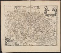
Published / Created:
1635?]
Call Number:
3916 1635
Container / Volume:
BRBL_00193
Image Count:
2
Resource Type:
Maps, Atlases & Globes
Alternative Title:
Legionis regnvm et Astvriarvm principatvs
Description:
Latin on recto, verso., Signature on verso: D., and Title on verso: Legio & Asturia.
Publisher:
Blaeu,
Subject (Geographic):
León (Spain : Province)--Maps--Early works to 1800
Found in:
Beinecke Rare Book and Manuscript Library > Legionis regnum et Asturiarum principatus.
Published / Created:
[1635?]
Call Number:
3867 1635
Image Count:
2
Resource Type:
Maps, Atlases & Globes
Description:
Verso: Text.
Publisher:
G. Bleauw,
Subject (Geographic):
Haute-Vienne (France)--Maps--Early works to 1800
Found in:
Beinecke Rare Book and Manuscript Library > Lemouicum, Auctore Jo Faiano M.L. Lymosin.
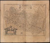
Published / Created:
[1635?]
Call Number:
335 1635
Container / Volume:
BRBL_00085
Image Count:
2
Resource Type:
Maps, Atlases & Globes
Description:
Latin on recto, verso., Oriented with north to the right., Signature on verso: K., and Title on verso: Leodiensis episcopatus.
Publisher:
Apud Guiljelmum et Ioannem Blaeu,
Subject (Geographic):
Belgium--Maps--Early works to 1800
Found in:
Beinecke Rare Book and Manuscript Library > Leodiensis dioecesis [cartographic material].
Published / Created:
1630?]
Call Number:
335 1630
Container / Volume:
BRBL_00085
Image Count:
2
Resource Type:
Maps, Atlases & Globes
Description:
Latin on recto, verso., Pg. nos. on verso: 252-253., Signature on verso: Sffff., and Title on verso: Leodiensis dioecesis.
Subject (Geographic):
Belgium--Maps--Early works to 1800
Found in:
Beinecke Rare Book and Manuscript Library > Leodiensis dioecesis typus / Baptista Doctecomius sculp.
Published / Created:
[18--?]
Call Number:
69J 18XX
Container / Volume:
BRBL_00352
Image Count:
1
Resource Type:
Maps, Atlases & Globes
Description:
From: Geogr. gr. min. Ed. Didot. Vol 1. Pl. XXI.
Subject (Geographic):
Libya--Maps--Early works to 1800
Found in:
Beinecke Rare Book and Manuscript Library > Libyae ora maritima. C. Muller descr.
Branch:v1.61.6 ,Deployed:2024-06-12T09:55:36-04:00