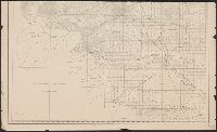
Map of Yakima Region, Washington Ter., western sheet
Description:
"Photolithographed preliminary sheet for the use of the parties in the field, and subject to revision.", In top margin: Western sheet., and Relief shown by contours and spot heights.
Publisher:
Northern Transcontinental Survey?],
Subject (Geographic):
Yakima River Valley (Wash.)--Maps, Topographic
Subject (Name):
Goode, Richard Urquhart, 1858-1903, Julius Bien & Co, Northern Transcontinental Survey, Owen, F. D, and Tweedy, Frank, 1854-1937
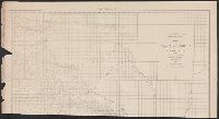
Map of Yakima Region, Washington Ter., eastern sheet
Description:
"Photolithographed preliminary sheet for the use of the parties in the field, and subject to revision.", "There is a slight discordance in projecting the U.S. Land Survey upon this map. A part of the S.W. corner is taken from the U.S. Land Office plats.", and n top margin: Eastern sheet.
Publisher:
Northern Transcontinental Survey?],
Subject (Geographic):
Yakima River Valley (Wash.)--Maps, Topographic
Subject (Name):
Goode, Richard Urquhart, 1858-1903, Julius Bien & Co, Northern Transcontinental Survey, Owen, F. D, and Tweedy, Frank, 1854-1937
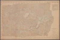
Lake Itasca basin, Minnesota, within Itasca State Park
Description:
" ... Topography by W.G. Comber, G.H. French and F.G. Ray. Hydrography by W.G. Comber. Office reduction, under the direction of C.W. Clark ... by A.T. Morrow, W.G. Comber, G.H. French, E.L. Harman, W.S. Williams, F.G. Ray, and Geo. H. Wolbrecht. Drawing,
Publisher:
s.n.,
Subject (Geographic):
Itasca State Park (Minn.)--Maps and Itasca, Lake (Minn.)--Maps
Subject (Name):
Clark, C. W, Comber, W. G, D'Ailly, H. A. H, French, G. H, Harmon, E. L, Julius Bien & Co, Morrow, A. T, Ray, F. G, Widen, K. A, and Williams, W. S