China Road Map 1:1,000,000, Series (Standard map series designation system) ; 301., and Series ; 301
Description:
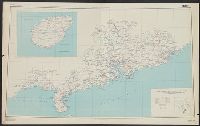
"2-45.", "Compiled in 1944, from large-scale Chinese maps. Road classification based on Intelligence Reports, 1944.", "Kwangtung, China" in bottom right corner., Includes inset map indexed to political divisions and glossary., and Relief shown by altitude tints,
"A.M.S. 5301.", Cloth map (silk)., For further information see a Web site devoted to the history and identification of the AAF cloth maps., Heights and depths in meters., Includes: Index to boundarie, and Relief shown by gradient tints, contours, and spot heights.
Publisher:
Amy Map Service,
Subject (Geographic):
East Asia--Maps
Subject (Name):
United States. Army Map Service
Subject (Topic):
Military geography--Japan--Kagoshima--Maps, Military geography--Japan--Nagasaki--Maps, Military maps, Military topography--Japan--Kagoshima--Maps, and Military topography--Japan--Nagasaki--Maps