Skip to search
Skip to main content
Skip to first result
Search
You Searched For
Resource Type
Maps, Atlases & Globes
Creator
Wyld, James, 1812-1887
New Search
Search Results
Creator:
Published / Created:
1874
Call Number:
642GBC 1874
Container / Volume:
BRBL_00339
Image Count:
1
Resource Type:
Maps, Atlases & Globes
Alternative Title:
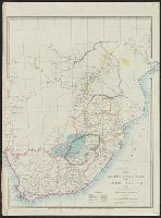
Diamond and gold fields of South Africa
Description:
Covers South Africa and Zimbabwe., In top margin: 34., and Relief shown by hachures.
Publisher:
J. Wyld,
Subject (Geographic):
South Africa--Maps and Zimbabwe--Maps
Subject (Topic):
Diamond mines and mining--South Africa--Maps, Diamond mines and mining--Zimbabwe--Maps, Gold mines and mining--South Africa--Maps, and Gold mines and mining--Zimbabwe--Maps
Found in:
Beinecke Rare Book and Manuscript Library > Adamantia, the diamond and gold fields of South Africa / by James Wyld.
Creator:
Published / Created:
[1852?]
Call Number:
44 1852
Container / Volume:
BRBL_00255
Image Count:
1
Resource Type:
Maps, Atlases & Globes
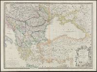
Description:
Relief shown pictorially. and Shows "railways completed."
Publisher:
Js. Wyld,
Subject (Geographic):
Balkan Peninsula--Maps and Turkey--Maps
Subject (Topic):
Railroads--Balkan Peninsula--Maps and Railroads--Turkey--Maps
Found in:
Beinecke Rare Book and Manuscript Library > European dominions of the Ottomans, or Turkey in Europe.
Creator:
Published / Created:
[1854?]
Call Number:
70 1854
Container / Volume:
BRBL_00359
Image Count:
1
Resource Type:
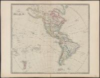
Maps, Atlases & Globes
Description:
Date below publisher statement erased. Date inferred from listing on p. 113 of Phillips, Maps of America, as map 57 in Wyld's New general atlas. [1854], Library's copy stamped on verso: Yale University Library, Karpinski-Von Wieser Map Collection., and Prime me
Publisher:
James Wyld, geographer to Her Majesty, Charing Cross East,
Subject (Geographic):
Western Hemisphere--Maps
Found in:
Beinecke Rare Book and Manuscript Library > Map of America.
Creator:
Published / Created:
1840
Call Number:
50 1870A
Container / Volume:
BRBL_00272
Image Count:
1
Resource Type:
Maps, Atlases & Globes
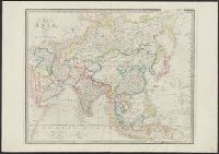
Description:
col. photocopy. and Relief shown by hachures.
Publisher:
Published by Js. Wyld, Geographer to Her Majesty ...,
Subject (Geographic):
Asia--Maps
Found in:
Beinecke Rare Book and Manuscript Library > Map of Asia.
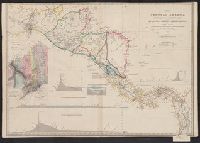
Creator:
Published / Created:
[1852?]
Call Number:
89 1852
Container / Volume:
BRBL_00657
Image Count:
1
Resource Type:
Maps, Atlases & Globes
Description:
Includes inset of "Isthmus of Panamma," 5 relief profiles, notes, and list of "Length of proposed routes." and Relief shown by hachures.
Publisher:
Published by James Wyld ...,
Subject (Geographic):
Central America--Maps, Panama, Isthmus of (Panama)--Maps, and Tehuantepec, Isthmus of (Mexico)--Maps
Found in:
Beinecke Rare Book and Manuscript Library > Map of Central America, shewing the different lines of Atlantic & Pacific communication / by James Wyld, geographer to the Queen.
Creator:
Published / Created:
[1854?]
Call Number:
71 1854A
Container / Volume:
BRBL_00371
Image Count:
1
Resource Type:
Maps, Atlases & Globes
Description:
Appears in Wyld's New general atlas. London, 1854. Cf. Phillips, Maps of America, p. 607., In upper right margin: 36., Relief shown by hachures., and Yale's copy stamped on verso: Yale University Library, Karpinski-Von Wieser Map Collection.
Publisher:
James Wyld, Charing Cross East,
Subject (Geographic):
North America--Maps
Subject (Name):
Stockley, S
Found in:
Beinecke Rare Book and Manuscript Library > Map of North America : exhibiting the recent discoveries, geographical & nautical / by James Wyld, Geographer to Her Majesty ; J.W. del. ; Stockley fc.
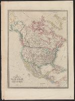
Creator:
Published / Created:
[1828]
Call Number:
71 1828
Container / Volume:
BRBL_00369
Image Count:
7
Resource Type:
Maps, Atlases & Globes
Description:
Date beneath publisher statement: March 1st 1827., Includes notes., Relief shown by hachures., Some sheets: Published by Jas. Wyld (successor to W. Faden, and Stevens and Tree describe the various issues of this map in Tooley's Mapping of America, p. 91., no. 63.
Publisher:
Jas. Wyld,
Subject (Geographic):
North America--Maps
Found in:
Beinecke Rare Book and Manuscript Library > Map of North America : exhibiting the recent discoveries, geographical and nautical; drawn chiefly from the authorities of M. de Humbolt, Lieutt. Pike, Messrs. Lewis and Clarke, Sir Alexr. Mackenzie, Mr. Hearne, Coll. Bouchette, Captns. Vancouver, Ross, P
Creator:
Published / Created:
[187-?]
Call Number:
71 1870A
Container / Volume:
BRBL_00371
Image Count:
1
Resource Type:
Maps, Atlases & Globes
Description:
Includes notes. and Relief shown by hachures.
Publisher:
Jas. Wyld, Charing Cross East, 457 Strand & 2 Royal Exchange,
Subject (Geographic):
North America--Maps
Found in:
Beinecke Rare Book and Manuscript Library > Map of North America : exhibiting the recent discoveries, geographical and nautical; drawn chiefly from the authorities of M. de Humbolt, Lieutt. Pike, Messrs. Lewis and Clarke, Sir Alexr. Mackenzie, Mr. Hearne, Coll. Bouchette, Captns. Vancouver, Ross, P
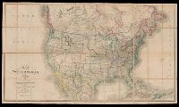
Creator:
Published / Created:
[1853]
Call Number:
26 1852
Container / Volume:
BRBL_00022
Image Count:
1
Resource Type:
Maps, Atlases & Globes
Description:
Dating: 1853 -Wyld's new address; before 1854, as Victorian railways not shown., Hand col. Mounted on linen. Sheet measures 68 x 101 cm., and Map of southern Australia with notes on the topography and gold deposits marked. Relief shown by hachures and
Publisher:
Published by Jas. Wyld, Geographer to the Queen, Charing Cross East ... & Model of the Earth, Leicester Square,
Subject (Geographic):
New South Wales--Maps, South Australia--Maps, Tasmania--Maps, and Western Australia--Maps
Found in:
Beinecke Rare Book and Manuscript Library > Map of South Australia, New South Wales, Van Diemens Land, and settled parts of Australia [cartographic material] / respectfully dedicated to Major Sir T.L. Mitchell Kt. D.C.L. F.G.S. &c Surveyor General of New South Wales by ... James Wyld.
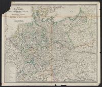
Creator:
Published / Created:
[1875?]
Call Number:
36 1875
Container / Volume:
BRBL_00120
Image Count:
1
Resource Type:
Maps, Atlases & Globes
Publisher:
James Wyld,
Subject (Geographic):
Germany--Maps and Prussia (Germany)--Maps
Found in:
Beinecke Rare Book and Manuscript Library > Map of the Germanic confederated states : including the kingdoms of Prussia, and the empire of Germany / James Wyld.
Branch:v1.61.6 ,Deployed:2024-06-12T09:55:19-04:00