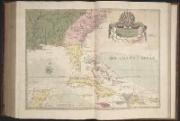
The American military pocket atlas : being an approved collection of correct maps, both general and
Image Count:
1
Description:
Augst. 5th. 1776., Inset: A particular plan of Lake George. surveyed in 1756. By Capt. Jackson., and Teaching resource: Professor John Mack Faragher, History 141: The American West.
Publisher:
Printed for Robt. Sayer & Jno. Bennett, Map & Sea Chartsellers No. 53 Fleet Street, as the Act directs
Subject (Geographic):
North America --Maps --Early works to 1800 and United States --History --Revolution, 1775-1783 --Maps
Collection Created:
London : Printed for R. Sayer and J. Bennet, [1776]
The natural history of Carolina, Florida, and the Bahama Islands : containing the figures of birds
Image Count:
1
Description:
Following p. 100.
Subject (Geographic):
Bahamas --Natural history, Florida --Natural history, North Carolina --Natural history, and South Carolina --Natural history
Subject (Topic):
Natural history --Bahamas, Natural history --North Carolina, Natural history --Pictorial works, Natural history --Pre-Linnean works, Natural history --South Carolina, and Natural history --Southern States
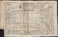
Papers relating to an act of the Assembly of the province of New-York, for encouragement of the
Image Count:
1
Alternative Title:
Map of the countrey of the Five Nations belonging to the province of New York and of the lakes near which the nations of far Indians live with part of Canada
Description:
Formerly bound preceding p. 1 of 2003 +64, now shelved separately as: Broadsides 2008 48.
Subject (Geographic):
Great Britain --Colonies --Commerce, Great Britain. Board of Trade, Great Britain. Sovereign (1714-1727 : George I), New York (State) --Commerce, New York (State) --Maps --Early works to 1800, New York (State). Act for encouragement of the Indian trade, and New York (State). Council
Subject (Name):
Colden, Cadwallader, 1688-1776 and L’Isle, Guillaume de, 1675-1726
Subject (Topic):
Fur trade --Canada, Fur trade --New York (State), and Indians of North America --Commerce
Collection Created:
[New York] : Printed and sold by William Bradford in the city of New-York, 1724
A topographical description of the Western territory of North America; containing a succinct
Image Count:
1
Description:
Engrav'd for S. Campbell's Edition of Imlay's Description of Kentucky., Facing p. 111., and Teaching resource: Professor John Mack Faragher, History 141: The American West.
Subject (Geographic):
Genesee River Valley (Pa. and N.Y.) --Early works to 1800, Mississippi River Valley --Description and travel --Early works to 1800, Mississippi River Valley --History --To 1803, and Ohio River Valley --Description and travel -
Subject (Name):
Filson, John, ca. 1747-1788 Discovery, settlement, and present state of Kentucky, Toulmin, Harry, 1766-1823 Thoughts on emigration, and United States. Dept. of State
Subject (Topic):
Public lands --United States --Early works to 1800
Collection Created:
New-York, Printed by Samuel Campbell, No. 37, Hanover Square, M,DCC,XCIII
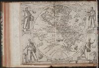
Americae pars sexta, sive, Historiae ab Hieronymo Be[n]zono Mediolane[n]se scriptae, sectio tertia
Image Count:
1
Subject (Geographic):
America --Early accounts to 1600, Canary Islands --Description and travel --Early works to 1800, Florida --History --Huguenot colony, 1562-1565, Peru --History --Conquest, 1522-1548, and Western Hemisphere --Maps --
Subject (Name):
Benzoni, Girolamo, b. 1519. Historia del Mondo Nuovo. Book 3. Latin and Bry, Theodor de, 1528-1598