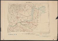
Manuscript documents and letters, illustrating the daily life and responsibilities of sea captains in the 18th and early 19th centuries. The collection includes documents relating to Captain Robert Poultney in Jamaica and letters on personal and naval matters addressed to Captain John Wainwright. Also included are descriptions of coastal areas and navigation hazzards, documents relating to obtaining supplies, a ship's newsletter, and a colored map ("Rochfort et les Environs").
Description:
Robert Poultney was the captain of the ship Loretta in Jamaica in 1762-1764., John Wainwright of the Royal Navy served in the East Indies and the Mediterranean, fought throughout the Napoleonic Wars, and is remembered for the destruction of the pirate town Ras-al-Kayma while captain of the ship Chiffonne., and In English, with one letter in French.
Subject (Geographic):
Mediterranean Region and Brittany (France)
Subject (Name):
Poultney, Robert., Wainwright, John, Captain., Chiffonne (Ship), Great Britain. Royal Navy, and Loretta (Ship)
Subject (Topic):
Officers, Sea life, Aids to navigation, Coasts, Navigation, Seafaring life, Ship captains, and Description and travel
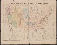
Beaumont, Texas, City of Port Arthur, Texas, Map of Beaumont, Texas, Map, city of Port Arthur, Texas, and Welcome to Beaumont
Description:
"Map, city of Port Arthur, Texas," index, text, and list of points of interest on verso., Includes index and inset of Multimax Central Park area., and On panel: Combest Incorporated, realtors.
Publisher:
Frank B. Dolph Co.,
Subject (Geographic):
Beaumont (Tex.)--Maps and Port Arthur (Tex.)--Maps
Subject (Name):
Combest
Subject (Topic):
Streets--Texas--Beaumont--Maps and Streets--Texas--Port Arthur--Maps
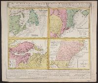
Gros-Britannische Colonie-Lænder in Nord-America, in accuraten Special-Mappen nach den London. Originalien gretreulich mitgetheilt und heraussgegeben von Homaennischen Erben
Description:
A. New Foundland od. Terra Nova, S. Laurentii Bay, die Fisch-Bank, Acadia, nebst einem Theil New Schotland -- B. New Engelland, New York, New Yersey und Pensilvania -- C. Virginia und Maryl, Consists of four maps on one plate., and In Latin, German and English.
Publisher:
Homannianis Hered.,
Subject (Geographic):
Atlantic Coast (Canada)--Maps--Early works to 1800, Atlantic Coast (U.S.)--Maps--Early works to 1800, and Great Britain--Colonies--America--Maps--Early works to 1800
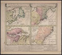
Gros-Britannische Colonie-Lænder in Nord-America, in accuraten Special-Mappen nach den London. Originalien gretreulich mitgetheilt und heraussgegeben von Homaennischen Erben
Description:
"Mit Kayserl. allergn. Privil." and A. New Foundland od. Terra Nova, S. Laurentii Bay, die Fisch-Bank, Acadia, nebst einem Theil New Schotland -- B. New Engelland, New York, New Yersey und Pensilvania -- C. Virginia und Maryland -- D. Carolina nebst einem The
Publisher:
Homannianis Hered.,
Subject (Geographic):
Atlantic Coast (Canada)--Maps--Early works to 1800, Atlantic Coast (U.S.)--Maps--Early works to 1800, and Great Britain--Colonies--America--Maps--Early works to 1800
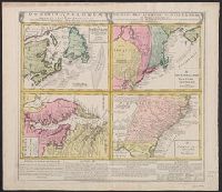
Gros-Britannische Colonie-Lænder in Nord-America, in accuraten Special-Mappen nach den London. Originalien gretreulich mitgetheilt und heraussgegeben von Homaennischen Erben
Description:
A. New Foundland od. Terra Nova, S. Laurentii Bay, die Fisch-Bank, Acadia, nebst einem Theil New Schotland -- B. New Engelland, New York, New Yersey und Pensilvania -- C. Virgin, In Latin, German and English., and Sheet measures 56 x 64 cm. Franklin Collection.
Publisher:
Homannianis Hered.,
Subject (Geographic):
Atlantic Coast (Canada)--Maps--Early works to 1800, Atlantic Coast (U.S.)--Maps--Early works to 1800, and Great Britain--Colonies--America--Maps--Early works to 1800