Skip to search
Skip to main content
Skip to first result
Search
You Searched For
Language
English
Publication Place
London :
New Search
Search Results
Published / Created:
1816
Call Number:
32 L84 1816A
Container / Volume:
BRBL_00049
Image Count:
1
Resource Type:
Maps, Atlases & Globes
Description:
Preliminary record.
Publisher:
Langley and Belch,
Subject (Geographic):
London (England)--Maps
Found in:
Beinecke Rare Book and Manuscript Library > William Belch's New Map of London.
Published / Created:
1755
Call Number:
3223 1755
Container / Volume:
BRBL_00060
Image Count:
1
Resource Type:
Maps, Atlases & Globes
Description:
Preliminary record.
Subject (Geographic):
Wiltshire (England)--Maps--Early works to 1800
Found in:
Beinecke Rare Book and Manuscript Library > Wiltshire ... Eman: Bowen ...
Published / Created:
c1914.
Call Number:
32am L84 1914
Container / Volume:
BRBL_00075
Image Count:
1
Resource Type:
Maps, Atlases & Globes
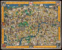
Alternative Title:
Heart of Britain's Empire here is spread out for your view
Publisher:
Westminster Press,
Subject (Geographic):
London (England)--Maps
Found in:
Beinecke Rare Book and Manuscript Library > Wonderground map of the London Town drawn by MacDonald Gill.
Published / Created:
c1914.
Call Number:
32am L84 1914
Container / Volume:
BRBL_00075
Image Count:
1
Resource Type:
Maps, Atlases & Globes
Alternative Title:
Heart of Britain's Empire here is spread out for your view
Publisher:
Westminster Press,
Subject (Geographic):
London (England)--Maps
Found in:
Beinecke Rare Book and Manuscript Library > Wonderground map of the London Town drawn by MacDonald Gill.
Creator:
Published / Created:
between 1880 and 1905?]
Call Number:
2002 537
Image Count:
32
Description:
Caption title. and Imprint from p. 32.
Publisher:
[s.n. ,
Subject (Topic):
Child welfare--Great Britain and Orphans--Great Britain
Found in:
Beinecke Rare Book and Manuscript Library > Worse than orphans : how I stole two girls and fought for a boy / by T.J. Barnardo, F.R.C.S.E.
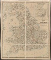
Published / Created:
[1855?]
Call Number:
3191gm 1855
Container / Volume:
BRBL_00041
Image Count:
1
Resource Type:
Maps, Atlases & Globes
Publisher:
James Wyld,
Subject (Geographic):
Great Britain--Maps, Scotland--Maps, and Wales--Maps
Found in:
Beinecke Rare Book and Manuscript Library > Wyld's A map of England, Wales, & Scotland describing all the direct and principal cross roads of Great Britain, with the distances measured between the market towns and from London: Likewise the Great Rivers and Navigable Canals and Railroads.
Creator:
Published / Created:
1873
Call Number:
6555 1873
Container / Volume:
BRBL_00346
Image Count:
1
Resource Type:
Maps, Atlases & Globes
Description:
At head of sheet: "Wylds Military Map". and Insets: Enlarged map [of the route from Coomassie to Anamaboe and Cape Coast Castle; Location maps of Africa and West Africa].
Publisher:
James Wyld,
Subject (Geographic):
Ashanti Region (Ghana)--Maps
Found in:
Beinecke Rare Book and Manuscript Library > Wyld's Map of Ashanti : and neighbouring states with the British Possessions on the Gold Coast / published by James Wyld, Geographer to the Queen, 457 Strand, 11 & 12 Charing Cross & 2 Royal Exchange, London, November 20, 1873.
Creator:
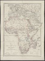
Published / Created:
[1875?]
Call Number:
60 1875
Container / Volume:
BRBL_00327
Image Count:
1
Resource Type:
Maps, Atlases & Globes
Alternative Title:
Africa, Map shewing the various explorations in Africa, and Wyld's map showing the various explorations in Africa
Description:
Relief shown by hachures.
Publisher:
J. Wyld,
Subject (Geographic):
Africa--Discovery and exploration--Maps
Found in:
Beinecke Rare Book and Manuscript Library > Wyld's map shewing the various explorations in Africa / James Wyld.
Creator:
Published / Created:
1861
Call Number:
754hc 1861E
Container / Volume:
BRBL_00420
Image Count:
1
Resource Type:
Maps, Atlases & Globes
Description:
Insets: City of Washington and District of Columbia. Scale ca. 1:190,000. 13 x 14 cm. Country round Washington. Scale ca. 1:1,020,000. 18 x 24 cm.-Pensacola bay and its fortifications. Scale ca. 1:155,000. 12 x 14 cm.-Charleston and the harbour. Scale ca.
Publisher:
James Wyld
Subject (Geographic):
United States--History--Civil War, 1861-1865--Maps
Found in:
Beinecke Rare Book and Manuscript Library > Wyld's military map of the United States, the northern states, and the southern confederate states: with the forts, harbours, arsenals, and military positions.
Creator:
Published / Created:
[1862]
Call Number:
32 L84 1862
Container / Volume:
BRBL_00050
Image Count:
1
Resource Type:
Maps, Atlases & Globes
Alternative Title:
Neuer Plan von London and Nouveau plan de Londres
Description:
Border includes engravings of prominent structures., Imperfect: mutilated with loss of text., and Map in English; some data also in French and German.
Publisher:
Published by James Wyld, Geographer to the Queen and H.R.H. Prince Albert,
Subject (Geographic):
London (England)--Maps
Found in:
Beinecke Rare Book and Manuscript Library > Wyld's new plan of London = Nouveau plan des Londres = Neuer Plan von London.
Branch:v1.61.6 ,Deployed:2024-06-12T09:55:33-04:00