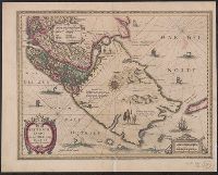
Cross Collection no. 350., From Jodocus Hondius's Appendix Atlantis majoris. [Amsterdam] : Per Iodocum Hondium, 1630., Imperfect: mutilated along fold at bottom, with no loss of text. Mounted on linen., Map of the Straits of Magellan, South America., Relief shown pictorially., and Title in Latin; place names in Dutch.
Publisher:
Judocus Hondius excudit,
Subject (Geographic):
Magellan, Strait of (Chile and Argentina)--Maps--Early works to 1800
Subject (Name):
Gryp, Dirck, engraver and Hondius, Jodocus, 1594 or 1595-1629. Appendix Atlantis majoris
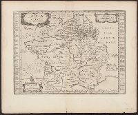
Atlas novus. and Gallia vetus ad Julij Caesaris commentaria
Description:
Latin text on recto; Dutch text on verso., Lower left corner: "Amstelodami apud Ioannem Ianβonium.", Published in Dutch editions of Jansson's Atlas novus (Dutch title: Nieuwen atlas, ofte vveerelts-beschrijvinge), vol. 6, ca. 1662, and Relief shown pictorially.
Publisher:
Jan Jansson,
Subject (Geographic):
France--History--To 987--Maps--Early works to 1800 and Gaul--Maps--Early works to 1800
Broeck, Crispin van den, 1524-ca. 1591 Visscher, Nicolaes, 1618-1679
Published / Created:
[ca. 1660]
Call Number:
1983 Folio 19
Collection Title:
[Atlas factice of 96 maps by Blaeu, Visscher, Jansson, Hondius and others]
Image Count:
2
Alternative Title:
Armenia Maior and Asia et Armenia Minor
Description:
Imperfect: illustrations at top cut-out and replaced with ms. titles "Asia et Armenia minor" (upper left) and "Armenia minor" (in upper right); torn along fold and at left edge, with some loss of text. Sheet measures 32 x 47.8 cm. Reinforced along edges with printed waste. No. 85 of 92 maps bound together. and Numbered 91 on verso.
Publisher:
[Nicolaes Visscher]
Subject (Geographic):
Armenia --Maps --Early works to 1800, Assyria --Maps, Egypt --Maps --Early works to 1800, Middle east --Maps --Early works to 1800, Palestine --Geography --Maps --Early works to 1800, Saudi Arabia --Maps, Syria --Maps, and Turkey --Maps
Gouwen, Gilliam van der Visscher, Nicolaes, 1649-1702, creator
Published / Created:
[1690?]
Call Number:
1973 Folio 10
Image Count:
1
Resource Type:
Maps, Atlases & Globes
Alternative Title:
Landkaart vertonende het Graafschap Holland
Description:
Alternate title in upper margin: Landkaart vertonende het Graafschap Holland, seer dienstig om te reysen na : en van syne naburige provincien, als mede de Hoven van Soestdyk, 't Loo en Cleef / t' Amsteldam door Nicolaus Visscher met privilegie., Bar scales in Milliaria Germanica communia and Milliaria Gallica sive horae itineris., Ferro meridian., Includes col. ill. of figures in title cartouche., No. 44 of 69 maps bound together in composite atlas., Place-names in Dutch., Relief shown pictorially., and Scale [ca. 1:300 000].
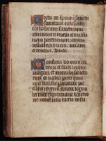
f. 221r-221v: Apostles' Creed and the Confiteor; the latter incomplete, ending with "consensu tactu uisu". The phrase "ego infelix peccatrix" in the Confiteor indicates that the book was written for use by a woman. and Manuscript on parchment (trimmed) of a Book of Hours, with Calendar and prayers in Flemish.
Description:
Binding: Nineteenth century. Brown, originally black, sheepskin; stamped in gold on the spine: "Psaterium." Red edges., Script: Written in liturgical gothic bookhand by one scribe., and Three full-page miniatures of mediocre quality. Each miniature set in a narrow frame of gold, black, pink, and white; full border of blue and gold acanthus leaves, red, pink, and blue flowers and strawberries, and black pen flecks. One 7-line historiated initial on f. 216r (Flemish Prayers): Pieta, pink with white highlights on gold; full border as above; text separated from border by a narrow band attached to initial of gold and pink, edged in black. Illuminated 5-line initials with full borders (eg. ff. 13r, 18r, 28r), pink or blue with white highlights on gold, filled with blue or pink trilobe leaves. 2-line initials, gold on pink and blue with white highlights, one on f. 92r (Advent Office) with a band attached, as above, and small sections of border, as above; one 3-line initial on f. 179r (Obsecro te) in similar manner. 1-line initials, blue with red penwork and gold with black penwork; initials within text washed in yellow. KL monograms as 2-line initials; Latin names of months and important feasts in red. Line fillers: oblique lines with dots attached, stylized plant motifs, dots, etc., in blue or gold. Rubrics in faded red.
Subject (Name):
Catholic Church--Prayers and devotions
Subject (Topic):
Books of hours, Illumination of books and manuscripts, Medieval, Manuscripts, Medieval--Connecticut--New Haven, and Medieval and Renaissance Manuscripts in Beinecke Library
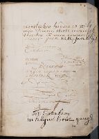
Manuscript on parchment of a Book of Hours with prayers in Dutch. The manuscript is misbound. and Written in liturgical gothic bookhand by a single scribe.
Description:
On fol. 42r: Various manuscript signatures and notes with the name "Anna Bogardus" and "Bedelaer [?]" another hand has added a note with reference to "Haerlem.
Subject (Name):
Catholic Church--Prayers and devotions
Subject (Topic):
Books of hours, Illumination of books and manuscripts, Medieval, Manuscripts, Medieval--Connecticut--New Haven, and Medieval and Renaissance Manuscripts in Beinecke Library
Uytenbogaart, J. W. H. (Johannes Wilhelmus Huybert) Wit, Frederik de., creator
Published / Created:
[1680?]
Call Number:
1973 Folio 10
Image Count:
1
Resource Type:
Maps, Atlases & Globes
Description:
Appears in the Wit's Atlas from 1680., Dedication: Amplissimo Doctissimoque Viro Domino Do. Joanni Uytenbogaert Jcto. nomine Illustrium et praepotent. DD. ordinum Hollandiae et Westvrisiae Aerary Publici Amstelodamensis Tribuno., Includes color illustrated views of Messina, Catania, and Trapano, and ancillary maps of Milazzo and Palermo., No. 21 of 69 maps bound together in composite atlas., Oriented with north toward the upper left., Relief shown pictorially., Scale indeterminable., and Urbibus praecipuis exornatum et novissime editum per F. de Wit.
Publisher:
Gedruckt tot Amsterdam by Frederik de Wit inde Kalverstraet by den Dam inde Witte Paskaert
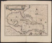
Insulae Americanae in Oceano Septentrionali cum terris adjacentibus and Insvlae Americanae in Oceano Septentrionali cum terris adiacentibus
Description:
Appears in various Dutch eds. of Jansson's Nieuwen atlas., Includes scales in milliaria germanica and mill, and Shows southeast coast of North America from Virginia to north coast of South America to east of Trinidad, west coast of Central America, West Indies.
Publisher:
Apud Ioannem Ianssonium,
Subject (Geographic):
Caribbean Area--Maps--Early works to 1800, Mexico, Gulf of--Maps--Early works to 1800, and West Indies--Maps--Early works to 1800
Subject (Name):
Jansson, Jan, 1588-1664. Atlas novus. Dutch
Subject (Topic):
Coasts--North America--Maps--Early works to 1800 and Coasts--South America--Maps--Early works to 1800
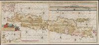
Also shows p, Includes text, col. view of Jakarta, inset of Jakarta, and some cities are marked with gilt., Library copy joined to form 1 sheet., Pars occidentalis --, Prime meridian: Ferro., and Title and notes in Latin. Place-names and scale statements in Dutch.
Publisher:
by Gerard van Keulen aan de Nieuwe brug met previlegie,
Subject (Geographic):
Jakarta (Indonesia)--Maps--Early works to 1800 and Java (Indonesia)--Maps--Early works to 1800