Imperfect: upper left corner cut-out, with some loss of text., Includes text in upper right corner: Population s, and Map of London showing railways, stations, postal boundaries, parks, omnibus and tram routes, steamboat piers and steamboat routes.
Publisher:
Published by Letts, Son & Co., London Bridge, E.C.,
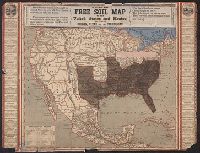
Hand-colored cerographic map with strips of paper pasted on to show relative populations in free and slave states. Shows Gila River Mexican War boundary settlement. Trials to Oregon territory are also shown.
Border of state seals. and Hand-colored cerographic map showing the free soil and slave states along with the territories of the United States. Gila River Mexican War settlement boundary shown. Oregon trial and other routes to the Oregon territory are shown.
"Entered according to act of Congress in the year A.D. 1858 by G.W. Lewis in the clerks office of the district court for the southern district of New York." and Relief shown by hachures.
Publisher:
Lith. & pub. by G.W. Lewis,
Subject (Geographic):
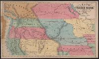
Canada--Maps, Overland Trails--Maps, and West (U.S.)--Maps