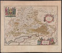
Appears in: Blaeu, Joan. Theatrum orbis terrarum, sive atlas novus, French editions [Amsterdam : Joan Blaeu, between 1643 and 1650]., Latin text on recto and verso., Relief shown pictorially., Sheet measures 47 x 56 cm. Lada-Mocarski collection., and Verso: Title
Publisher:
Joan Blaeu,
Subject (Geographic):
Russia--Maps--Early works to 1800
Subject (Name):
Blaeu, Cornelis and Blaeu, Joan, 1596-1673. Theatrum orbis terrarum
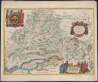
Bottom center: "Apud Johan. et Cornelium Blaeu.", From: Blaeu, Joan. Theatrum orbis terrarum, sive atlas novus, Latin edition [Amsterdam : Joan Blaeu, 1644]., Lati, Relief shown pictorially., and Verso: Title "Moscoviae pars avstralior"; page no. 22; signature V.
Publisher:
Joan Blaeu,
Subject (Geographic):
Russia--Maps--Early works to 1800
Subject (Name):
Blaeu, Cornelis and Blaeu, Joan, 1596-1673. Theatrum orbis terrarum
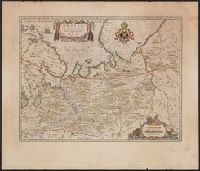
Teutschland mit seinen angrantzenden Konigreichen und Provincien
Description:
"Mit privilegie derer H.H. Staten General des Vereinigten Niederländ"., Bar scales given in "teutsche Meilen" and "französiche Meilen"., Prime meridian: Ferro., Sheet measures 51.8 x 62.0 cm. Ms. no. in upper right corner: 105., and Watermark.
Publisher:
Nicolaus Visscher,
Subject (Geographic):
Europe, Central--Maps--Early works to 1800 and Holy Roman Empire--Maps--Early works to 1800
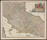
Appears in various editions of Wit's Atlas., Bar scales in "Milliaria Germanica communia 15 in uno gradu," "Milliaria Gallica magna, sive horae itineris,, Relief shown pictorially., and Sheet measures 53.3 x 62.1 cm. Ms. no. in upper right corner: 113.
Publisher:
Frederik de Wit?,
Subject (Geographic):
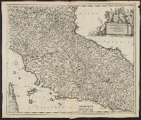
Tuscany (Grand Duchy)--Maps--Early works to 1800
Subject (Name):
Rodriguez, José M.--Bookplate and Wit, Frederik de. Atlas
Appears in various editions of Wit's Atlas., Bar scales in "Milliaria Germanica communia 15 in uno gradu," "Milliaria Gallica magna, sive horae itineris," and "mil, Relief shown pictorially., and Sheet measures 53.3 x 62.1 cm. Ms. no. in upper right corner: 113.
Publisher:
Frederik de Wit?,
Subject (Geographic):
Tuscany (Grand Duchy)--Maps--Early works to 1800
Subject (Name):
Rodriguez, José M.--Bookplate and Wit, Frederik de. Atlas
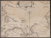
Tabula geographia in qua admirandae navigationis cursus et recursus designatur
Description:
Cross collection no. 52., From: Rerum et urbis Amstelodamensium historia. Amsterodami : Excudit J. Hondius, 1611., In upper right: Fol. 168., and Includes text.
Publisher:
J. Hondius,
Subject (Geographic):
Arctic Regions--Maps--Early works to 1800
Subject (Name):
Hondius, Jodocus, 1563-1612 and Pontanus, Johannes Isacius, 1571-1639. Rerum et urbis Amstelodamensium historia
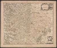
Coat of arms of Bologna., Decorative cartouche., Pg. no. on verso: 35., Relief shown pictorially., Signature on verso: Aaa., and Title on verso: Territorivm Bononiense.
Publisher:
Blaeu,
Subject (Geographic):
Bologna (Italy : Province)--Maps--Early works to 1800