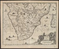
From Ogilby's Africa, being an accurate description of the regions of Egypt, Barbary, Lybia and Billedulgerid. 1670., Has watermarks., Includes ill. and decorative cartouche., and Relief shown pictorially.
Publisher:
Printed by T. Johnson for the author,
Subject (Geographic):
Africa, Sub-Saharan--Maps--Early works to 1800
Subject (Name):
Ogilby, John, 1600-1676. Africa, being an accurate description of the regions of Egypt, Barbary, Lybia and Billedulgerid
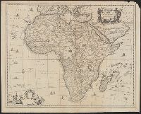
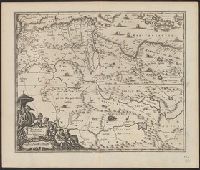
From Ogilby's Africa, being an accurate description of the regions of Egypt, Barbary, Lybia and Billedulgerid. 1670., Has watermarks., Includes ill. and decorative cartouche., and Relief shown pictorially.
Publisher:
Printed by T. Johnson for the author,
Subject (Geographic):
Africa, Central--Maps--Early works to 1800, Africa, Eastern--Maps--Early works to 1800, and Africa, North--Maps--Early works to 1800
Subject (Name):
Ogilby, John, 1600-1676. Africa, being an accurate description of the regions of Egypt, Barbary, Lybia and Billedulgerid
From Ogilby's Africa, being an accurate description of the regions of Egypt, Barbary, Lybia and Billedulgerid. 1670., Includes decorative title and blank dedication cartouches and ill., Relief shown pictorially., and Sheet measures 47 x 59 cm.
Publisher:
Printed by T. Johnson for the author [i.e. J. Ogilby],
Subject (Geographic):
Africa--Maps--Early works to 1800
Subject (Name):
Ogilby, John, 1600-1676. Africa, being an accurate description of the regions of Egypt, Barbary, Lybia and Billedulgerid
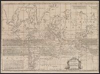
Cross collection no. 43. and Map of the world showing wind patterns and incomplete outline of Australia and New Zealand. Also shows time differences and some relief in hill shading.
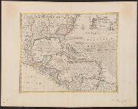
"No. 57.", From Bowen's A complete system of geography ... London : Printed for W. Innys, R. Ware, Aaron Ward ..., 1747., Includes bar scale in English miles., Relief shown pictorially., Sheet measures 44.9 x 58 cm. Cross Collection no. 243., and Shows sailing tracks, currents, shoals, etc.; includes historical notes and ornamental cartouche.
Publisher:
Printed for William Innys, Richard Ware, Aaron Ward ...,
Subject (Geographic):
Caribbean Area--Maps--Early works to 1800 and North America--Maps--Early works to 1800
Subject (Name):
Bowen, Emanuel, d. 1767. Complete system of geography
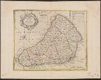
"No. 69" in lower left corner., Bar scale given in "English miles 60 to a degree.", Cross Collection no. 308., From Bowen's A complete system of geography. London : Printed for W. Innys, R. Ware ..., 1747., Hand col., Imperfect: wormholes in margins, with no loss of text., Includes table of parish acreages and ornamental cartouche., and Relief shown pictorially.
Publisher:
Printed for W. Innys, R. Ware ...,
Subject (Geographic):
Barbados--Maps--Early works to 1800
Subject (Name):
Bowen, Emanuel, d. 1767. A complete system of geography
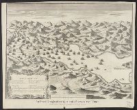
Bounding coordinates not present and are approximated., Explanation in cartouche in lower left corner., Oriented with north to the left., Pictorial relief., Shows ships in battle, fortifications, city, fields, mountains., and Watermark in each half.
Bounding coordinates not present and are approximated., Explanation in cartouche in lower left corner., Oriented with north to the left., Pictorial relief., Shows ships in battle, fortifications, city, fields, mountains., and Stamp: Karpinski-Von Wieser Map Collec
From Ogilby's Africa, being an accurate description of the regions of Egypt, Barbary, Lybia and Billedulgerid. 1670., Has watermarks., Includes ill. and decorative cartouche., and Relief shown pictorially.
Publisher:
Printed by T. Johnson for the author,
Subject (Geographic):
Africa, North--Maps--Early works to 1800
Subject (Name):
Ogilby, John, 1600-1676. Africa, being an accurate description of the regions of Egypt, Barbary, Lybia and Billedulgerid