Skip to search
Skip to main content
Skip to first result
Search
You Searched For
Genre
Maps
Publication Place
[Washington] :
New Search
Search Results
Creator:
Published / Created:
1943
Call Number:
71gm 1943
Container / Volume:
BRBL_00371
Image Count:
1
Resource Type:
Maps, Atlases & Globes
Description:
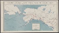
"26 March 1943.", "Map No.2014.", and Shows air routes, highways, projected highways, railroads, trails, and oil pipe lines under construction.
Publisher:
U.S. Office of Strategic Services,
Subject (Name):
United States. Board of Economic Warfare
Subject (Topic):
Railroads--Canada--Maps, Railroads--Northern Hemisphere--Maps, Transportation--Alaska--Maps, Transportation--Canada--Maps, and Transportation--Russia (Federation)--Siberia, Eastern--Maps
Found in:
Beinecke Rare Book and Manuscript Library > Transport facilities linking Canada, Alaska, and Eastern Siberia : Board of Economic Warfare, Project No.EP-17, O.E.W.A.
Creator:
Published / Created:
1875
Call Number:
764 P37 1874
Container / Volume:
BRBL_00459
Image Count:
1
Resource Type:
Maps, Atlases & Globes
Description:
"C. S. Pierce, Assistant in charge of party, topographical survey by W.E. McClintock, Aid.", "Issued September 1875. C.P. Patterson, Superintendent. Verification by J.E. Hilgard, Assistant in charge of office.", "No. 3030.", and Relief shown by contours.
Publisher:
U.S. Coast Survey,
Subject (Geographic):
Hoosac Range (Mass.)--Maps and Hoosac Tunnel (Mass.)--Maps
Subject (Name):
U.S. Coast and Geodetic Survey
Found in:
Beinecke Rare Book and Manuscript Library > Two miles around the pendulum station on Hoosac Mountain near central shaft of tunnel, Massachusetts, 1874.
Published / Created:
1909
Call Number:
75ak 1909
Container / Volume:
BRBL_00407A
Image Count:
1
Resource Type:
Maps, Atlases & Globes
Description:
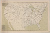
"Edition of Jan. 1907, reprinted Apr. 1909."
Publisher:
U.S.G. Survey,
Subject (Geographic):
United States--Maps
Found in:
Beinecke Rare Book and Manuscript Library > United States Base Map / engraved by U.S.G.S.
Published / Created:
[1899?].
Call Number:
75CBF 1899B
Container / Volume:
BRBL_00408
Image Count:
1
Resource Type:
Maps, Atlases & Globes
Publisher:
U.S.G.S.,
Subject (Geographic):
United States--Maps
Found in:
Beinecke Rare Book and Manuscript Library > United States contour map / U.S. Geological Survey, J.W. Powell, Director ; compiled by Henry Gannett.
Creator:
Published / Created:
1910
Call Number:
75cbf 1910
Container / Volume:
BRBL_00408
Image Count:
1
Resource Type:
Maps, Atlases & Globes
Description:
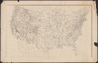
Relief shown by contours and gradient tints.
Publisher:
USGS,
Subject (Geographic):
United States--Maps
Subject (Name):
Gannett, Henry, 1846-1914
Found in:
Beinecke Rare Book and Manuscript Library > United States relief map / compiled by Henry Gannett.
Published / Created:
[1915].
Call Number:
38 C395 1915
Container / Volume:
BRBL_00156
Image Count:
1
Resource Type:
Maps, Atlases & Globes
Publisher:
Topographical Division, Intelligence Section, G.S.N.E.F.,
Subject (Geographic):
Chaumont (Haute-Marne, France)--Maps
Found in:
Beinecke Rare Book and Manuscript Library > Ville de Chaumont.
Creator:
Published / Created:
1881
Call Number:
847cea W279 1880
Container / Volume:
BRBL_00628
Image Count:
1
Resource Type:
Maps, Atlases & Globes
Alternative Title:
[Chart] : no. 654. and U.S. Coast and Geodetic Survey. Chart ; no. 654.
Description:
"Aids to navigation corrected to 1880.", "Electrotype copy no. 1 by G. Mathiot U.S.C.S.", Includes text., Relief shown by hachures and spot heights; depths shown by soundings., and Shows Strait of Juan de Fuca region.
Publisher:
Coast and Geodetic Survey,
Subject (Geographic):
Juan de Fuca, Strait of, Region (B.C. and Wash.)--Maps
Subject (Topic):
Nautical charts--Juan de Fuca, Strait of, Region (B.C. and Wash.)
Found in:
Beinecke Rare Book and Manuscript Library > Washington Sound and approaches, Washington Territory : 1866.
Creator:
Published / Created:
1879
Call Number:
847 1879
Container / Volume:
BRBL_00625
Image Count:
1
Resource Type:
Maps, Atlases & Globes
Description:
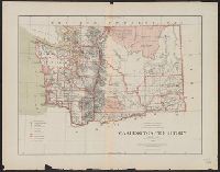
"J.A. Williamson, Commissioner" General Land Office., "Longitude west from Greenwich and Washington.", and Relief shown by hachures.
Publisher:
The Office,
Subject (Geographic):
Washington (State)--Maps
Subject (Name):
Bien, Julius, 1826-1909 and Roeser, C. (Charles)
Found in:
Beinecke Rare Book and Manuscript Library > Washington Territory / compiled from the official records of the General Land Office and other sources by C. Roeser, Principal Draughtsman, General Land Office.
Creator:
Published / Created:
1934
Call Number:
847fb 1930
Container / Volume:
BRBL_00628
Image Count:
1
Resource Type:
Maps, Atlases & Globes
Publisher:
Government Printing Office,
Subject (Geographic):
Washington (State)--Administrative and political divisions--Maps
Found in:
Beinecke Rare Book and Manuscript Library > Washington, minor civil divisions / Bureau of the Census, 1930.
Creator:
Published / Created:
1898
Call Number:
848 Y91 1898
Container / Volume:
BRBL_00634
Image Count:
1
Resource Type:
Maps, Atlases & Globes
Alternative Title:
(Yukon River) U.S.C. & G.S. 3098, [Chart] ; no. 3098, and U.S. Coast and Geodetic Survey. Chart ; no. 3098.
Description:
Included notes and tables., Ms. signature under title., and Relief shown by hachures and spot heights.
Publisher:
U.S. Coast and Geodetic Survey,
Subject (Geographic):
Yukon River Valley (Yukon and Alaska)--Maps
Found in:
Beinecke Rare Book and Manuscript Library > Yukon River, Alaska.
Branch:v1.61.6 ,Deployed:2024-06-12T09:55:33-04:00