New York 1730 and New York, the English Colonial city
Description:
"The principal points of interest for this period are in red.", Includes historical notes., Relief shown by hachures., Shows the footprints of some historic buildings and of Fort George and names them; roads and wharves are also named., and This is one map from the set titled: Early New York.
Publisher:
Townsend MacCoun,
Subject (Geographic):
Manhattan (New York, N.Y.)--History--Colonial period, ca. 1600-1775--Maps, New York (N.Y.)--History--Colonial period, ca. 1600-1775--Maps, and New York (N.Y.)--Maps
The description of this slide reflects the way that Erdoes organized 35mm slides. Erdoes arranged his slides in labeled containers that were sub-divided into labeled sections. The title for this image has been transcribed from its sub-section label; images of other slides from the same sub-section share the container title. The date listed here reflects a span of known dates associated the sub-section. In some cases, titles have been expanded to note particular individuals who appear frequently and who were identified by Erdoes in captions. Individual slide captions have not been transcribed or captured during digitization.
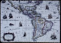
Subject (Geographic):
North America--Maps--Early works to 1800 and South America--Maps--Early works to 1800