Skip to search
Skip to main content
Skip to first result
Search
You Searched For
Format
cartographic
New Search
Search Results
Published / Created:
1813
Call Number:
769cea 1813
Container / Volume:
BRBL_00476
Image Count:
2
Resource Type:
Maps, Atlases & Globes
Description:
Negative photostat. and Soundings in feet, shoreline hachured; beaches stippled; rocks shown by small circles lighthouses shown in outline, tinted red by hand. New haven entrance shown just above compass rose at center of chart. Publisher's name and place of
Publisher:
Edmund M. Blunt],
Subject (Geographic):
Long Island Sound (N.Y. and Conn.)--Maps
Found in:
Beinecke Rare Book and Manuscript Library > Blunt's new and correct chart of Long Island Sound, from Montauk Point to Frog's Point, including Fisher's Island Sound, and Watch Hill Reef. Surveyed in 1805 by John Cahoone, Newport, and Fosdick, New London.
Creator:
Published / Created:
1943
Call Number:
213 B63 1943
Container / Volume:
BRBL_00015
Image Count:
1
Resource Type:
Maps, Atlases & Globes
Alternative Title:
G.S.,G.S. ; no. 4111 and GSGS (Series) ; 4111.
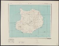
Description:
Elevations shown by form lines and spot heights., In upper margin: Cape Verde ids ..., and Military grid.
Publisher:
Army Map Service, U.S. Army,
Subject (Geographic):
Boa Vista, Cape Verde Islands--Maps, Topographic and Cabo Verde--Maps
Found in:
Beinecke Rare Book and Manuscript Library > Boa Vista / drawn at War Office, 1940, from a Portuguese map of 1924.
Published / Created:
Undated
Call Number:
1983 Folio 19
Collection Title:
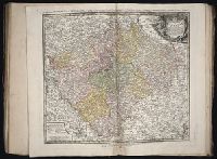
[Atlas factice of 96 maps by Blaeu, Visscher, Jansson, Hondius and others]
Image Count:
2
Publisher:
Apud Ioannem Ianssonium
Subject (Geographic):
Austria --Maps --Early works to 1800, Czechoslovakia --Maps, Germany --Maps --Early works to 1800, and Poland --Maps --Early works to 1800
Subject (Topic):
Atlases --Early works to 1800
Collection Created:
[1556-1680]
Found in:
Beinecke Rare Book and Manuscript Library > Bohemia
Creator:
Published / Created:
1907
Call Number:
98 1907
Container / Volume:
BRBL_00679
Image Count:
1
Resource Type:
Maps, Atlases & Globes
Publisher:
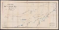
Adolfo Ballivián,
Subject (Geographic):
Bolivia--Boundaries--Brazil--Maps and Brazil--Boundaries--Bolivia--Maps
Subject (Name):
Ballivián, Adolfo, 1831-1873 and Fawcett, Percy Harrison, 1867-1925?
Found in:
Beinecke Rare Book and Manuscript Library > Bolivia, la frontera del Norte / P.H. Fawcett, F.R.G.S. Mayor Artill. Real de Gran Bretaña, Ingeniero de la Comisión de Límites ; publicado por Adolfo Ballivian, Jefe de la Comisión Boliviana ; Imprenta y Litografía Boliviana.
Creator:
Published / Created:
[1725?]
Call Number:
BrSides 2019 67
Image Count:
1
Resource Type:
Maps, Atlases & Globes
Alternative Title:
Bononien
Description:
"Cum privil. sacrae caeser. maiest." and Accompanied by sheet with provenance note, "Gift to Jack in 1954 from Katharine Kosmak ... that once belonged to her father ... Dr. George Kosmak."
Publisher:
[Johann Christian Leopold],
Subject (Geographic):
Bologna (Italy)--Pictorial works--Early works to 1800.
Subject (Name):
Kosmak, George William,--1873---Ownership. and Kosmak, Katharine--Ownership.
Found in:
Beinecke Rare Book and Manuscript Library > Bologna = Bononien / Iohann Christian Leopold excudit, Aug. Vind.
Branch:v1.61.6 ,Deployed:2024-06-12T09:55:36-04:00