Skip to search
Skip to main content
Skip to first result
Search
You Searched For
Format
cartographic
New Search
Search Results
Published / Created:
1889?].
Call Number:
764 B65 1889A
Container / Volume:
BRBL_00456
Image Count:
1
Resource Type:
Maps, Atlases & Globes
Description:
Cf. Phillips' "List of Maps of America" p.161? and From Brown's "The Continental Atlas" (1889?), pp. 50-51.
Publisher:
Milton R. Brown,
Subject (Geographic):
Massachusetts--Boston--Maps
Found in:
Beinecke Rare Book and Manuscript Library > Boston and adjacent cities.
Creator:
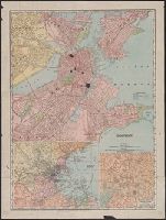
Published / Created:
c1903.
Call Number:
764 B65 1903
Container / Volume:
BRBL_00456
Image Count:
1
Resource Type:
Maps, Atlases & Globes
Description:
Includes insets: "Business portion of Boston" and "Environs of Boston." and Map originally part of an atlas.
Publisher:
Rand-McNally,
Subject (Geographic):
Boston (Mass.)--Maps and Boston Metropolitan Area (Mass.)--Maps
Subject (Topic):
Central business districts--Massachusetts--Boston--Maps
Found in:
Beinecke Rare Book and Manuscript Library > Boston.
Creator:
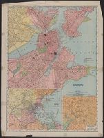
Published / Created:
1907
Call Number:
764 B65 1907A
Container / Volume:
BRBL_00456
Image Count:
2
Resource Type:
Maps, Atlases & Globes
Alternative Title:
Rand, McNally & Co.'s new business atlas map of Boston
Description:
2 insets: Environs of Boston, Business portion of Boston. and Verso: Trolley map of Massachusetts, tourist information, text and advertising.
Publisher:
Rand McNally & Co.,
Subject (Geographic):
Boston (Mass.)--Maps and Massachusetts--Maps
Found in:
Beinecke Rare Book and Manuscript Library > Boston.
Creator:
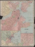
Published / Created:
1909
Call Number:
764 B65 1909M
Container / Volume:
BRBL_00456A
Image Count:
2
Resource Type:
Maps, Atlases & Globes
Description:
Includes insets: Environs of Boston and Business portion of Boston., On verso: Trolley maps of Massachusetts, 21 x 39 cm., and Part of Rand, McNally & Co.'s new business atlas map of Boston.
Publisher:
Rand-McNally,
Subject (Geographic):
Boston (Mass.)--Maps and Massachusetts--Maps
Subject (Topic):
Central business districts--Massachusetts--Boston--Maps
Found in:
Beinecke Rare Book and Manuscript Library > Boston.
Creator:
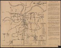
Published / Created:
1921
Call Number:
816 K134 1921
Container / Volume:
BRBL_00562
Image Count:
2
Resource Type:
Maps, Atlases & Globes
Alternative Title:
Official routes of twenty-five trail highways, named and numbered, radiating from greater Kansas City.
Description:
Includes indexes, text, and ancillary map of Missouri. and June 1921 edition of 1919 map.
Publisher:
Good Roads Association of Kansas City,
Subject (Geographic):
Kansas City Region (Mo.)--Maps
Subject (Topic):
Roads--Missouri--Kansas City Region--Maps and Streets--Missouri--Kansas City--Maps
Found in:
Beinecke Rare Book and Manuscript Library > Boulevards and streets, named and numbered, connecting with all highways radiating from greater Kansas City ; The official routes of twenty-five trail highways, named and numbered, radiating from greater Kansas City / by Good Roads Association of Greater
Creator:
Published / Created:
1943
Call Number:
38 B66 1943
Container / Volume:
BRBL_00156
Image Count:
1
Resource Type:
Maps, Atlases & Globes
Alternative Title:
Its A.M.S. ; M961 and Series (Standard map series designation system) ; M961.
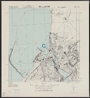
Description:
"Copied from I.S.I.S. report, 1:6,632, Boulogne, CB 1804 no. 9, 1939.", At head of title: France., Military grid., and Some buildings are named.
Publisher:
Army Map Service,
Subject (Geographic):
Boulogne-sur-Mer (France)--Maps
Found in:
Beinecke Rare Book and Manuscript Library > Boulogne [cartographic material] : city plan / prepared under the direction of the Chief of Engineers, U.S. Army.
Creator:
Published / Created:
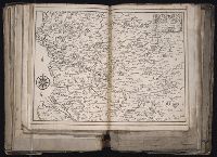
1645
Call Number:
1983 Folio 19
Collection Title:
[Atlas factice of 96 maps by Blaeu, Visscher, Jansson, Hondius and others]
Image Count:
1
Description:
Numbered 58 on verso. and Reinforced along lower edges with manuscript waste. Sheet measures 39.5 x 51.7 cm. No. 54 of 92 maps bound together.
Publisher:
N. Berey
Subject (Geographic):
Boulonnais (France) --Maps --Early works to 1800 and Pas-de-Calais (France) --Maps --Early works to 1800
Found in:
Beinecke Rare Book and Manuscript Library > Boulonnois, Pontieu, Artois, Comte de S. Paul et Pays de la Locoue
Creator:
Call Number:
1977 Folio 114
Collection Title:
L’atlas curieux ou Le monde represente dans des cartes generales et particulieres du ciel et de la
Image Count:
1
Resource Type:
Maps, Atlases & Globes
Description:
Verso blank.
Subject (Geographic):
Fontainebleau (France)
Subject (Topic):
Atlases, French
Collection Created:
A Paris, Chez l’auteur dans l’Isle du Palais sur le quay de l’Orloge a la Sphere Royale, 1700[-03]
Found in:
Beinecke Rare Book and Manuscript Library > Bourg, chateau, et iardins de Fontaine-bleau
Branch:v1.61.6 ,Deployed:2024-06-12T09:55:36-04:00