Skip to search
Skip to main content
Skip to first result
Search
You Searched For
Extent of Digitization
Partially digitized
Resource Type
Maps, Atlases & Globes
New Search
Search Results
Creator:
Call Number:
Ee +633gb
Collection Title:
The voyages and travells of the ambassadors sent by Frederick, duke of Holstein, to the great Duke
Image Count:
1
Resource Type:
Maps, Atlases & Globes
Description:
Between pp. 112-113.
Subject (Geographic):
Asia--Description and travel., East Indies--Description and travel, and Iran--Description and travel.
Subject (Topic):
Voyages and travels
Collection Created:
London : Printed for J. Starkey and T. Basset, 1669
Found in:
Beinecke Rare Book and Manuscript Library > The course of the great River Wolga
Creator:
Published / Created:
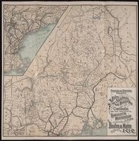
1897 May 3
Call Number:
2002 550
Image Count:
1
Resource Type:
Maps, Atlases & Globes
Publisher:
R. A. Supply Co
Subject (Geographic):
Canada --Description and travel, Maine --Description and travel, and New Hampshire --Description and travel
Found in:
Beinecke Rare Book and Manuscript Library > The direct route to the fishing and hunting resorts of New Hampshire, Maine, and Canada : Lake Winnipesaukee, Rangeley Lakes, Lake St. John, Lake Megantic ...
Creator:
Call Number:
1977 Folio 96
Collection Title:
The West-India atlas: or, A compendious description of the West-Indies: illustrated with forty
Image Count:
1
Resource Type:
Maps, Atlases & Globes
Alternative Title:
The harbours of Kingston and Port Royal and The windward passage, with the several passages, from the...east end of Cuba, and the north part of St. Domingo.
Description:
With two inset maps.
Subject (Geographic):
Cuba. and Santo Domingo (Dominican Republic)
Subject (Topic):
Nautical charts
Collection Created:
London, Printed for Robert Sayer and John Bennett, Fleet-Street, 1775
Found in:
Beinecke Rare Book and Manuscript Library > The harbour of Bluefields.
Creator:
Published / Created:
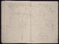
1720
Call Number:
1973 Folio 114
Collection Title:
The English pilot: describing the West-India navigation, from Hudson's-Bay to the river Amazones
Image Count:
1
Resource Type:
Maps, Atlases & Globes
Subject (Geographic):
Atlantic Ocean --Maps --Early works to 1800, Casco Bay (Me.) --Maps --Early works to 1800, Maine --Maps --Early works to 1800, and New England --Maps --Early works to 1800
Subject (Topic):
Navigation --Early works to 1800, Pilot guides --Atlantic Coast (U.S.) --Early works to 1800, and Pilot guides --Caribbean Area --Early works to 1800
Collection Created:
London : Printed for W. and J. Mount, T. Page and son, on Tower-Hill, MDCCLIX [1759]
Found in:
Beinecke Rare Book and Manuscript Library > The harbour of Casco Bay and islands adjacent
Call Number:
WeInd Ehc 762J
Collection Title:
A description of the Spanish islands and settlements on the coast of the West Indies / compiled
Image Count:
1
Resource Type:
Maps, Atlases & Globes
Description:
Between pp. 92-93
Subject (Geographic):
Hispaniola. and West Indies --Description and travel
Collection Created:
London : For T. Jefferys, 1762
Found in:
Beinecke Rare Book and Manuscript Library > The island of Hispaniola called by the French St. Domingo. Subject to France and Spain
Creator:
Call Number:
C6 033c
Collection Title:
The natural and civil history of the French dominions in North and South America : with an
Image Count:
1
Resource Type:
Maps, Atlases & Globes
Description:
Plate between p. 2-3.
Subject (Geographic):
Atlantic Ocean--Charts, maps, etc., Atlantic Ocean--Maps--Early works to 1800, and Santo Domingo (Dominican Republic)
Collection Created:
London, Printed for T. Jeffreys, 1761
Found in:
Beinecke Rare Book and Manuscript Library > The island of Hispaniola called by the French St. Domingo. Subject to France and Spain. from the best authorities by Thomas Jeffreys, geographer to his Royal Highness the Prince of Wales
Call Number:
1973 Folio 114
Collection Title:
The English pilot: describing the West-India navigation, from Hudson's-Bay to the river Amazones
Image Count:
1
Resource Type:
Maps, Atlases & Globes
Subject (Geographic):
Atlantic Ocean --Maps --Early works to 1800, Jamaica --Maps --Early works to 1800, and West Indies --Maps --Early works to 1800
Subject (Topic):
Navigation --Early works to 1800, Pilot guides --Atlantic Coast (U.S.) --Early works to 1800, and Pilot guides --Caribbean Area --Early works to 1800
Collection Created:
London : Printed for W. and J. Mount, T. Page and son, on Tower-Hill, MDCCLIX [1759]
Found in:
Beinecke Rare Book and Manuscript Library > The island of Jamaica
Creator:
Call Number:
Zc35 +961rp
Collection Title:
To Celebrate 100 years of Dakota Territory : the Dakota Territorial Centennial Commission presents
Image Count:
1
Resource Type:
Maps, Atlases & Globes
Abstract:
One larger map and four inset maps.
Alternative Title:
Dakota Territory.
Subject (Geographic):
Dakota Territory --History
Collection Created:
Mitchell, S.D. : The Commission, c1961
Found in:
Beinecke Rare Book and Manuscript Library > The lands within the bold boundary were included, at some time or other, but never all at the same time, in Dakota Territory
Creator:
Published / Created:
ann. 1605.
Call Number:
1976 Folio 46
Image Count:
1
Resource Type:
Maps, Atlases & Globes
Alternative Title:
Mariners mirrour.
Description:
Map oriented with North at bottom left.
Publisher:
Jodocus Hondius excudit,
Subject (Geographic):
Great Britain --Maps --Early works to 1800, Netherlands --Maps --Early works to 1800, and North Sea --Maps --Early works to 1800
Found in:
Beinecke Rare Book and Manuscript Library > The mariners mirrovr wherin may playnly be seen the courses, heights, distances, depths, sounding, flouds and ebs, risings of lands, rocks ... of the harbouroughs, havens and ports of the greatest part of Europe: ... together w.th the rules and instrumeíÄ
Published / Created:
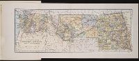
c1889
Call Number:
Zc10 889iv
Collection Title:
The new states; a sketch of the history and development of the states of North Dakota, South Dakota
Image Count:
1
Resource Type:
Maps, Atlases & Globes
Description:
Between pp. 72-73 and Stamped on verso: Swinton's Geography.
Subject (Geographic):
Montana --History., North Dakota --History., South Dakota --History., and Washington (State) --History
Collection Created:
New York ; Chicago : Ivison, Blakeman & Company, c1889
Found in:
Beinecke Rare Book and Manuscript Library > The new states North Dakota, South Dakota, Montana and Washington
Branch:v1.61.8 ,Deployed:2024-06-20T11:14:46-04:00