Search
You Searched For
Search Results
- Call Number:
- 1973 Folio 114
- Collection Title:
- The English pilot: describing the West-India navigation, from Hudson's-Bay to the river Amazones
- Image Count:
- 1
- Resource Type:
- Maps, Atlases & Globes
- Subject (Geographic):
- Atlantic Ocean --Maps --Early works to 1800, Jamaica --Maps --Early works to 1800, and West Indies --Maps --Early works to 1800
- Subject (Topic):
- Navigation --Early works to 1800, Pilot guides --Atlantic Coast (U.S.) --Early works to 1800, and Pilot guides --Caribbean Area --Early works to 1800
- Collection Created:
- London : Printed for W. and J. Mount, T. Page and son, on Tower-Hill, MDCCLIX [1759]
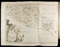
- Found in:
- Beinecke Rare Book and Manuscript Library > The island of Jamaica
- Published / Created:
- [ca. 1625]
- Call Number:
- Pequot +P978
- Collection Title:
- Purchas his pilgrimes : In fiue bookes. The first, contayning the voyages and peregrinations made
- Image Count:
- 1
- Description:
- Bound in following p. 400.
- Subject (Geographic):
- America--Discovery and exploration--Early works to 1800 and China--Maps--Early works to 1800
- Subject (Topic):
- Geography--Early works to 1800, Religions--Early works to 1800, and Voyages and travels--Early works to 1800
- Collection Created:
- London :
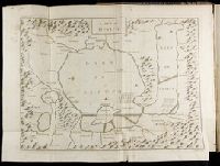
- Found in:
- Beinecke Rare Book and Manuscript Library > The map of China
- Creator:
- Waghenaer, Lucas Janszoon, 1534 or 5-1606
- Published / Created:
- ann. 1605.
- Call Number:
- 1976 Folio 46
- Image Count:
- 1
- Resource Type:
- Maps, Atlases & Globes
- Alternative Title:
- Mariners mirrour.
- Description:
- Map oriented with North at bottom left.
- Publisher:
- Jodocus Hondius excudit,
- Subject (Geographic):
- Great Britain --Maps --Early works to 1800, Netherlands --Maps --Early works to 1800, and North Sea --Maps --Early works to 1800
- Found in:
- Beinecke Rare Book and Manuscript Library > The mariners mirrovr wherin may playnly be seen the courses, heights, distances, depths, sounding, flouds and ebs, risings of lands, rocks ... of the harbouroughs, havens and ports of the greatest part of Europe: ... together w.th the rules and instrumeíÄ
- Creator:
- Elstracke, Renold, fl. 1590-1630
- Published / Created:
- [ca. 1625]
- Call Number:
- Pequot +P978
- Collection Title:
- Purchas his pilgrimes : In fiue bookes. The first, contayning the voyages and peregrinations made
- Image Count:
- 1
- Description:
- Bound in following p. 852.
- Subject (Geographic):
- America--Discovery and exploration--Early works to 1800
- Subject (Topic):
- Geography--Early works to 1800, Religions--Early works to 1800, and Voyages and travels--Early works to 1800
- Collection Created:
- London :
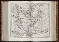
- Found in:
- Beinecke Rare Book and Manuscript Library > The north part of America
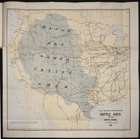
- Published / Created:
- 1884
- Call Number:
- Zc10 885up
- Collection Title:
- Range and ranch cattle
- Image Count:
- 1
- Resource Type:
- Maps, Atlases & Globes
- Description:
- Verso blank.
- Subject (Geographic):
- Arizona, Colorado, Dakota Territory, Idaho, Kansas, Montana, Nebraska, Nevada, New Mexico, Oregon, Texas, Utah, Washington (State), and Wyoming
- Subject (Name):
- Nimmo, Joseph, 1837-1909
- Subject (Topic):
- Cattle --West (U.S.) and Ranches --West (U.S.)
- Collection Created:
- [Washington : Govt. Print. Off., 1885]
- Found in:
- Beinecke Rare Book and Manuscript Library > The range and ranch cattle area of the United States
- Creator:
- Bry, Theodor de, 1528-1598
- Call Number:
- 1976 Folio 110
- Collection Title:
- The mariners mirrovr wherin may playnly be seen the courses, heights, distances, depths, sounding
- Image Count:
- 1
- Resource Type:
- Maps, Atlases & Globes
- Subject (Geographic):
- Dover (England), England, English Channel, and Isle of Wight (England)
- Collection Created:
- [London, J. Charlewood? 1588]
- Found in:
- Beinecke Rare Book and Manuscript Library > The sea coastes of England betweene the Ile of Wight & Douer, with the principal hauens thereof according to their situation and appearing
- Creator:
- Bry, Theodor de, 1528-1598
- Call Number:
- 1976 Folio 110
- Collection Title:
- The mariners mirrovr wherin may playnly be seen the courses, heights, distances, depths, sounding
- Image Count:
- 1
- Resource Type:
- Maps, Atlases & Globes
- Subject (Geographic):
- Bristol Channel, England, and English Channel
- Collection Created:
- [London, J. Charlewood? 1588]
- Found in:
- Beinecke Rare Book and Manuscript Library > The sea coastes of England, from the Sorlinges by the landes end to Plymouth with the hauens and harbrowghes