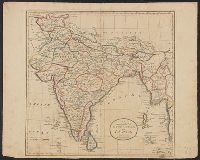
Appears in the Carey's General atlas, improved and enlarged. 1817., Hand col. Mounted on linen. Sheet measures 43 x 53 cm., In top right margin: 53., Name burnished out below title, probably J.T. Scott, sculp., and Relief shown pictorially.
Publisher:
M. Carey & Son,
Subject (Geographic):
India--Maps and South Asia--Maps
Subject (Name):
Carey, Mathew, 1760-1839. Carey's general atlas, improved and enlarged and M. Carey & Sons
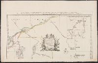
Appears in Thomas Jefferys' A general topography of North America. 1768. no. 22, plates 30-31. and Includes inscription to "Charles Townshend, His Majesty's Secretary at War," text, and inset "A general map of the River St. Lawrence above Montreal to Lake Ont
1 of 2 copies of 1st state (see also 762 1761). For 2nd state see 762 1784B., 1st state (McCorkle 322, Wheat and Brun 39)., Appears in Jefferys's General Topography of North America (London 1768)., and In cartouche: "Dedicated to the Right Honourable Charles Tow
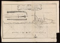
Coordinates not present on map and are approximated., From A new general collection of voyages and travels (London, 1745-47)., Includes illustrations of "weapons used by the Hakbous blacks.", Lower left: "No. 87.", Lower right: "Plate X, Vol. III, p. 105.", and Stamps: Glasgow Public Libraries.
Publisher:
[publisher not identified],
Subject (Geographic):
Cross River State (Nigeria)--Maps--Early works to 1800.
Subject (Name):
Child, G., engraver. and Glasgow (Scotland). Public Libraries Stamp.
Subject (Topic):
Coasts--Nigeria--Calabar Province--Maps--Early works to 1800.
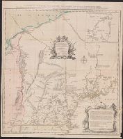
Particular map of Baffin and Hudson's Bay and Passage by land to California discover'd by Father Eusebius Francis Kino ...
Description:
"Longit. w. from Ferro.", Hand colored., Includes historical notes, notes on territorial claims, and insets of "A particular map of Baffin and Hudson's Bay" and "The passage by land to California.", and Relief shown pictorially.
Publisher:
Printed for Robert Sayer, no 53 Fleet Street ...,
Subject (Geographic):
North America--Maps--Early works to 1800
Subject (Name):
Gibson, J. (John), active 1750-1792 and Sayer, Robert, 1725-1794
Bowen, Emanuel, d. 1767 Gibson, J. (John) Overton, Henry, fl. 1706-1764 Sayer, Robert, 1725-1794
Published / Created:
[between 1755 and 1775?]
Call Number:
2003 Folio 85
Image Count:
1
Description:
BEIN 2003 Folio 85: No. 4 of 45 maps bound together with binder's spine title: Atlas of America; ms. table of contents. Bookplate of Paul Mellon., by Eman. Bowen, geogr. to His Majesty, and John Gibson, engraver., Hand-colored., Includes text and insets of A particular map of Baffin and Hudson's Bay and The passage by land to California, discovered by Father Eusebius Francis Kino ...., Relief shown pictorially., Scale [ca. 1:5,500,000]., and Shows boundaries, cities and towns, roads, forts, missions, some industries, trails, trade routes, portages, and vegetation. Also shows Indian villages and tribal territories, routes of navigation in the Gulf of Mexico, and navigational hazards along the coast.
Publisher:
Printed for Robt. Sayer opposite Fetter Lane Fleet Street