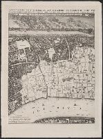
Carte topographique des villes de Londres, Westminster, et bourg de Southwark et de leurs environs., Exact survey of the cities of London and Westminster, the borough of Southwark and the country near ten miles round, and Urbium maxime insignium Londini et Westmonasterii nec non municipii Sudovercencis, regionumque ad decem quasi milliaria circumjacentium.
Description:
"Publish'd 29th of April ... ", No. 3 of 7 maps bound together in a vol. with hand-lettered dust jacket with ms. title, "Rocque's map of London, 1746,"and autograph of Ralph Hodgson., and Relief shown by shading.
Publisher:
John Rocque,
Subject (Geographic):
London (England)--Maps--Early works to 1800.
Subject (Name):
Hodgson, Ralph,--1871-1962--Autograph., Parr, Richard, fl. 1723-1751., and Pratt, W.
Exact surveigh of the streets, lanes, and chvrches contained within the rvines of the city of London.
Description:
"Ionas Moore & Ralph Graterix, surveyors.", "The right honourable S. William Turner, the Lord Major, ao. 1669.", Alternate title: Plan of London after the fire., Bird's-eye-view., and Includes "The prospect of this citty, as it appeared from the opposite Southwar
Publisher:
London Topographical Society, and Nathanaell Brooke, stationer
Subject (Geographic):
London (England)--Aerial views--Early works to 1800--Facsimiles
Subject (Name):
Hollar, Wenceslaus, 1607-1677 and London Topographical Society