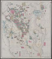
New guide map of the city of Seattle and environs, Washington
Description:
"Entered according to act of Congress in the year 1890 by O.P. Anderson & Co., in the office of the Librarian of Congress at Washington, D.C.", Cadastral map showing some landowners., and Includes inset of Seattle region.
Publisher:
O.P. Anderson & Co.,
Subject (Geographic):
Seattle (Wash.)--Maps
Subject (Name):
L.H. Everts & Co
Subject (Topic):
Landowners--Washington (State)--Seattle--Maps and Real property--Washington (State)--Seattle--Maps
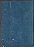
Insets: Sketch map of Cook Inlet -- Sketch map of Munook Creek -- Sketch map of Birch Creek -- Sketch map of Klondike Region -- Sketch map of lake routes., Relief shown by hachures and spot heights., and Shows steamship routes and distances.
Includes text and inset of "Key map of Europe.", National political attitudes are represented by caricatures of people, animals, etc., and Yale has two edions of this map: this edition mentions the date of "1899" below the copyright statement.
Publisher:
G.W. Bacon & Co.,
Subject (Geographic):
Europe--Maps, Pictorial and Europe--Politics and government--Maps
Includes text and inset of "Key map of Europe.", National political attitudes are represented by caricatures of people, animals, etc., and Yale has two edions of this map: one edition (30an 1899A) mentions the date of "1899" below the copyright statement.
Publisher:
G.W. Bacon & Co.,
Subject (Geographic):
Europe--Maps, Pictorial and Europe--Politics and government--Maps