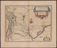
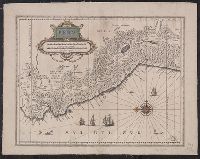
Paragvay, ó, prov. de Rio de la Plata cum regionibus adiacentibus Tvcvman et Sta. Crvz de la Sierra
Description:
Bar scales in "Milliaria Germanica communia" and "Milliaria Gallica communia.", Cross Collection no. 344., From Blaeu's Le theatre du monde ... Amsterdami : Apud Guiljelmum et Iohannem Blaeu, 1635., In French on verso, with caption title "Le Paraguay, ou la province du Rio de la Plata, avec les contrées voysines de Tucuman, & de S. Croix de la Serre" and signature 7K., and Relief shown pictorially.
Publisher:
Guiljelmus Blaeuw excudit,
Subject (Geographic):
Argentina--Maps--Early works to 1800, Paraguay--Maps--Early works to 1800, and Uruguay--Maps--Early works to 1800
Subject (Name):
Blaeu, Joan, 1596-1673. Theatrum orbis terrarum. French and Blaeu, Willem Janszoon, 1571-1638. Theatrum orbis terrarum. French
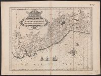
Appears in 1634 and 1635 German eds. of Blaeu's Novus atlas., Bar scales in "Miliaria Germanica communia" and "Miliaria Gallica communia.", Cross Collection no. 354., In German on verso, with caption titles "Königreich Peru" and signature L., Ms. nos. on recto and verso: 349; 348., Oriented with north to the left., and Relief shown pictorially.
Publisher:
Guiljelmus Blaeuw excudit,
Subject (Geographic):
Peru--Maps--Early works to 1800
Subject (Name):
Blaeu, Willem Janszoon, 1571-1638. Theatrum orbis terrarum. German
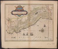
Bar scales in "Milliaria Gallica communia," "Leucae Hispanicae," and "Milliaria Germanica communia.", Cross Collection no. 355., From Blaeu's Le theatre du monde ... Amsterdami : Apud Guiljelmum et Iohannem Blaeu, 1635., In French on verso, with caption title "Chili" and signature 7N., Oriented with north to the left., and Relief shown pictorially.
Publisher:
Guiljelmus Blaeuw excudit,
Subject (Geographic):
Peru--Maps--Early works to 1800
Subject (Name):
Blaeu, Joan, 1596-1673. Theatrum orbis terrarum. French and Blaeu, Willem Janszoon, 1571-1638. Theatrum orbis terrarum. French
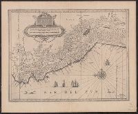
Bar scales in "Miliaria Germanica communia" and "Miliaria Gallica communia.", Blank on verso., From Blaeu's Atlantis appendix (1630 or 1631 eds.)., Mounted on linen. Sheet measures 45 x 54.5 cm., Oriented with north to the left., and Relief shown pictorially.
Publisher:
Guiljelmus Blaeuw excudit,
Subject (Geographic):
Peru--Maps--Early works to 1800
Subject (Name):
Blaeu, Willem Janszoon, 1571-1638. Atlantis appendix
Bar scales in "Miliaria Germanica communia" and "Miliaria Gallica communia.", Blank on verso., From Blaeu's Atlantis appendix (1630 or 1631 eds.)., Mounted on paper, which is mounted on linen. Sheet measures 44.5 x 56.9 cm., Oriented with north to the left., and Relief shown pictorially.
Publisher:
Guiljelmus Blaeuw excudit,
Subject (Geographic):
Peru--Maps--Early works to 1800
Subject (Name):
Blaeu, Willem Janszoon, 1571-1638. Atlantis appendix
Appears in various Dutch eds. of Blaeu's Theatrum orbis terrarum., Bar scales in "Miliaria Germanica communia" and "Miliaria Gallica communia.", In Dutch on verso, with caption title "Peru" and signature Y., Oriented with north to the left., Relief shown pictorially., and Sheet measures 47.3 x 61.4 cm.
Publisher:
Guiljelmus Blaeuw excudit,
Subject (Geographic):
Peru--Maps--Early works to 1800
Subject (Name):
Blaeu, Willem Janszoon, 1571-1638. Theatrum orbis terrarum. Dutch
Blaeu, Willem Janszoon, 1571-1638 Lubin, Eilhard, 1565-1621 Rogiers, Salomon, engraver
Published / Created:
[ca. 1630]
Call Number:
1983 Folio 19
Collection Title:
[Atlas factice of 96 maps by Blaeu, Visscher, Jansson, Hondius and others]
Image Count:
1
Description:
Imperfect: slightly mutilated along fold, with no loss of text. Reinforced along edges with printed waste. Sheet measures 39.1 x 51.2 cm. No. 79 of 92 maps bound together. and Numbered 85 [81, cancelled] on verso.
Publisher:
Guiljelm. Blaeuw excudit
Subject (Geographic):
Pomerania (Poland and Germany) --Maps --Early works to 1800
Blaeu, Willem Janszoon, 1571-1638 Mercator, Gerhard, 1512-1594
Published / Created:
[ca. 1634]
Call Number:
1983 Folio 19
Collection Title:
[Atlas factice of 96 maps by Blaeu, Visscher, Jansson, Hondius and others]
Image Count:
1
Description:
Imperfect: torn along fold, with some loss of text. Sheet measures 39 x 51.3 cm. Reinforced along edges with printed waste. No. 91 of 92 maps bound together. and Numbered 99 [98 and 100, cancelled] on verso.
Publisher:
Apud Guiljel. Blaeu
Subject (Geographic):
Bosnia and Hercegovina --Maps --Early works to 1800 and Croatia --Maps --Early works to 1800