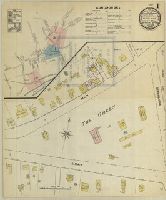
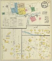
Sanborn fire insurance maps are a rich source of historic data on the urban built environment of North America during the 19th and early 20th centuries. The atlases were created for the purpose of underwriting fire insurance policies, which depended upon accurate and frequently-updated information about construction materials, municipal and transportation infrastructure, industrial and commercial landuse and more. The Yale University Library Map Department scanned its holdings of Sanborn fire insurance maps (consisting primarily of Connecticut towns) in order to make the maps more accessible.
Alternative Title:
July 1889, Branford, Conn.
Description:
"3 sheets, 3438.", Contains information on population, water facilities, and fire department., Includes index of specials., Partial cadastral map., SMLMAPL 766 B72 1889: Sheets disbound. Manuscript corrections on sheet 1. With printing "Sanborn Map of Branford, Conn., for exclusive use of George Palmer, agent ..." on verso of all sheets., and SMLMAPL 766 B72 1889A: Imperfect: title sheet torn along left edge, with no loss of text; sheet 3 wanting. Sheets disbound. "Triplicate" stamp on both sheets. Library of Congress copyright stamp on title sheet.
Subject (Geographic):
Branford (Conn.)--Maps
Subject (Name):
Library of Congress Ownership
Subject (Topic):
Fire risk assessment--Connecticut--Branford--Maps and Real property--Connecticut--Branford--Maps
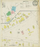
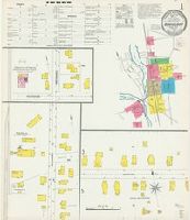
Sanborn fire insurance maps are a rich source of historic data on the urban built environment of North America during the 19th and early 20th centuries. The atlases were created for the purpose of underwriting fire insurance policies, which depended upon accurate and frequently-updated information about construction materials, municipal and transportation infrastructure, industrial and commercial landuse and more. The Yale University Library Map Department scanned its holdings of Sanborn fire insurance maps (consisting primarily of Connecticut towns) in order to make the maps more accessible.
Alternative Title:
Sep. 1895, Branford, Conn.
Description:
"(8212) 4 sheets.", Contains information on population, water facilities, and fire department., Includes index of specials., Partial cadastral map., SMLMAPL 766 B72 1895: Sheets disbound. With printing "Sanborn Map of Branford, Conn., for exclusive use of George Palmer, agent ..." on verso of all sheets., and SMLMAPL 766 B72 1895A: Imperfect: title sheet chipped along right edge, with no loss of text. Sheets disbound. "Triplicate" stamp on both sheets. Library of Congress copyright stamp on title sheet.
Subject (Geographic):
Branford (Conn.)--Maps
Subject (Name):
Library of Congress Ownership
Subject (Topic):
Fire risk assessment--Connecticut--Branford--Maps and Real property--Connecticut--Branford--Maps
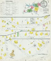
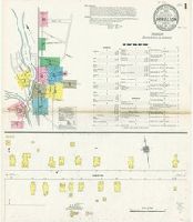
Sanborn fire insurance maps are a rich source of historic data on the urban built environment of North America during the 19th and early 20th centuries. The atlases were created for the purpose of underwriting fire insurance policies, which depended upon accurate and frequently-updated information about construction materials, municipal and transportation infrastructure, industrial and commercial landuse and more. The Yale University Library Map Department scanned its holdings of Sanborn fire insurance maps (consisting primarily of Connecticut towns) in order to make the maps more accessible.
Alternative Title:
Jan. 1901, Branford, Conn.
Description:
"8 sheets, 4430.", Contains information on prevailing winds, population, water facilities, and fire department., Includes index of streets and specials., Partial cadastral map., and SMLMAPL 766 B72 1901: Sheets disbound. "Triplicate" stamp on both sheets. Library of Congress copyright stamp on title sheet.
Subject (Geographic):
Branford (Conn.)--Maps
Subject (Name):
Library of Congress Ownership
Subject (Topic):
Fire risk assessment--Connecticut--Branford--Maps and Real property--Connecticut--Branford--Maps
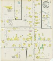
Sanborn fire insurance maps are a rich source of historic data on the urban built environment of North America during the 19th and early 20th centuries. The atlases were created for the purpose of underwriting fire insurance policies, which depended upon accurate and frequently-updated information about construction materials, municipal and transportation infrastructure, industrial and commercial landuse and more. The Yale University Library Map Department scanned its holdings of Sanborn fire insurance maps (consisting primarily of Connecticut towns) in order to make the maps more accessible.
Alternative Title:
July 1908, Branford, Conn.
Description:
"12 sheets, 489.", Contains information on prevailing winds, population, water facilities, and fire department., Includes index of streets and specials., Partial cadastral map., and SMLMAPL 766 B72 1908: Sheets disbound. "Triplicate" stamp on both sheets. Library of Congress copyright stamp on title sheet.
Subject (Geographic):
Branford (Conn.)--Maps
Subject (Name):
Library of Congress Ownership
Subject (Topic):
Fire risk assessment--Connecticut--Branford--Maps and Real property--Connecticut--Branford--Maps
Sanborn fire insurance maps are a rich source of historic data on the urban built environment of North America during the 19th and early 20th centuries. The atlases were created for the purpose of underwriting fire insurance policies, which depended upon accurate and frequently-updated information about construction materials, municipal and transportation infrastructure, industrial and commercial landuse and more. The Yale University Library Map Department scanned its holdings of Sanborn fire insurance maps (consisting primarily of Connecticut towns) in order to make the maps more accessible.
Alternative Title:
Sep. 1895, Clinton, Conn.
Description:
"(8213) 2 sheets.", Contains information on population, prevailing winds, water facilities and fire department., Partial cadastral map., and SMLMAPL 766 C61 1895: Sheets disbound. "Triplicate" stamp on both sheets. Library of Congress copyright manuscript note on title sheet.
Subject (Geographic):
Clinton (Conn.)--Maps
Subject (Name):
Library of Congress Ownership
Subject (Topic):
Fire risk assessment--Connecticut--Clinton--Maps and Real property--Connecticut--Clinton--Maps
Sanborn fire insurance maps are a rich source of historic data on the urban built environment of North America during the 19th and early 20th centuries. The atlases were created for the purpose of underwriting fire insurance policies, which depended upon accurate and frequently-updated information about construction materials, municipal and transportation infrastructure, industrial and commercial landuse and more. The Yale University Library Map Department scanned its holdings of Sanborn fire insurance maps (consisting primarily of Connecticut towns) in order to make the maps more accessible.
Alternative Title:
May 1892, Colchester, Conn.
Description:
"3 sheets. 5187.", Contains information on population, prevailing winds, water facilities and fire department., Includes index of specials., Partial cadastral map., and SMLMAPL 766 C67 1892: Sheets disbound. "Triplicate" stamp on all sheets. Library of Congress copyright manuscript note on title sheet.
Subject (Geographic):
Colchester (Conn.)--Maps
Subject (Name):
Library of Congress Ownership
Subject (Topic):
Fire risk assessment--Connecticut--Colchester--Maps and Real property--Connecticut--Colchester--Maps
Sanborn fire insurance maps are a rich source of historic data on the urban built environment of North America during the 19th and early 20th centuries. The atlases were created for the purpose of underwriting fire insurance policies, which depended upon accurate and frequently-updated information about construction materials, municipal and transportation infrastructure, industrial and commercial landuse and more. The Yale University Library Map Department scanned its holdings of Sanborn fire insurance maps (consisting primarily of Connecticut towns) in order to make the maps more accessible.
Alternative Title:
May 1897, Danielson, Conn.
Description:
"(1229). 5 sheets.", Contains information on population, prevailing winds, water facilities and fire department., Includes index of streets and specials., Partial cadastral map., and SMLMAPL 766 D228 1897: Sheets disbound. "Triplicate" stamp on all sheets. Library of Congress copyright manuscript note on title sheet.
Subject (Geographic):
Killingly (Conn. : Town)--Maps
Subject (Name):
Library of Congress Ownership
Subject (Topic):
Fire risk assessment--Connecticut--Killingly (Town)--Maps and Real property--Connecticut--Killingly (Town)--Maps
Sanborn fire insurance maps are a rich source of historic data on the urban built environment of North America during the 19th and early 20th centuries. The atlases were created for the purpose of underwriting fire insurance policies, which depended upon accurate and frequently-updated information about construction materials, municipal and transportation infrastructure, industrial and commercial landuse and more. The Yale University Library Map Department scanned its holdings of Sanborn fire insurance maps (consisting primarily of Connecticut towns) in order to make the maps more accessible.
Alternative Title:
July 1903, Danielson, Conn.
Description:
"8 sheets. 6386.", Contains information on population, prevailing winds, water facilities and fire department., Includes index of streets and specials., Partial cadastral map., and SMLMAPL 766 D228 1903: Sheets disbound. "Triplicate" stamp on all sheets. Library of Congress copyright and Map Division stamps on title sheet.
Subject (Geographic):
Killingly (Conn. : Town)--Maps
Subject (Name):
Library of Congress Ownership and Library of Congress. Map Division Stamp
Subject (Topic):
Fire risk assessment--Connecticut--Killingly (Town)--Maps and Real property--Connecticut--Killingly (Town)--Maps
Sanborn fire insurance maps are a rich source of historic data on the urban built environment of North America during the 19th and early 20th centuries. The atlases were created for the purpose of underwriting fire insurance policies, which depended upon accurate and frequently-updated information about construction materials, municipal and transportation infrastructure, industrial and commercial landuse and more. The Yale University Library Map Department scanned its holdings of Sanborn fire insurance maps (consisting primarily of Connecticut towns) in order to make the maps more accessible.
Alternative Title:
May 1911, Danielson, Conn.
Description:
"3701. 10 sheets.", "Including Quinebaug & Quebec.", Contains information on population, prevailing winds, water facilities and fire department., Includes index of streets and specials., Partial cadastral map., and SMLMAPL 766 D228 1911: Sheets disbound. Library of Congress copyright stamp on title sheet.
Subject (Geographic):
Killingly (Conn. : Town)--Maps
Subject (Name):
Library of Congress Ownership
Subject (Topic):
Fire risk assessment--Connecticut--Killingly (Town)--Maps and Real property--Connecticut--Killingly (Town)--Maps
Sanborn fire insurance maps are a rich source of historic data on the urban built environment of North America during the 19th and early 20th centuries. The atlases were created for the purpose of underwriting fire insurance policies, which depended upon accurate and frequently-updated information about construction materials, municipal and transportation infrastructure, industrial and commercial landuse and more. The Yale University Library Map Department scanned its holdings of Sanborn fire insurance maps (consisting primarily of Connecticut towns) in order to make the maps more accessible.
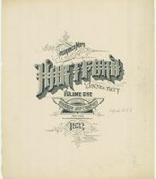
Alternative Title:
Insurance maps of Hartford and West Hartford, Connecticut
Description:
"(5407)... Vol. 1"; "(5500)... Vol. 2"; "(5610)... Vol. 3.", Contains information on population, prevailing winds, water facilities and fire department., Includes index of streets and specials., Partial cadastral map., Sheets 1-12 and 17-18 are duplicated as "skeleton" sheets., SMLMAPL 766 H26 1922: Sheets disbound. Library of Congress copyright manuscript notes on title sheets., and Volumes 1 and 2 dated 1922 ; Volume 3 dated 1923.
Subject (Geographic):
Hartford (Conn.)--Maps and West Hartford (Conn.)--Maps
Subject (Name):
Library of Congress Ownership
Subject (Topic):
Fire risk assessment--Connecticut--Hartford--Maps, Fire risk assessment--Connecticut--West Hartford--Maps, Real property--Connecticut--Hartford--Maps, and Real property--Connecticut--West Hartford--Maps