Skip to search
Skip to main content
Skip to first result
Search
You Searched For
Format
cartographic
Language
English
Publication Place
Chicago :
New Search
Search Results
Published / Created:
1874
Call Number:
806am C43 1874
Container / Volume:
BRBL_00549
Image Count:
1
Resource Type:
Maps, Atlases & Globes
Description:
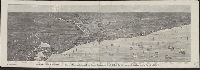
"Extra supplement to THE LAND OWNER for May 1874".
Publisher:
J.M Wing & Co.,
Subject (Geographic):
Chicago (Illinois)--Maps
Found in:
Beinecke Rare Book and Manuscript Library > Bird's-eye view of Chicago and its environs : showing a distance of 45 miles on Lake Michigan, and 26 miles westward / drawn by R.W. Wallis.
Published / Created:
1906
Call Number:
806 C43 1906
Container / Volume:
BRBL_00548
Image Count:
2
Resource Type:
Maps, Atlases & Globes
Alternative Title:
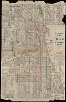
Blanchard's map of Chicago
Description:
Imperfect: Mutilated with loss of text: Ms. notations in blue. and Shows railroad and street railway lines.
Publisher:
Rufus Blanchard,
Subject (Geographic):
Chicago (Illinois)--Maps
Found in:
Beinecke Rare Book and Manuscript Library > Blanchard's map of Chicago : with the new street names.
Published / Created:
1887
Call Number:
806 C43 1887
Container / Volume:
BRBL_00548
Image Count:
1
Resource Type:
Maps, Atlases & Globes
Description:
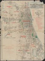
Advert. for "Baird & Bradley Real Estate, Loan & Rental Agency".
Publisher:
Rufus Blanchard,
Subject (Geographic):
Chicago (Illinois)--Maps
Found in:
Beinecke Rare Book and Manuscript Library > Blanchard's map of Chicago and environs.
Creator:
Published / Created:
c1903.
Call Number:
764 B65 1903
Container / Volume:
BRBL_00456
Image Count:
1
Resource Type:
Maps, Atlases & Globes
Description:
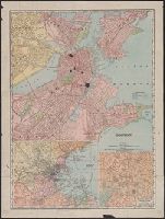
Includes insets: "Business portion of Boston" and "Environs of Boston." and Map originally part of an atlas.
Publisher:
Rand-McNally,
Subject (Geographic):
Boston (Mass.)--Maps and Boston Metropolitan Area (Mass.)--Maps
Subject (Topic):
Central business districts--Massachusetts--Boston--Maps
Found in:
Beinecke Rare Book and Manuscript Library > Boston.
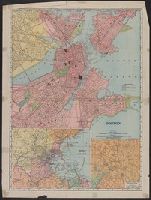
Creator:
Published / Created:
1907
Call Number:
764 B65 1907A
Container / Volume:
BRBL_00456
Image Count:
2
Resource Type:
Maps, Atlases & Globes
Alternative Title:
Rand, McNally & Co.'s new business atlas map of Boston
Description:
2 insets: Environs of Boston, Business portion of Boston. and Verso: Trolley map of Massachusetts, tourist information, text and advertising.
Publisher:
Rand McNally & Co.,
Subject (Geographic):
Boston (Mass.)--Maps and Massachusetts--Maps
Found in:
Beinecke Rare Book and Manuscript Library > Boston.
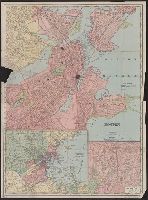
Creator:
Published / Created:
1909
Call Number:
764 B65 1909M
Container / Volume:
BRBL_00456A
Image Count:
2
Resource Type:
Maps, Atlases & Globes
Description:
Includes insets: Environs of Boston and Business portion of Boston., On verso: Trolley maps of Massachusetts, 21 x 39 cm., and Part of Rand, McNally & Co.'s new business atlas map of Boston.
Publisher:
Rand-McNally,
Subject (Geographic):
Boston (Mass.)--Maps and Massachusetts--Maps
Subject (Topic):
Central business districts--Massachusetts--Boston--Maps
Found in:
Beinecke Rare Book and Manuscript Library > Boston.
Published / Created:
1909
Call Number:
739gme 1909
Container / Volume:
BRBL_00393
Image Count:
1
Resource Type:
Maps, Atlases & Globes
Description:
"Rand, McNally & Co.'s New Business Atlas Map of British Columbia.", Includes inset map: Northern part of British Columbia., and Index to railways overprinted in red in lower right; index to cities by population in left margin.
Publisher:
Rand McNally & Co., Map Publishers and Engravers,
Subject (Geographic):
British Columbia--Maps
Found in:
Beinecke Rare Book and Manuscript Library > British Columbia [Railroads].
Creator:
Published / Created:
[1910?]
Call Number:
754gme 1910A
Container / Volume:
BRBL_00420
Image Count:
1
Resource Type:
Maps, Atlases & Globes
Description:
Includes mileage charts of railways.
Publisher:
The Company,
Subject (Name):
Buffalo, Rochester, and Pittsburgh Railway Company and Buffalo, Rochester, and Pittsburgh Railway Company--Maps
Subject (Topic):
Railroads--New York (State)--Maps and Railroads--Pennsylvania--Maps
Found in:
Beinecke Rare Book and Manuscript Library > Buffalo, Rochester and Pittsburgh Railway and connections / Rand McNally & Co.
Published / Created:
1910
Call Number:
806 C43 1910
Container / Volume:
BRBL_00548
Image Count:
1
Resource Type:
Maps, Atlases & Globes
Description:
"Bureau of Information Chicago Association of Commerce 22 Congress Street" noted in red.
Publisher:
Rand McNally & Co.,
Subject (Geographic):
Chicago (Illinois)--Maps
Found in:
Beinecke Rare Book and Manuscript Library > Business portion of the city of Chicago.
Published / Created:
1968
Call Number:
75 1868A
Container / Volume:
BRBL_00404
Image Count:
2
Resource Type:
Maps, Atlases & Globes
Description:
"Engraved by Jerome T. Gouget at R. Blanchard's Map Establishment, No. 146 Lake St. Chicago Ill.", Hand colored oak entwined border vignettes, accompanying covers., Inset: A map of the Wester, and Verso: Western half of the U.S. with inset of "Map of the World."
Publisher:
Rufus Blanchard,
Subject (Geographic):
United States--Maps
Found in:
Beinecke Rare Book and Manuscript Library > Cabinet Map of the United States and Territories / compiled from government maps and published by Rufus Blanchard.
Branch:v1.61.6 ,Deployed:2024-06-12T09:55:36-04:00