Skip to search
Skip to main content
Skip to first result
Search
You Searched For
Format
cartographic
Publication Place
Chicago :
New Search
Search Results
Creator:
Published / Created:
1891, c1889.
Call Number:
75gme 1891
Container / Volume:
BRBL_00414
Image Count:
2
Resource Type:
Maps, Atlases & Globes
Alternative Title:
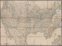
New official railroad map of the United States, Canada and Mexico.
Description:
Includes 9 insets., Northern Canada and southern Mexico not shown., On verso: Indexes and publisher's advertisements., and Relief shown by hachures.
Publisher:
Rand McNally,
Subject (Topic):
Railroads--Canada--Maps, Railroads--Mexico, North--Maps, Railroads--North America--Maps, and Railroads--United States--Maps
Found in:
Beinecke Rare Book and Manuscript Library > Rand McNally & Co.'s new official railroad map of the United States, Canada, and Mexico.
Creator:
Published / Created:
c1881.
Call Number:
804 1881
Container / Volume:
BRBL_00543
Image Count:
1
Resource Type:
Maps, Atlases & Globes
Alternative Title:
Rand McNally & Co.'s Ohio and Sectional and township map of Ohio
Description:
Meridians Greenwich, Washington.
Publisher:
Rand, McNally & Co.,
Subject (Geographic):
Ohio--Maps
Found in:
Beinecke Rare Book and Manuscript Library > Rand McNally & Co.'s new sectional and township map of Ohio.
Published / Created:
1910
Call Number:
806 C43 1910A
Container / Volume:
BRBL_00548
Image Count:
2
Resource Type:
Maps, Atlases & Globes
Alternative Title:
Street number guide map of the principal part of Chicago
Description:
Includes Index to railroads. and Rand McNally & Co.'s street guide map of Chicago and suburbs showing the city limits on verso.
Publisher:
Rand McNally & Co.,
Subject (Geographic):
Chicago (Illinois)--Maps
Found in:
Beinecke Rare Book and Manuscript Library > Rand McNally & Co.'s street number guide map of the principal part of Chicago.
Published / Created:
1915
Call Number:
779 W27 1915
Container / Volume:
BRBL_00505A
Image Count:
2
Resource Type:
Maps, Atlases & Globes
Description:
Part of the "Rand McNally Vest Pocket Maps of the Principal Cities" series. and Verso: "Washington D.C. points of interest, streets, etc.".
Publisher:
Rand McNally & Co. ,
Subject (Geographic):
Washington (D.C.)--Maps
Found in:
Beinecke Rare Book and Manuscript Library > Rand McNally New commercial atlas map of Washington D.C.
Published / Created:
1892
Call Number:
806 C43 1892
Container / Volume:
BRBL_00548
Image Count:
1
Resource Type:
Maps, Atlases & Globes
Description:
Inset: principal business districts, index to railroads.
Publisher:
Rand McNally & Co.,
Subject (Geographic):
Chicago (Illinois)--Maps
Found in:
Beinecke Rare Book and Manuscript Library > Rand McNally and Co.'s new map of Chicago and suburbs / showing the location of the World's Columbian Exposition, streets, parks, boulevards, railroads, street car lines, etc.
Published / Created:
1910
Call Number:
773 1918
Image Count:
2
Resource Type:
Maps, Atlases & Globes
Description:
List of New Jersey railroads denoted in red.
Publisher:
Rand McNally & Co. ,
Subject (Geographic):
New Jersey--Maps
Found in:
Beinecke Rare Book and Manuscript Library > Rand McNally new commercial atlas map of New Jersey.
Published / Created:
[1890?].
Call Number:
75gme 1890
Container / Volume:
BRBL_00414
Image Count:
1
Resource Type:
Maps, Atlases & Globes
Description:
"682E."
Publisher:
Rand McNally & Co.,
Subject (Geographic):
Canada--Maps and United States--Maps
Found in:
Beinecke Rare Book and Manuscript Library > Rand McNally new official railroad map of the United States and Southern Canada.
Published / Created:
1920
Call Number:
754gmb 1920A
Container / Volume:
BRBL_00419
Image Count:
1
Resource Type:
Maps, Atlases & Globes
Description:
Adjoining map district numbers noted in red along map margins. and Shows highway systems, mileages between towns, cities, and trail junctions, trail markings, hotels, businesses, and population figures.
Publisher:
Rand McNally & Co.,
Subject (Geographic):
Middle Atlantic States--Maps
Found in:
Beinecke Rare Book and Manuscript Library > Rand McNally official 1920 auto trails map, District number 7 : Pennsylvania, New Jersey, Southern New York, Northern Delaware, Northern Maryland, Northern Virginia, North East W. Virginia / copyright by Rand McNally & Company.
Creator:
Published / Created:
c1924.
Call Number:
834gmb 1924
Container / Volume:
BRBL_00591
Image Count:
2
Resource Type:
Maps, Atlases & Globes
Alternative Title:
Auto trails map of Colorado, Auto trails map, Denver and vicinity., Official 1924, auto trails map of Colorado, and Rand McNally detailed auto trails map, Denver and vicinity.
Description:
Distributed by the Continental Oil Company., On verso: Rand McNally detailed auto trails map, Denver and vicinity. Scale [ca. 1:500,000]., Relief shown by hachures and spot heights., and Shows trail and highway markings.
Publisher:
Rand McNally & Company,
Subject (Geographic):
Colorado--Maps
Subject (Name):
Continental Oil Company
Subject (Topic):
Roads--Colorado--Denver Region--Maps and Roads--Colorado--Maps
Found in:
Beinecke Rare Book and Manuscript Library > Rand McNally official 1924 : auto trails map of Colorado.
Published / Created:
[1930]
Call Number:
97 1930
Container / Volume:
BRBL_00678
Image Count:
2
Resource Type:
Maps, Atlases & Globes
Alternative Title:
Popular map of Peru, Ecuador, and western Brazil
Description:
Inset : Galápagos Islands. and Panel title: Peru-Ecuador and Western Brazil Pocket Map.
Publisher:
Rand McNally & Co.,
Subject (Geographic):
Peru--Maps
Found in:
Beinecke Rare Book and Manuscript Library > Rand McNally popular map of Peru, Ecuador, and western Brazil.
Branch:v1.61.6 ,Deployed:2024-06-12T09:55:37-04:00