Search
You Searched For
Search Results
- Creator:
- Jefferys, Thomas, d. 1771
- Call Number:
- C6 033c
- Collection Title:
- The natural and civil history of the French dominions in North and South America : with an
- Image Count:
- 1
- Resource Type:
- Maps, Atlases & Globes
- Description:
- Plate between p. 2-3.
- Subject (Geographic):
- Atlantic Ocean--Charts, maps, etc., Atlantic Ocean--Maps--Early works to 1800, and Santo Domingo (Dominican Republic)
- Collection Created:
- London, Printed for T. Jeffreys, 1761
- Found in:
- Beinecke Rare Book and Manuscript Library > The island of Hispaniola called by the French St. Domingo. Subject to France and Spain. from the best authorities by Thomas Jeffreys, geographer to his Royal Highness the Prince of Wales
- Call Number:
- 1973 Folio 114
- Collection Title:
- The English pilot: describing the West-India navigation, from Hudson's-Bay to the river Amazones
- Image Count:
- 1
- Resource Type:
- Maps, Atlases & Globes
- Subject (Geographic):
- Atlantic Ocean --Maps --Early works to 1800, Jamaica --Maps --Early works to 1800, and West Indies --Maps --Early works to 1800
- Subject (Topic):
- Navigation --Early works to 1800, Pilot guides --Atlantic Coast (U.S.) --Early works to 1800, and Pilot guides --Caribbean Area --Early works to 1800
- Collection Created:
- London : Printed for W. and J. Mount, T. Page and son, on Tower-Hill, MDCCLIX [1759]
- Found in:
- Beinecke Rare Book and Manuscript Library > The island of Jamaica
- Creator:
- Waghenaer, Lucas Janszoon, 1534 or 5-1606
- Published / Created:
- ann. 1605.
- Call Number:
- 1976 Folio 46
- Image Count:
- 1
- Resource Type:
- Maps, Atlases & Globes
- Alternative Title:
- Mariners mirrour.
- Description:
- Map oriented with North at bottom left.
- Publisher:
- Jodocus Hondius excudit,
- Subject (Geographic):
- Great Britain --Maps --Early works to 1800, Netherlands --Maps --Early works to 1800, and North Sea --Maps --Early works to 1800
- Found in:
- Beinecke Rare Book and Manuscript Library > The mariners mirrovr wherin may playnly be seen the courses, heights, distances, depths, sounding, flouds and ebs, risings of lands, rocks ... of the harbouroughs, havens and ports of the greatest part of Europe: ... together w.th the rules and instrumeíÄ
- Call Number:
- 1977 +392
- Collection Title:
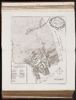
- A survey of the cities of London and Westminster : containing the original, antiquity, increase
- Image Count:
- 1
- Resource Type:
- Maps, Atlases & Globes
- Description:
- Plate between p. 44-45.
- Subject (Geographic):
- London (England)--History
- Collection Created:
- London : Printed for A. Churchill, J. Knapton, R. Knaplock, J. Walthoe [and 6 others], 1720
- Found in:
- Beinecke Rare Book and Manuscript Library > The parish of St. Johns Wapping
- Creator:
- Fee, Chas E
- Published / Created:
- c1891
- Call Number:
- Zc86 893scd
- Collection Title:
- Appletons' guide-book to Alaska and the northwest coast ...
- Image Count:
- 1
- Resource Type:
- Maps, Atlases & Globes
- Description:
- Folded map in back pocket.
- Publisher:
- Poole Bros
- Subject (Geographic):
- Alaska. and Northwest Coast of North America
- Collection Created:
- New York, D. Appleton and Company, 1899
- Found in:
- Beinecke Rare Book and Manuscript Library > The route of the Alaska excursion steamers
- Creator:
- Bry, Theodor de, 1528-1598
- Call Number:
- 1976 Folio 110
- Collection Title:
- The mariners mirrovr wherin may playnly be seen the courses, heights, distances, depths, sounding
- Image Count:
- 1
- Resource Type:
- Maps, Atlases & Globes
- Subject (Geographic):
- Dover (England), England, English Channel, and Isle of Wight (England)
- Collection Created:
- [London, J. Charlewood? 1588]
- Found in:
- Beinecke Rare Book and Manuscript Library > The sea coastes of England betweene the Ile of Wight & Douer, with the principal hauens thereof according to their situation and appearing
- Creator:
- Bry, Theodor de, 1528-1598
- Call Number:
- 1976 Folio 110
- Collection Title:
- The mariners mirrovr wherin may playnly be seen the courses, heights, distances, depths, sounding
- Image Count:
- 1
- Resource Type:
- Maps, Atlases & Globes
- Subject (Geographic):
- Bristol Channel, England, and English Channel
- Collection Created:
- [London, J. Charlewood? 1588]
- Found in:
- Beinecke Rare Book and Manuscript Library > The sea coastes of England, from the Sorlinges by the landes end to Plymouth with the hauens and harbrowghes