Skip to search
Skip to main content
Skip to first result
Search
You Searched For
Extent of Digitization
Partially digitized
Resource Type
Maps, Atlases & Globes
Language
English
New Search
Search Results
Creator:
Published / Created:
1720
Call Number:
1973 Folio 114
Collection Title:
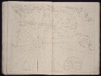
The English pilot: describing the West-India navigation, from Hudson's-Bay to the river Amazones
Image Count:
1
Resource Type:
Maps, Atlases & Globes
Subject (Geographic):
Atlantic Ocean --Maps --Early works to 1800, Casco Bay (Me.) --Maps --Early works to 1800, Maine --Maps --Early works to 1800, and New England --Maps --Early works to 1800
Subject (Topic):
Navigation --Early works to 1800, Pilot guides --Atlantic Coast (U.S.) --Early works to 1800, and Pilot guides --Caribbean Area --Early works to 1800
Collection Created:
London : Printed for W. and J. Mount, T. Page and son, on Tower-Hill, MDCCLIX [1759]
Found in:
Beinecke Rare Book and Manuscript Library > The harbour of Casco Bay and islands adjacent
Call Number:
1973 Folio 114
Collection Title:
The English pilot: describing the West-India navigation, from Hudson's-Bay to the river Amazones
Image Count:
1
Resource Type:
Maps, Atlases & Globes
Subject (Geographic):
Atlantic Ocean --Maps --Early works to 1800, Jamaica --Maps --Early works to 1800, and West Indies --Maps --Early works to 1800
Subject (Topic):
Navigation --Early works to 1800, Pilot guides --Atlantic Coast (U.S.) --Early works to 1800, and Pilot guides --Caribbean Area --Early works to 1800
Collection Created:
London : Printed for W. and J. Mount, T. Page and son, on Tower-Hill, MDCCLIX [1759]
Found in:
Beinecke Rare Book and Manuscript Library > The island of Jamaica
Creator:
Published / Created:
ann. 1605.
Call Number:
1976 Folio 46
Image Count:
1
Resource Type:
Maps, Atlases & Globes
Alternative Title:
Mariners mirrour.
Description:
Map oriented with North at bottom left.
Publisher:
Jodocus Hondius excudit,
Subject (Geographic):
Great Britain --Maps --Early works to 1800, Netherlands --Maps --Early works to 1800, and North Sea --Maps --Early works to 1800
Found in:
Beinecke Rare Book and Manuscript Library > The mariners mirrovr wherin may playnly be seen the courses, heights, distances, depths, sounding, flouds and ebs, risings of lands, rocks ... of the harbouroughs, havens and ports of the greatest part of Europe: ... together w.th the rules and instrumeíÄ
Creator:
Published / Created:
1841
Call Number:
1977 Folio 193
Collection Title:
A new general atlas of modern geography, consisting of a complete collection of maps of the four
Image Count:
1
Resource Type:
Maps, Atlases & Globes
Subject (Topic):
Cosmology --Pictorial works and Solar system --Pictorial works
Collection Created:
London, Published by James Wyld [1845?]
Found in:
Beinecke Rare Book and Manuscript Library > The phenomena of the universe ...
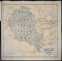
Published / Created:
1884
Call Number:
Zc10 885up
Collection Title:
Range and ranch cattle
Image Count:
1
Resource Type:
Maps, Atlases & Globes
Description:
Verso blank.
Subject (Geographic):
Arizona, Colorado, Dakota Territory, Idaho, Kansas, Montana, Nebraska, Nevada, New Mexico, Oregon, Texas, Utah, Washington (State), and Wyoming
Subject (Name):
Nimmo, Joseph, 1837-1909
Subject (Topic):
Cattle --West (U.S.) and Ranches --West (U.S.)
Collection Created:
[Washington : Govt. Print. Off., 1885]
Found in:
Beinecke Rare Book and Manuscript Library > The range and ranch cattle area of the United States
Creator:
Call Number:
1976 Folio 110
Collection Title:
The mariners mirrovr wherin may playnly be seen the courses, heights, distances, depths, sounding
Image Count:
1
Resource Type:
Maps, Atlases & Globes
Subject (Geographic):
Dover (England), England, English Channel, and Isle of Wight (England)
Collection Created:
[London, J. Charlewood? 1588]
Found in:
Beinecke Rare Book and Manuscript Library > The sea coastes of England betweene the Ile of Wight & Douer, with the principal hauens thereof according to their situation and appearing
Creator:
Call Number:
1976 Folio 110
Collection Title:
The mariners mirrovr wherin may playnly be seen the courses, heights, distances, depths, sounding
Image Count:
1
Resource Type:
Maps, Atlases & Globes
Subject (Geographic):
Bristol Channel, England, and English Channel
Collection Created:
[London, J. Charlewood? 1588]
Found in:
Beinecke Rare Book and Manuscript Library > The sea coastes of England, from the Sorlinges by the landes end to Plymouth with the hauens and harbrowghes
Creator:
Call Number:
1976 Folio 110
Collection Title:
The mariners mirrovr wherin may playnly be seen the courses, heights, distances, depths, sounding
Image Count:
1
Resource Type:
Maps, Atlases & Globes
Subject (Geographic):
Portugal
Collection Created:
[London, J. Charlewood? 1588]
Found in:
Beinecke Rare Book and Manuscript Library > The sea coastes of Portugal betwene Camino & Montego eue as the countrie there aboutes is lying and situated with all the havens thereof exactly done, and corected with great dilligence
Creator:
Published / Created:
1821
Call Number:
1996 142
Collection Title:
United States directory for the use of travellers and merchants : giving an account of the
Image Count:
1
Resource Type:
Maps, Atlases & Globes
Description:
Verso blank.
Publisher:
M. Carey & son
Subject (Geographic):
United States --Guidebooks
Collection Created:
Philadelphia : Printed by James Maxwell ..., 1822
Found in:
Beinecke Rare Book and Manuscript Library > United States of America compiled from the latest & best authorities
Call Number:
1973 Folio 114
Collection Title:
The English pilot: describing the West-India navigation, from Hudson's-Bay to the river Amazones
Image Count:
1
Resource Type:
Maps, Atlases & Globes
Subject (Geographic):
Atlantic Ocean --Maps --Early works to 1800, Maryland --Maps --Early works to 1800, New Jersey --Maps --Early works to 1800, and Virginia --Maps --Early works to 1800
Subject (Topic):
Navigation --Early works to 1800, Pilot guides --Atlantic Coast (U.S.) --Early works to 1800, and Pilot guides --Caribbean Area --Early works to 1800
Collection Created:
London : Printed for W. and J. Mount, T. Page and son, on Tower-Hill, MDCCLIX [1759]
Found in:
Beinecke Rare Book and Manuscript Library > Virginia, Maryland, Pennsilvania, east & west New Jarsey
Branch:v1.61.8 ,Deployed:2024-06-20T11:14:55-04:00