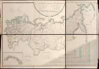
Pi︠a︡dyshev, Vasiliĭ Petrovich, 1768-1835. Пядышев, Василий Петрович, 1768-1835.
Published / Created:
1820-1827.
Call Number:
EEdb 828P
Image Count:
1
Resource Type:
Maps, Atlases & Globes
Alternative Title:
Atlas géographique de l'empire de Russie, du royaume de Pologne and du grand duché de Finlande and Географическій атлас Россійской Имперіи Царства Польскаго и Великаго Княжества Финляндскаго : расположенный по губерніям на 80 листах ... с генеральною картою ... / сочинен по новѣйшим и достовѣрным свѣденіям ... Пядышевым, начат 1820-го, окончен 1827-го года = Atlas géographique de l'empire de Russie, du royaume de Pologne et du grand duché de Finlande ; divisé en gouvernements ... ; avec une carte générale ... / composé ... par ... Pi︠a︡discheff ...
Description:
Captions and place names in Russian and Polish or in Russian and French., Relief shown by spot heights., and Some maps composed of two or more leaves hinged with cloth.
Publisher:
[publisher not identified],
Subject (Geographic):
Soviet Union.--(OCoLC)fst01210281 and Soviet Union--Maps.
For fuller description see collation slip in volume. and Imperfect: fol. 116 (blank) wanting.
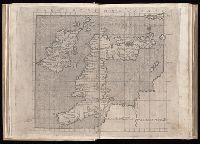
Publisher:
Nicolaus Laurentii, Alamanus,
Subject (Geographic):
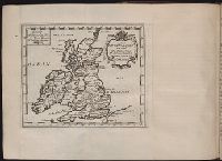
Corsica (France)--Maps--Early works to 1800, England--Maps--Early works to 1800, Ireland--Maps--Early works to 1800, Italy--Maps--Early works to 1800, and Sardinia (Italy)--Maps--Early works to 1800
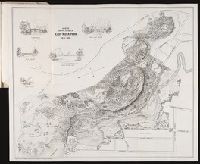
A report to the commissioners on lay-out of East Rock Park / by Donald G. Mitchell, LL.D
Image Count:
1
Resource Type:
Maps, Atlases & Globes
Abstract:
Five inset illustrations: Timber Bridge at Rock Lane / Rock-Lane Bridge / Iron Bridge at Rock Lane / Hanging Foot-Bridge over Whitney Dam / Dairy House
Description:
At foot: Lith by L.S. Punderson, New Haven, CT, Reduced from the large colored sketch which accompanied report, and Tipped in at end of report