Skip to search
Skip to main content
Skip to first result
Search
You Searched For
Extent of Digitization
Partially digitized
Resource Type
Maps, Atlases & Globes
New Search
Search Results
Creator:
Call Number:
1976 Folio 110
Collection Title:
The mariners mirrovr wherin may playnly be seen the courses, heights, distances, depths, sounding
Image Count:
1
Resource Type:
Maps, Atlases & Globes
Subject (Geographic):
Dover (England), England, English Channel, and Isle of Wight (England)
Collection Created:
[London, J. Charlewood? 1588]
Found in:
Beinecke Rare Book and Manuscript Library > The sea coastes of England betweene the Ile of Wight & Douer, with the principal hauens thereof according to their situation and appearing
Creator:
Call Number:
1976 Folio 110
Collection Title:
The mariners mirrovr wherin may playnly be seen the courses, heights, distances, depths, sounding
Image Count:
1
Resource Type:
Maps, Atlases & Globes
Subject (Geographic):
Bristol Channel, England, and English Channel
Collection Created:
[London, J. Charlewood? 1588]
Found in:
Beinecke Rare Book and Manuscript Library > The sea coastes of England, from the Sorlinges by the landes end to Plymouth with the hauens and harbrowghes
Creator:
Call Number:
1976 Folio 110
Collection Title:
The mariners mirrovr wherin may playnly be seen the courses, heights, distances, depths, sounding
Image Count:
1
Resource Type:
Maps, Atlases & Globes
Description:
Theodor de Bry, Sculp.
Subject (Geographic):
Bordeaux (France) and Garonne River (Spain and France)
Collection Created:
[London, J. Charlewood? 1588]
Found in:
Beinecke Rare Book and Manuscript Library > The sea coastes of the landes of Poyctou and Bordeaux ...as they shew and appeare, when you sayle there alongst betweene Picquelier and the River of Bordeaux called the Garonne
Creator:
Published / Created:
1775
Call Number:
1977 Folio 96
Collection Title:
The West-India atlas: or, A compendious description of the West-Indies: illustrated with forty
Image Count:
1
Resource Type:
Maps, Atlases & Globes
Subject (Geographic):
Turks Island Passage (Turks and Caicos Islands)
Subject (Topic):
Nautical charts
Collection Created:
London, Printed for Robert Sayer and John Bennett, Fleet-Street, 1775
Found in:
Beinecke Rare Book and Manuscript Library > Turks Islands, from a survey made in 1753, by the the sloops l'Aigle and l'Emeraude, by order of the French Governor of Hispaniola, with improvements from observations, made in 1770, in the Sr. Edward Hawke Kings Schooner
Creator:
Published / Created:
[1840]
Call Number:
1973 Folio 105
Collection Title:
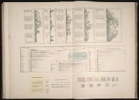
Atlas fisico y politico de la Republica de Venezuela ... por ... Agustin Codazzi ...
Image Count:
1
Resource Type:
Maps, Atlases & Globes
Description:
Caption from index., Double page width, tab mounted., and Lith. de Thierry Fres. Cite Bergere 1 a Paris, printers.
Subject (Geographic):
Venezuela --Statistics
Subject (Topic):
Mountains --Venezuela, Physical geography --Venezuela, and Rivers --Venezuela
Collection Created:
Caracas,
Found in:
Beinecke Rare Book and Manuscript Library > Un cuadro de alturas que comprende las de las cordilleras de Merida, de la costa de Caracas, Coro, Cumana y Margarita, y ultimamente las del sistema de la Parima. Otro cuadro comparativo de la superficie y poblacion de cada provincia. Otro de los principa
Creator:
Published / Created:
1821
Call Number:
1996 142
Collection Title:
United States directory for the use of travellers and merchants : giving an account of the
Image Count:
1
Resource Type:
Maps, Atlases & Globes
Description:
Verso blank.
Publisher:
M. Carey & son
Subject (Geographic):
United States --Guidebooks
Collection Created:
Philadelphia : Printed by James Maxwell ..., 1822
Found in:
Beinecke Rare Book and Manuscript Library > United States of America compiled from the latest & best authorities
Call Number:
1973 Folio 114
Collection Title:
The English pilot: describing the West-India navigation, from Hudson's-Bay to the river Amazones
Image Count:
1
Resource Type:
Maps, Atlases & Globes
Subject (Geographic):
Atlantic Ocean --Maps --Early works to 1800, Maryland --Maps --Early works to 1800, New Jersey --Maps --Early works to 1800, and Virginia --Maps --Early works to 1800
Subject (Topic):
Navigation --Early works to 1800, Pilot guides --Atlantic Coast (U.S.) --Early works to 1800, and Pilot guides --Caribbean Area --Early works to 1800
Collection Created:
London : Printed for W. and J. Mount, T. Page and son, on Tower-Hill, MDCCLIX [1759]
Found in:
Beinecke Rare Book and Manuscript Library > Virginia, Maryland, Pennsilvania, east & west New Jarsey
Branch:v1.61.8 ,Deployed:2024-06-20T11:14:46-04:00