Skip to search
Skip to main content
Skip to first result
Search
You Searched For
Extent of Digitization
Partially digitized
Resource Type
Maps, Atlases & Globes
New Search
Search Results
Creator:
Published / Created:
1850
Call Number:
1975 Folio 26
Collection Title:
A new universal atlas containing maps of the various empires, kingdoms, states and republics of the
Image Count:
1
Resource Type:
Maps, Atlases & Globes
Collection Created:
Philadelphia, Thomas, Cowperthwait & Co., No. 253 Market street, 1852
Found in:
Beinecke Rare Book and Manuscript Library > A new universal atlas containing maps of the various empires, kingdoms, states and republics of the world ...
Creator:
Published / Created:
1836
Call Number:
1976 Folio 98
Collection Title:
A new universal atlas, containing maps of the various empires, kingdoms, states and republics of
Image Count:
1
Resource Type:
Maps, Atlases & Globes
Description:
Illustrated vignette depicting the first landing of Columbus in the new world.
Collection Created:
Philadelphia, Published by the author, 1836
Found in:
Beinecke Rare Book and Manuscript Library > A new universal atlas, containing maps of the various empires, kingdoms, states and republics of the world ...
Call Number:
1977 Folio 78
Collection Title:
A New and accurate chart of the West-India Islands and coast, with the gulf passage through the New
Image Count:
1
Resource Type:
Maps, Atlases & Globes
Alternative Title:
Petit Guave in the island of Hispaniola, pl. 32
Subject (Geographic):
Hispaniola
Subject (Topic):
Nautical charts
Collection Created:
London, Printed for Robert Sayer and John Bennett, Fleet-Street, 1779
Found in:
Beinecke Rare Book and Manuscript Library > A plan of Fort St. Louis harbour on the south side of Hispaniola, pl. 31.
Call Number:
1977 Folio 78
Collection Title:
A New and accurate chart of the West-India Islands and coast, with the gulf passage through the New
Image Count:
1
Resource Type:
Maps, Atlases & Globes
Alternative Title:
Plan of the bay and town of Bayaha or Port Dauphin in the island of Hispaniola, pl. 37.
Collection Created:
London, Printed for Robert Sayer and John Bennett, Fleet-Street, 1779
Found in:
Beinecke Rare Book and Manuscript Library > A plan of Monte-Christe Bay with the Seven Brothers on the north coast of St. Domingo, pl. 38
Call Number:
1977 Folio 78
Collection Title:
A New and accurate chart of the West-India Islands and coast, with the gulf passage through the New
Image Count:
1
Resource Type:
Maps, Atlases & Globes
Alternative Title:
A plan on the town and harbour of Cap Francois in the island of St. Domingo. pl. 36
Collection Created:
London, Printed for Robert Sayer and John Bennett, Fleet-Street, 1779
Found in:
Beinecke Rare Book and Manuscript Library > A plan of the road of Port Paix in the island of Hispaniola, pl. 35.
Call Number:
CF2041 +L54
Collection Title:
A true & exact history of the island of Barbados. Illustrated with a mapp of the island, as also
Image Count:
1
Resource Type:
Maps, Atlases & Globes
Description:
Verso blank.
Subject (Geographic):
Barbados --Description and travel and Barbados --Maps --Early works to 1800
Collection Created:
London, Printed for H. Moseley, 1657
Found in:
Beinecke Rare Book and Manuscript Library > A topographicall description and admeasurement of the yland of Barbados in the West Indyaes with the m.rs names of the seuerall plantacons
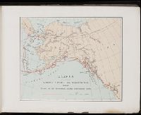
Creator:
Call Number:
ZZc86 899ha
Collection Title:
A souvenir of the Harriman Alaska Expedition : May-August, 1899 [graphic]
Image Count:
1
Resource Type:
Maps, Atlases & Globes
Abstract:
Edward Henry Harriman organized and funded a scientific expedition up the Alaska coast that included George Bird Grinnell, Grove Karl Gilbert, John Muir, Frederick Dellenbaugh, C. Hart Merriam, and other scientists, artists and writers, as well as his own
Subject (Geographic):
Alaska--Description and travel
Subject (Name):
Harriman Alaska Expedition (1899)--Pictorial works
Found in:
Beinecke Rare Book and Manuscript Library > Alaska with parts of Siberia Canada and Washington showing the route of the Harriman Alaska Expedition 1899
Call Number:
1977 +392
Collection Title:
A survey of the cities of London and Westminster : containing the original, antiquity, increase
Image Count:
1
Resource Type:
Maps, Atlases & Globes
Description:
Plate between p. 54-55.
Subject (Geographic):
London (England)--History
Collection Created:
London : Printed for A. Churchill, J. Knapton, R. Knaplock, J. Walthoe [and 6 others], 1720
Found in:
Beinecke Rare Book and Manuscript Library > Aldgate Ward with its division into parishes. Taken from the last survey, with corrections & additions
Creator:
Call Number:
C6 033c
Collection Title:
The natural and civil history of the French dominions in North and South America : with an
Image Count:
1
Resource Type:
Maps, Atlases & Globes
Description:
Plate between p. 68-9.
Subject (Geographic):
Atlantic Ocean--Charts, maps, etc., Atlantic Ocean--Maps--Early works to 1800, and Santo Domingo (Dominican Republic)
Collection Created:
London, Printed for T. Jeffreys, 1761
Found in:
Beinecke Rare Book and Manuscript Library > An authentic plan of the town and harbour of Cap Francois in the isle of St. Domingo. By Thomas Jefferys geographer to his Royal Highness the Prince of Wales
Call Number:
1973 Folio 114
Collection Title:
The English pilot: describing the West-India navigation, from Hudson's-Bay to the river Amazones
Image Count:
1
Resource Type:
Maps, Atlases & Globes
Subject (Geographic):
Atlantic Ocean --Maps --Early works to 1800, Central America --Maps --Early works to 1800, and Panama --Maps --Early works to 1800
Subject (Topic):
Navigation --Early works to 1800, Pilot guides --Atlantic Coast (U.S.) --Early works to 1800, and Pilot guides --Caribbean Area --Early works to 1800
Collection Created:
London : Printed for W. and J. Mount, T. Page and son, on Tower-Hill, MDCCLIX [1759]
Found in:
Beinecke Rare Book and Manuscript Library > An exact draught of the Gulf of Darien & the coast to Porto Bello with Panama in the South Sea & the Scotch settlement in Calledonia
Branch:v1.61.8 ,Deployed:2024-06-20T11:14:48-04:00