Skip to search
Skip to main content
Skip to first result
Search
You Searched For
Access
Public
Publication Place
London :
New Search
Search Results
Published / Created:
[1695]
Call Number:
2000 Folio 6 304
Image Count:
1
Alternative Title:
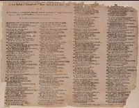
Robin Hood (Legend). English.
Description:
BEIN 2000 Folio 6 304: imperfect: mutilated at edges; part of imprint wanting. Mounted to 30 x 42 cm., Date from Wing., and Verse -- "Now Robin Hood, Will Scadlock, and little John,".
Publisher:
Printed for A. M[ilbourn] W. O[nley] and T. Thackeray ...,
Subject (Topic):
Ballads, English--England--Texts and Robin Hood (Legendary character)--Poetry--Early works to 1800
Found in:
Beinecke Rare Book and Manuscript Library > A new ballad of Robin Hood, William Scadlock, and Little John, or, Anarrative of their victory obtained against the Prince of Aragon and the two giants : and how William Scadlock married the Princess : to the tune of Robin Hood, or, Hey down, down a down.
Published / Created:
[ca. 1700]
Call Number:
2000 Folio 6 213
Image Count:
1
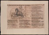
Alternative Title:
New ballad of Saint George and the dragon
Description:
BEIN 2000 Folio 6 213: Mounted to 30 x 42 cm., Date of publication from Wing., and Verse -- "Why would we boast of Arthur and his knights,".
Publisher:
Printed by and for W. O[nley] and sold by J. Blare on London-Bridge,
Subject (Name):
George,--Saint,--d. 303--Poetry
Subject (Topic):
Ballads, English--England--Texts
Found in:
Beinecke Rare Book and Manuscript Library > A new ballad of St. George and the dragon
Published / Created:
1802
Call Number:
907cea 1802
Container / Volume:
BRBL_00668
Image Count:
1
Resource Type:
Maps, Atlases & Globes
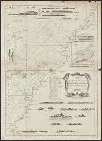
Description:
From Wittle, J. and Laurie, R.H., The West India Atlas, London, 1818. and Saililng chart showing anchorages, appearance of shore, ect., depths in fathoms, shoals rocks. "Norfork's Track 1801." Forts and settlement of Paramarabo, upstream. North at bottom.
Publisher:
Laurie & Wittle,
Subject (Geographic):
Guyana--Maps
Found in:
Beinecke Rare Book and Manuscript Library > A new chart of Surinam river (and the coast approaching it) to Paramarabo. Accompanied with sailing directions - views of the land, &c. - 1801.
Published / Created:
1827
Call Number:
85cea 1842
Container / Volume:
BRBL_00639
Image Count:
1
Resource Type:
Maps, Atlases & Globes
Description:
Eng. by J. Stephenson.
Publisher:
J.W. Norie & Co.,
Subject (Geographic):
West Indies--Maps
Found in:
Beinecke Rare Book and Manuscript Library > A new chart of the Caribbean Isles ... from Porto Rico to Trinidad ...
Published / Created:
[1760?]
Call Number:
3211cea 1760
Container / Volume:
BRBL_00055
Image Count:
1
Resource Type:
Maps, Atlases & Globes
Publisher:
Richard Mount and Thomas Page,
Subject (Geographic):
English Channel--Maps--Early works to 1800
Found in:
Beinecke Rare Book and Manuscript Library > A new chart of the Channell between England and France.
Published / Created:
1794
Call Number:
60cea 1794
Container / Volume:
BRBL_00329
Image Count:
1
Resource Type:
Maps, Atlases & Globes
Description:
Inset: Bay & Town of Mogadore. Ca. 1:20,000.
Publisher:
Laurie & Whittle,
Subject (Geographic):
Africa--Maps--Early works to 1800
Found in:
Beinecke Rare Book and Manuscript Library > A new chart of the Coast of Africa from the Straits of Gibralter to Cape Blanco with Madeira & the Canary Islands ...
Published / Created:
1790
Call Number:
556 1790
Container / Volume:
BRBL_00292
Image Count:
1
Resource Type:
Maps, Atlases & Globes
Publisher:
Robert Sayer,
Subject (Geographic):
Southeast Asia--Maps--Early works to 1800
Found in:
Beinecke Rare Book and Manuscript Library > A new chart of the Oriental Seas and Islands ... from the Isle of Ceylon to Amoye in China ... Mosr. Daprès de Mannevillette.
Published / Created:
[1760?]
Call Number:
3211cea 1760A
Container / Volume:
BRBL_00055
Image Count:
1
Resource Type:
Maps, Atlases & Globes
Description:
Inset: The Rivers Dee and Mersey ca. 1:400,000.
Publisher:
R. Mount and T. Page,
Subject (Geographic):
English Channel--Maps--Early works to 1800
Found in:
Beinecke Rare Book and Manuscript Library > A new chart of the Sea Coasts between England and Ireland.
Published / Created:
1710
Call Number:
Mhc8 1710 N42
Image Count:
30
Description:
In verse. and Title page mutilated.
Publisher:
Printed and sold by J. Baker,
Subject (Geographic):
Great Britain--History--Anne, 1702-1714--Pamphlets
Subject (Name):
Sacheverell, Henry,--1674?-1724
Subject (Topic):
Brit Tracts--1710 and Church and state--England--Poetry
Found in:
Beinecke Rare Book and Manuscript Library > A new extempore-prayer : fitted for the use of all conventicles, where rebellion has its rise, and loyalty its downfall
Creator:
Published / Created:
1772
Call Number:
Ea 770s
Image Count:
758
Resource Type:
Books, Journals & Pamphlets
Description:
Errata: 8 lines on p. xv., Imperfect: p. 17-18, 657-658, and all after p. 686 wanting. Date of publication and part of publisher's names torn from t.-p.; plate 3 mutilated., Includes index., and Page xv misnumbered vx.
Publisher:
Printed for C. Bathurst [etc.],
Subject (Name):
Robertson, William, 1721-1793
Subject (Topic):
Geography--Early works to 1800
Found in:
Beinecke Rare Book and Manuscript Library > A new geographical and historical grammar ... / by Mr. Salmon.
Branch:v1.61.8 ,Deployed:2024-06-20T11:14:46-04:00