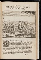
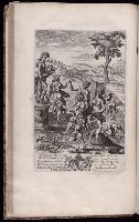
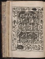
First ed., 2nd issue. Cf. Church., From t.p.: qua continentur I. Secunda pars nauigationum à Ioanne Hugone Lintschotano in Orientem susceptarum & maximè situs illarum regionum, & in his insularum, fluminum, riparum, portuum, &c. tum in transitu, tum ipsa India sitorum : vbi iuxta etiam vniuersa, quae autor illic, & postea in reditu versus Hollandiam vidit & notauit, diligenter designanter -- II. Nauigatio Hollandorum in insulas Orientales, Iauan & Sumatram, vbi pariter de moribus, vita, & religione incolarum quaedam haud iniucunda traduntur -- III. Tres nauigationes Hollandorum in modò dictum Indiam per Septentrionalem seu glacialem Oceanum, vbi mira quaedam & stupenda denarrantur., Imperfect: plate XXXII and 1 map wanting (Deliniatio cartae trium navigationum per Batavos ad Septentrionalem); q4 blank, wanting; wormed throughout, with loss of text. Some text redacted. The maps issued with this part, and a map and plate issued with part two, are bound before part 2 in the following order: [1] A cidade de Angra ... (40 x 55 cm. on sheet 41 x 57 cm, folded to 30 x 15); [2] Descriptio Hydrograhica accomodata ad Battavorum navagatione in Javam isulam Indiae Orientalis... (34 x 65 cm, on sheet 36 x 65 cm, folded to 29 x 18 cm); [3] Insula D. Helenae ... (22 x 28 cm, on sheet 30 x 31); [4] Munken so in den Orientalischen Indien ... (14 x 18 cm, on sheet 19 x 30 cm) bound with top of sheet at gutter; [5] Vera effigies et delineatio Insulae Ascenstio ... (15 x 22 cm, on sheet 19 x 30 cm) bound with top of sheet at gutter; [6] Insulae et arcis Mocambique ...(21 x 27 cm, on sheet 31 x 30 cm). No. 3 of 3 titles bound together., Leaf XXXII consists of 2 leaves ; five unnumbered maps are on [10] leaves; one unnumbered map is on [1] leaf., Maps: [1] Insula D. Helenae sacra ... [1601]. Scale not given. [2] Vera effigies et delineatio Insulae Ascenstio nuncupate ... [1601]. Scale not given. [3 (on two sheets)] Descriptio Hydrograhica accomodata ad Battavorum navagatione in Javam isulam Indiae Orientalis ... [1601]. Scale [ca. 1:25,000,000]. [4] A cidade de Angra ... [1601]. Scale not given. [5] Deliniatio cartae trium navigationum per Batavos ad Septentrionalem plaggem Norvegia, Moscovia et Novae Zembla ... autore Wilhelmo Bernardo ... [1601]. Scale [ca. 1:15,000,000]., Pt. I contains chapters 92-99 of Linschoten's Itinerario; pt. II is the 1st pt. of Willem Lodewijcksz' account of a voyage made to the East Indies in 1595-97., and Signatures: *⁴ A-X⁴ Y⁶ a-h⁴ i² k-q⁴ (*4,Y6, q4 blank).
Publisher:
Excudebat Matthaeus Beckerus,
Subject (Geographic):
East Indies--Description and travel--Early works to 1800. and East Indies--Discovery and exploration--Early works to 1800.
Subject (Name):
Becker, Matthias, fl. 1573-1606, publisher., Bry, Johann Israel de, -1611, printer., Bry, Johann Theodor de, 1561-1623?, printer., Linschoten, Jan Huygen van, 1563-1611. Secunda pars nauigationum., Lodewycksz, Willem, active 16th century. Navigatio Hollandorum in insulas Orientales., and Veer, Gerrit de. Tres navigationes Hollandorum.
A collection of works by various writers, compiled by Ashmole., Engraved ill. by Robert Vaughan are within borders decorated with birds, insects, small animals and flowers., No more published., and Wing (2nd ed., 1994) A3987
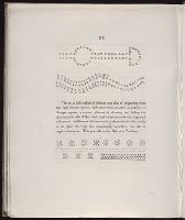
Between pp. 118-119: Folded plate (28 x 20 cm.) is engraved diagram with title: Here followeth the figure conteyning all the secrets of the treatise both great & small. It is signed in the plate: John Goddard sculpsit.
Description:
A collection of works by various writers, compiled by Ashmole., Bookplates and autograph: John William Kaye, 1835. Bookplate: Mary Mellon. Autograph: G. Furman, Brooklyn, L.I. Autographs & ms. notes: Chas. E. West., Engraved ill. by Robert Vaughan are within borders decorated with birds, insects, small animals and flowers., No more published., and Wing (2nd ed., 1994) A3987