Skip to search
Skip to main content
Skip to first result
Search
You Searched For
Resource Type
Maps, Atlases & Globes
Subject (Topic)
Railroads--Canada--Maps
New Search
Search Results
Creator:
Published / Created:
c1889.
Call Number:
75gme 1889
Container / Volume:
BRBL_00414
Image Count:
2
Resource Type:
Maps, Atlases & Globes
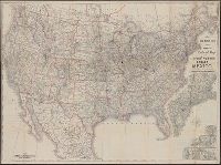
Alternative Title:
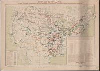
New official railroad map of the United States, Canada and Mexico.
Description:
Includes 9 insets., Insets: Atlantic Coast states, enlarged scale ; Important cities., Northern Canada and southern Mexico not shown., On verso: Publisher's advertisements., and Relief shown by hachures.
Publisher:
Rand McNally,
Subject (Topic):
Railroads--Canada--Maps, Railroads--Mexico, North--Maps, Railroads--North America--Maps, and Railroads--United States--Maps
Found in:
Beinecke Rare Book and Manuscript Library > Rand McNally & Co.'s new official railroad map of the United States, Canada, and Mexico.
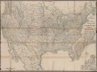
Creator:
Published / Created:
1891, c1889.
Call Number:
75gme 1891
Container / Volume:
BRBL_00414
Image Count:
2
Resource Type:
Maps, Atlases & Globes
Alternative Title:
New official railroad map of the United States, Canada and Mexico.
Description:
Includes 9 insets., Northern Canada and southern Mexico not shown., On verso: Indexes and publisher's advertisements., and Relief shown by hachures.
Publisher:
Rand McNally,
Subject (Topic):
Railroads--Canada--Maps, Railroads--Mexico, North--Maps, Railroads--North America--Maps, and Railroads--United States--Maps
Found in:
Beinecke Rare Book and Manuscript Library > Rand McNally & Co.'s new official railroad map of the United States, Canada, and Mexico.
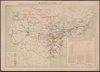
Creator:
Published / Created:
1943
Call Number:
71gm 1943
Container / Volume:
BRBL_00371
Image Count:
1
Resource Type:
Maps, Atlases & Globes
Description:
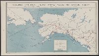
"26 March 1943.", "Map No.2014.", and Shows air routes, highways, projected highways, railroads, trails, and oil pipe lines under construction.
Publisher:
U.S. Office of Strategic Services,
Subject (Name):
United States. Board of Economic Warfare
Subject (Topic):
Railroads--Canada--Maps, Railroads--Northern Hemisphere--Maps, Transportation--Alaska--Maps, Transportation--Canada--Maps, and Transportation--Russia (Federation)--Siberia, Eastern--Maps
Found in:
Beinecke Rare Book and Manuscript Library > Transport facilities linking Canada, Alaska, and Eastern Siberia : Board of Economic Warfare, Project No.EP-17, O.E.W.A.
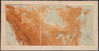
Creator:
Published / Created:
c1956.
Call Number:
753gme 1861
Container / Volume:
BRBL_00415
Image Count:
3
Resource Type:
Maps, Atlases & Globes
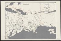
Description:
Depicts area from central Florida to Quebec and from Delaware to Iowa., Insets: Cal[ifornia] -- Texas., and Shows track gauge guages indicated by color.
Publisher:
George Rogers Taylor,
Subject (Name):
Williams, Robert L. (Robert Lee), 1917-
Subject (Topic):
Railroads--Canada--Maps and Railroads--United States--Maps
Found in:
Beinecke Rare Book and Manuscript Library > United States and Canadian railways, April 1, 1861 / compiled by George Rogers Taylor ; Robert L. Williams, map maker.
Branch:v1.64.3 ,Deployed:2024-09-25T10:53:04-04:00