United States. Adjutant-General's Office. Military Information Division
Published / Created:
[1898]
Call Number:
855hc 1898G
Container / Volume:
BRBL_00765
Image Count:
1
Resource Type:
Maps, Atlases & Globes
Abstract:
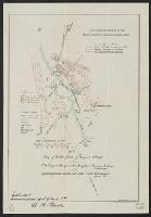
Shows troop positions in battle near Hormiguero and Mayaguez, Puerto Rico on Aug. 10, 1898.
Alternative Title:
Map of battlefield of August 10th 1898 between U.S. regular troops under Brig. Genl. Theodore Schwan, U.S. Volunteers and Spanish forces under Col. Julio Soto Villanueva, Alfonso XIII, Report of the Major General Commanding for 1898, and Report of the Major-Gen
Description:
"E.M. Eastwood, Del. Oct. 1898.", "Enclosure H to accompany report of Nov. 3, 1896 [sic], W.M. Black"--Bottom left., "To accompany the report of the Major General Commanding for 1898.", and Relief shown by form lines.
Publisher:
Norris Peters Co. Photo-litho,
Subject (Geographic):
Mayagüez Region (P.R.)--Maps
Subject (Name):
Eastwood, E. M and Norris Peters Co
Subject (Topic):
Spanish-American War, 1898--Campaigns--Puerto Rico--Maps
Also shows roads and tourist information., Covers the area southward from Mediterranean Sea to Lake Chad region and eastward from Algeria to Libya/Egypt border., and Maps on verso: Tunis -- Alger -- Tunisia Orient -- Tripoli [area] -- Tripoli -- Oran -- Africa, index map.
Publisher:
Corps of Engineers,
Subject (Geographic):
Africa, North--Maps, Tourist., Africa, North--Maps., Africa, North--Road maps., Chad, Lake, Region--Maps, Tourist., Chad, Lake, Region--Maps., and Chad, Lake, Region--Road maps.
"Compiled in April 1947 from AMS L-902 Japan City Plans, 1:12,500." and Text, indexes to military installations, dependent housing, visitor's aids, and ill. on verso.