Tabvla generalis Holsatiae complectens Holsatiae, Dithmarsiae, Stormariae, et Vagriae Dvcatvs
Description:
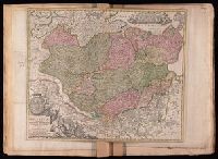
Bar scales given in "milliaria Germanica communia" and "milliaria Gallica sive horae itinerariae"., Includes coat-of-arms and ill., Prime meridian: Ferro., Relief shown pictorially., and Stamps on verso: 144 [crossed out]; 263. Title in ms. on verso. Backed with linen. Sheet measures 48.0 x 57.1 cm. No. 24 of 34 maps bound together.
Publisher:
[Johann Baptist Homann,
Subject (Geographic):
Schleswig-Holstein (Germany)--Maps--Early works to 1800