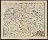
Accompanied by letter dated 10/9/1984 from the Algemeen Rijksarchief., Index giving names of 4 forts., Pictorial ills. of towns., and Upper right corner: 59.
Descriptio ac delineatio geographica detectionis freti, sive, transitus ad occasum supra terras
Image Count:
1
Abstract:
Map depicts the Coat of Arms of the United Kingdom (era of the Union of the Crowns), reigning between the years 1603-1707.
Alternative Title:
Tabula nautica, qua repraesentantur orae maritimae, meatus, ac freta, noviter a H. Hudsono Anglo ad Caurum supra Novam Franciam
Description:
Bound in after p. [2]., In pencil on recto: 170., Map cut and folded irregularly., Map has multiple small stains on both the recto and verso., and Scale [ca. 1:9,000,000].
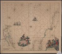
Terra Neuf, en de custen van Nieu Engeland, Nieu Nederland, Nieu Andalusia, Guiana en Venezuela
Description:
Covers the Atlantic Ocean west of the Azores and Cape Verde Islands, and the coasts of northeastern North America and northern South Amerca., Fr, In Latin and Dutch., Includes two decorative cartouches and ill., North oriented to left., and With "22" at top right.
Publisher:
Gedruckt by Fredrick de Wit in de Kalverstrae,
Subject (Geographic):
Atlantic Provinces--Maps--Early works to 1800 and North Atlantic Ocean--Maps--Early works to 1800
Subject (Name):
Wit, Frederik de. Orbis Maritimus ofte Zee Atlas
Subject (Topic):
Nautical charts--Atlantic Ocean--Early works to 1800
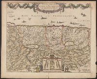
"20" in upper right corner., Along the top of the map is a garland supported by a cherubim; at bottom center, the encapment of the tribes flanked by Moses and Aaron is pictured., Appears in various editions of Wit's Atlas., Relief shown pictorially., and Sheet me
Publisher:
Gedruckt tot Amsterdam by Frederick de Wit in de Calverstraet by den Dam inde Witte Paskaert,
Subject (Geographic):
Palestine--History--To 70 A.D.--Maps and Palestine--Maps--Early works to 1800