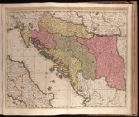
Backed with paper. Ms. no. "77" in upper right corner. Sheet measures 53.6 x 62.5 cm. No. 71 of 87 maps bound together., Bar scales given in "milliaria Hungarica" and "milliaria Germanica.", Covers Croatia, Bosnia and Hercegovina, Serbia, Montenegro and portions of Italy, Albania, Greece, Macedonia and Hungary., In Latin with place names in Italian., and Relief shown pictorially.
Bar scale given in "miglia sette.", Relief shown pictorially., and Sheet printed from cracked plate. Backed with paper. Ms. no. "72" in upper right corner. Sheet measures 53.7 x 62.6 cm. No. 67 of 87 maps bound together.
Publisher:
Joan Blaeu,
Subject (Geographic):
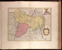
Parma (Italy : Province)--Maps--Early works to 1800. and Piacenza (Italy : Province)--Maps--Early works to 1800.
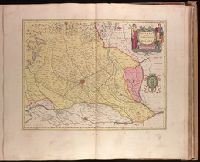
Backed with paper. Ms. no. "73" in upper right corner. Sheet measures 53.6 x 63.0 cm. No. 68 of 87 maps bound together., Bar scale given in "miglia sette d'Italia.", and Relief shown pictorially.
Publisher:
Joan Blaeu,
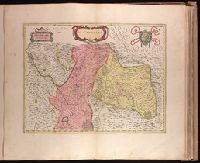
Subject (Geographic):
Milan (Italy : Province)--Maps--Early works to 1800.
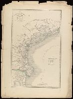
Appears in Giuseppe La Farina's history of Italy published 1851-1852 by Societa editrice italiana. and In lower left: La-Farina : Storia d'Italia dal 1815 al 1850.
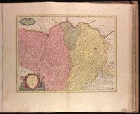
Backed with paper. Ms. no. "70" in upper right corner. Sheet measures 53.6 x 63.3 cm. No. 65 of 87 maps bound together., Bar scale given in "miglia cinque.", and Relief shown pictorially.
Publisher:
Joan Blaeu,
Subject (Geographic):
Belluno (Italy : Province)--Maps--Early works to 1800.
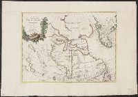
Backed with paper. Ms. no. "69" in upper right corner. Sheet measures 53.5 x 62.5 cm. No. 64 of 87 maps bound together., Bar scale given in "miglia cinque.", and Relief shown pictorially.
Publisher:
Joan Blaeu,
Subject (Geographic):
Italy, Northern--Maps--Early works to 1800. and Veneto (Italy)--Maps--Early works to 1800.
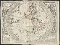
"Dedicato all illustrissimo, et eccellentissimo Signore Andrea Marcello, Senatore Amplissimo, e Fratello dell' Eccellentiss: Sigr. Federico, Procuratore di S. Marco"., From Coronelli's Atlante Veneto (1691)., Imperfect: mutilated. From the Karpinski-von Wieser Map Collection., Includes text and illustrations.Surrounding map border are "Tauola dell' Ombre Rette, e Meridiane..." and "Gradi di Latitudine, ridotti in Leghe di Germania, a 15 per Grado dell'Equatore" and "Gradi di Latitudine, ridotti in Migtia d'Italia, a 60 per Grado dell'Equatore", and signs of zodiac., Prime meridian: Ferro; coordinates converted by cataloger to express longitude based on Greenwich prime meridian., and Western hemisphere with California as an island on second Sanson model, with only C. Blanco named. Identifies "Terra di Iesso, Scoperta dagli Holland l'Anno 1643" to West, and mentions to North of California "In alcune Carte moderne uiene quiui situato lo Stretto d'Anian".
Publisher:
s.n.,
Subject (Geographic):
Western Hemisphere--Maps--Early works to 1800.
Subject (Name):
Coronelli, Vincenzo, 1650-1718. Atlante Veneto., Karpinski, Louis Charles,--1878-1956--Ownership., Karpinski-von Wieser Map Collection., Sacro Bosco, Joannes de, active 1230., and Wieser, Franz,--Ritter von,--1848-1923--Ownership.