Skip to search
Skip to main content
Skip to first result
Search
You Searched For
Extent of Digitization
Partially digitized
Genre
Engravings
New Search
Search Results
Call Number:
1976 Folio 94
Collection Title:
A new universal atlas containing maps of the various empires, kingdoms, states and republics of the
Image Count:
1
Resource Type:
Maps, Atlases & Globes
Subject (Geographic):
Maine
Collection Created:
Philadelphia, S.A. Mitchell, 1849
Found in:
Beinecke Rare Book and Manuscript Library > A new map of Maine
Creator:
Published / Created:
1775 September
Call Number:
A89 P384
Collection Title:
The Pennsylvania magazine: or, American monthly museum
Image Count:
1
Resource Type:
Books, Journals & Pamphlets
Description:
Verso blank.
Subject (Name):
Paine, Thomas, 1737-1809
Collection Created:
Philadelphia, Printed and sold by R. Aitken [1775-1776]
Found in:
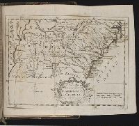
Beinecke Rare Book and Manuscript Library > A new map of North & South Carolina, & Georgia
Call Number:
1977 +379
Collection Title:
Geografia; cioe, Descrittione vniversale della terra. Partita in due volumi, nel primo de' quali si
Image Count:
1
Alternative Title:
[Geographia. Italian]
Subject (Geographic):
Africa. and Guinea
Subject (Topic):
Geography
Collection Created:
In Padova, Appresso Paolo, & Francesco Galignani, fratelli, 1620-21 [v.1, 1621]
Found in:
Beinecke Rare Book and Manuscript Library > A new map of that part of Africacalled the coast of Guinea ...
Creator:
Published / Created:
[1732]
Call Number:
E1015 M66 1732
Collection Title:
Atlas minor: or a set of sixty-two new and correct maps, of all parts of the world. All composed
Image Count:
1
Description:
Autograph of Gravely. Autograph of Baldock. Autograph of Aston. Autograph of W. Alington.
Subject (Geographic):
America--Maps--Early works to 1800
Subject (Topic):
Atlases--Early works to 1800
Collection Created:
London :
Found in:
Beinecke Rare Book and Manuscript Library > A new map of the whole world with the trade winds according to ye latest and most exact observations by H. Moll geographer.
Creator:
Published / Created:
[1732]
Call Number:
E1015 M66 1732
Collection Title:
Atlas minor: or a set of sixty-two new and correct maps, of all parts of the world. All composed
Image Count:
1
Description:
Autograph of Gravely. Autograph of Baldock. Autograph of Aston. Autograph of W. Alington.
Subject (Geographic):
America--Maps--Early works to 1800
Subject (Topic):
Atlases--Early works to 1800
Collection Created:
London :
Found in:
Beinecke Rare Book and Manuscript Library > A new map of ye north parts of America claimed by France under ye names of Louisiana. Mississipi, Canada & New France, with the adjoyning territories of England & Spain. By H. Moll geographer.
Creator:
Published / Created:
Undated
Call Number:
1973 Folio 71
Collection Title:
[Atlas nouveau contenant toutes les parties du monde ou sont exactement marques les empires
Image Count:
1
Resource Type:
Maps, Atlases & Globes
Abstract:
Factitious collection of about 549 maps taken from the atlases of the 17th and the beginning of the 18th century, put together with the title "Atlas" and bound in 6 volumes. These volumes originally bore the imprint: Amstelaedamii apvd Reiniervm & Josvam Ottens. Over these words on the title pages of volumes 1-2 and 4-6 is the name of Henrik de Leth who painted them.
Description:
Verso blank.
Subject (Geographic):
British Isles --Maps --Early works to 1800
Subject (Name):
Leth, Hendrik de, 1703-1766, Reiner et Josua Ottens (Firm), Schenck, Peter, 1661-1715, Schenck, Peter, ca. 1698-1752, Valck, G. (Gerard), 1651 or 2-1726, and Wit, Frederik de
Subject (Topic):
Atlases --Early works to 1800
Collection Created:
[A Amsterdam, chez J. Covens & C. Mortier, ca. 1730-ca. 1800]
Found in:
Beinecke Rare Book and Manuscript Library > A new mapp of the kingdome of England, representing the princedome of Wales, and other provinces, cities, market towns, with the roads from town to town and the number of reputed miles between them, are given by inspection without scale or compass
Creator:
Published / Created:
1836
Call Number:
1976 Folio 98
Collection Title:
A new universal atlas, containing maps of the various empires, kingdoms, states and republics of
Image Count:
1
Resource Type:
Maps, Atlases & Globes
Description:
Illustrated vignette depicting the first landing of Columbus in the new world.
Collection Created:
Philadelphia, Published by the author, 1836
Found in:
Beinecke Rare Book and Manuscript Library > A new universal atlas, containing maps of the various empires, kingdoms, states and republics of the world ...
Published / Created:
1724 June 6
Call Number:
Osborn fc166
Collection Title:
Prints by William Stukeley 1750
Image Count:
1
Abstract:
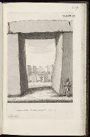
Album containing 122 engravings by Stukeley, many in proof, assembled by the artist himself. Contents include 85 engravings from Itinerarium Curiosum and 23 from Stonehenge, a Temple Restor’d to the British Druids.
Description:
Plate numbered 104.
Subject (Geographic):
Great Britain --Antiquities --Early works to 1800 and Wiltshire (England) --Antiquities
Subject (Topic):
Megalithic monuments --England --Wiltshire and Stonehenge (England)--Early works to 1800
Found in:
Beinecke Rare Book and Manuscript Library > A peep into the sanctum sanctorum
Creator:
Published / Created:
Undated
Call Number:
JJr25 32g
Collection Title:
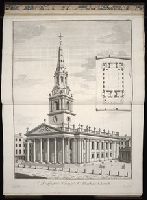
A book of architecture, containing designs of buildings and ornaments. By James Gibbs
Image Count:
1
Resource Type:
Books, Journals & Pamphlets
Subject (Topic):
Architecture --Designs and plans
Collection Created:
London, 1728
Found in:
Beinecke Rare Book and Manuscript Library > A perspective view of St. Martins church
Call Number:
1977 Folio 78
Collection Title:
A New and accurate chart of the West-India Islands and coast, with the gulf passage through the New
Image Count:
1
Resource Type:
Maps, Atlases & Globes
Alternative Title:
Petit Guave in the island of Hispaniola, pl. 32
Subject (Geographic):
Hispaniola
Subject (Topic):
Nautical charts
Collection Created:
London, Printed for Robert Sayer and John Bennett, Fleet-Street, 1779
Found in:
Beinecke Rare Book and Manuscript Library > A plan of Fort St. Louis harbour on the south side of Hispaniola, pl. 31.
Branch:v1.61.8 ,Deployed:2024-06-20T11:14:46-04:00