"Amstelodami cum privilegio D.D. ordin. Hollandiae Westfrisiaeq[ue].", Backed with paper., Illustrated hand colored title cartouche; sea decorated with ships., Prime meridian: Ferro., and Relief shown pictorially.
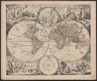
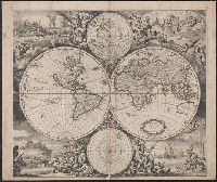
Allegorical vignettes of the four seasons., Cf. Shirley, R. Mapping of the world, no. 545., Cross Collection no. 25., and Double hemisphere, with smaller polar insets.
Imperfect: mutilated along folds, with some loss of text. Cross collection no. 24., Includes ill. and ancillary maps of north and south polar regions., and Relief shown pictorially.
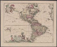
"Cum Privilegio D.D. Ordinum Holl. Westfriliegs.", Appears in various editions of Wit's Atlas., Includes note, "America" in ornamental cartouche., Mounted on linen. Sheet measures 50 x 60.5 cm. Cross Collection no. 135., Prime meridian: Ferro., Relief shown pictorially., Shows the Western Hemisphere with national boundaries, cities and rivers; shows California as an island., Text in Latin., and Title from ornamental cartouche.
Publisher:
Ex officina I. Covens et C. Mortier,
Subject (Geographic):
America--Maps--Early works to 1800 and Western Hemisphere--Maps--Early works to 1800
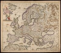
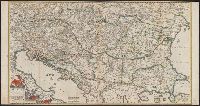
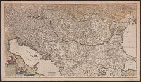
Hungariae et regionum, quae ei quondam fuêre unitae
Description:
Covers Balkan Peninsula south of lat. 50⁰N., Includes col. ill. in title cartouche., and Relief shown pictorially.
Publisher:
Frederici de Wit,
Subject (Geographic):
Balkan Peninsula--Administrative and political divisions--Maps--Early works to 1800, Balkan Peninsula--Maps--Early works to 1800, and Hungary--Maps--Early works to 1800
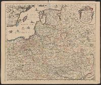
Regni Poloniae et Ducatus Lithvaniae Voliniae, Podoliae Vcraniae Prvssiae, Livoniae et Cvrlandiae descriptio
Description:
303 1660: Imperfect: lower left corner chipped, with no loss of text. Sheet measures 53.0 x 62.5 cm., Appears in various editions of Wit's Atlas., Bar scale given in "Duytsche Mylen.", Prime meridian: Ferro., Relief shown pictorially., and Variant giving westernmo
Publisher:
[Frederik de Wit,
Subject (Geographic):
Baltic States--Maps--Early works to 1800, Belarus--Maps--Early works to 1800, and Poland--Maps--Early works to 1800
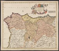
Regni Poloniae et Ducatus Lithvaniae Voliniae, Podoliae Vcraniae Prvssiae, Livoniae et Cvrlandiae descriptio
Description:
Appears in various editio, Bar scale given in "Duytsche Mylen.", Prime meridian: Ferro., Relief shown pictorially., Sheet measures 52.2 x 61.6 cm., Variant giving westernmost longitude at 35 degrees and easternmost longitude at 63 degrees., and Watermark.
Publisher:
[Frederik de Wit,
Subject (Geographic):
Baltic States--Maps--Early works to 1800, Belarus--Maps--Early works to 1800, and Poland--Maps--Early works to 1800