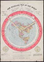
Map of the globe stretched and flattened into a circular plane (azimuthal projection), with two movable arms to calculate time in places around the world
Alternative Title:
New standard map of the world
Description:
Map of the globe stretched and flattened into a circular plane., Includes longitude and time calculator and diagrams showing June and December solstices., Border shows "sun-time in minutes.", and Text on verso.
Bankoku ichiranzu, Bankoku ichiran zusetsu, and (Explanation of the visualized map of all the countries)
Description:
BEIN 2018 +512: Manuscript annotations in English on margins of map., Cover attached; cover and map title the same., Accompanied by: BANKOKU ICHIRAN ZUSETSU : (Explanation of the visualized map of all the countries) / Koyano Yoshiharu. -- Bunka 7 : (1810). -- 2 v., ill. ; 25.2 x 18 cm., Kôzanrō is a private school of Koyano Yoshiharu., and California shown as an island.
Publisher:
Kôzanrô, (June, 1809)
Subject (Geographic):
Japan and Japan.
Subject (Topic):
World maps, Geography, Study and teaching, and Prints, Japanese