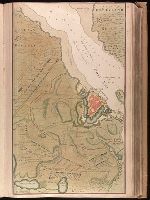
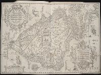
Backed with paper. Ms. no. "13" in upper right-hand corner. Sheet measures 53.6 x 35.5 cm. No. 13 of 87 maps bound together., Bar scale given in "Duytsche Mylen"., Relief shown pictorially; depths shown by soundings., Shows troop positions during siege of Stralsund during the Northern War, ca. 1715., and Title derived from place locations on map.
Publisher:
By Gerard van Keulen ...,
Subject (Geographic):
Rügen Island (Germany)--Maps--Early works to 1800. and Stralsund (Germany)--Maps--Early works to 1800.
Subject (Name):
Anse, Luggert van, fl. 1690-1716, engraver.
Subject (Topic):
Nautical charts--Baltic Sea--Early works to 1800. and Northern War, 1700-1721--Maps.
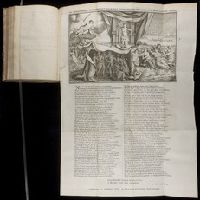
From Augustin Calmet's Byvoegzel tot het algemeen groot historisch, oordeelkundig, chronologisch, geografisch, en letterlyk naam- en woord-boek (1731). and Watermark.
Publisher:
[Samuel Luchtmans],
Subject (Geographic):
Antioch (Turkey)--Pictorial works--Early works to 1800.
Subject (Name):
Calmet, Augustin, 1672-1757. Byvoegzel tot het algemeen groot historisch, oordeelkundig, chronologisch, geografisch, en letterlyk naam- en woord-boek. and Luchtmans, Samuel, 1685-1757
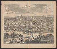
Bird's-eye view., Dutch and English., From Ogilby's Africa, being an accurate description of the regions of Egypt, Barbary, Lybia and Billedulgerid. 1670., Has watermarks., Includes ill. and indexes of points of interest., and Relief shown pictorially.
Publisher:
Printed by T. Johnson for the author,
Subject (Geographic):
Loango (Congo)--Aerial views--Early works to 1800
Subject (Name):
Ogilby, John, 1600-1676. Africa, being an accurate description of the regions of Egypt, Barbary, Lybia and Billedulgerid
Tafelronde, Tafelronde (Antwerp, Belgium), and Tafelronde/Impuls
Description:
Began with Eerste jaargang, nummer 1 (januari 1953); ceased with vierentwintigste jaargang, nummer 2/3 (december 1981)., Frequency varies., Imprint varies., and Subtitle varies.
Publisher:
Astra,
Subject (Topic):
Avant-garde (Aesthetics)--Belgium--Periodicals, Concrete poetry--Periodicals, Literature, Experimental--Periodicals, and Sound poetry--Periodicals
Navigatio ac itinerarivm Iohannis Hvgonis Linscotani in Orientalem sive Lvsitanorvm Indiam
Image Count:
1
Description:
[Scale ca. 1:19,000,000]., Bound in following page 36., and Map has significant tears at bottom right and left, as well as a tear along the bottom center fold.
Subject (Geographic):
Brazil --Maps --Early works to 1800, Chile --Maps --Early works to 1800, Peru --Maps, and South America --Maps --Early works to 1800
Subject (Name):
Claesz, Cornelis, ca. 1546-1609, Elzevier, Gillis, bookseller, and Hendricksz, Aelbrecht, fl. 1573-1605, printer
Subject (Topic):
Voyages and travels --Early works to 1800
Collection Created:
Hagae-Comitis : Ex officina Alberti Henrici, impensis authoris & Cornelii Nicolai, prostantque apud Aegidium Elseuirum, anno 1599