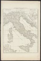
Anville, Jean Baptiste Bourguignon d', 1697-1782, cartographer
Call Number:
400 1764
Container / Volume:
BRBL_00233
Image Count:
1
Resource Type:
Maps, Atlases & Globes
Description:
Appeared in Anville's Atlas général., Hand colored in outline., Includes 2 insets of Rome city region and "Urbs septicollis.", Includes four bar scales., Relief shown pictorially., and Watermark.
Subject (Geographic):
Italy--Historical geography--Maps--Early works to 1800 and Rome--Maps
Subject (Name):
Anville, Jean Baptiste Bourguignon d', 1697-1782. Atlas général
Appears in N. Vischer's Atlas minor sive geographia compendiosa, 1684., In lower right margin: Gedruckt t'Amsterdam by Frederick de Wit voor inde Calverstraet by den dam inde witte Pascaart., Map of Russian Far East, China and, and Sheet measures 45.5 x 56.5 cm.
Subject (Geographic):
China--Maps--Early works to 1800, Japan--Maps--Early works to 1800, and Russia (Federation)--Maps--Early works to 1800
Subject (Name):
L'Huilier, Joannes, engraver and Visscher, Nicolaes, 1649-1702. Atlas minor
Mounted on linen., Relief shown pictorially., and Variant without inset of "Fort Frederick oder Crown Point"; see B.B. McCorkle, Early printed maps of New England 1513-1800, 755.34.